Oakridge, Westfir evacuated due to Cedar Creek Fire, Conflagration Act declared, Hwy. 58 closed; more new fires
(Update: Oakridge, Westfir evacuated, Hwy. 58 closure extended)
OAKRIDGE, Ore. (KTVZ) – The Oakridge and Westfir areas were evacuated Friday evening and a Highway 58 closure was lengthened 65 miles in the face of the Cedar Creek Fire as predicted windy conditions also sparked other wildfires around the Northwest that forced people to also flee their homes.
“Do NOT take time to gather things. GO NOW!” the Lane County Sheriff’s Office said in its 7:15 p.m. update on Facebook, having warned area residents hours earlier in a Level 2 “Get Set” alert that the danger was rising.
ODOT widened its closure of Highway 58 from milepost 5, a mile east of Pleasant Hill on the west to milepost 70 at Crescent Lake on the east. Evacuees were advised to travel west on Highway 58 to the temporary evacuation point at Lane Community College, Building 16, and travelers were urged to avoid the area and take alternate routes.
Another fire had some residents of South Salem evacuating Friday evening, KPTV reported, and there also were Level 3 “Go!” evacuation orders for the Kalama Fire in Cowlitz County, Washington, after Gifford Pinchot National Forest officials said a fire had grown from four acres to 80 acres overnight.
In Washington County west of Portland, two fires broke out near Hagg Lake and were brought under control, but sheriff's deputies said the high winds mean a Level 2 evacuation notice remains in place on SW Stepien Road, with residents asked to leave if possible.
The Oregon Department of Forestry said a statewide task force created earlier this week is working with several structure-protection strike teams focused on protecting Oakridge and other nearby private lands.
"The task force is currently scouting access points and planning their attack in the event the east winds drive the fire off federal and onto private lands," a Friday night news release said.
Elsewhere, the Oregon Department of State Lands closed Elliott State Forest and South Slough National Esturaine Research Reserve to the public due to extreme fire danger.
The latest Cedar Creek Fire updates can be found at the Cedar Creek Fire Facebook page. Get traffic updates at our TripCheck page.
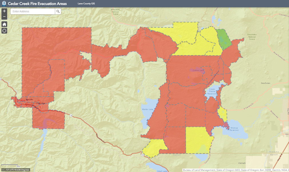
The evacuation map is at: https://lcgisorg.maps.arcgis.com/apps/webappviewer/index.html?id=fffd5cd4131d40bc885331fe3c905283
Governor Kate Brown Invokes the Emergency Conflagration Act in Response to the Cedar Creek Fire
Cedar Creek Fire is burning 33,100 acres in Lane and Deschutes Counties
(Portland, OR) — Governor Kate Brown invoked the Emergency Conflagration Act this afternoon as a preemptive measure in response to the Cedar Creek Fire burning in the National Forest east of the community of Oakridge in Lane County. This declaration allows the Office of State Fire Marshal (OSFM) to mobilize resources to support local fire service agencies in Lane County to carry out their plan to protect lives, homes, and critical infrastructure. Fire activity significantly increased because of weather and the fire was estimated at 33,100 acres as of Friday morning. Lane County Sheriff's Office has issued evacuation orders for areas near the fire.
"The Cedar Creek Fire grew rapidly towards Oregon communities this morning, and the fire's growth potential in the coming days is troubling, requiring additional resources to battle the fire and support the state's response," said Governor Brown. "This is a good reminder that conditions can change quickly, and that fire knows no bounds. With forecasted weather conditions this week and numerous fires in the wilderness areas near communities, it is important for all Oregonians to be prepared. Follow all evacuation orders and continue to follow local and statewide fire prevention regulations to keep our communities safe and our natural resources protected."
In accordance with ORS 476.510-476.610, Governor Brown determined that a threat to life, safety, and property exists due to the fire, and the threat exceeds the firefighting capabilities of local firefighting personnel and equipment. The Governor's declaration cleared the way for the State Fire Marshal to mobilize firefighters and equipment to assist local resources battling the fire and further support a coordinated response.
The Cedar Creek Fire has been burning in the wilderness for a month. Local fire service agencies increased staffing and plan to protect life and structures in the surrounding communities. The Oregon State Fire Marshal has been engaged with the fire defense board chief to determine fire response needs. This declaration clears the way for additional resources to respond to support the local fire service agencies. The OSFM will continuously assess response needs with the forecasted weather and fire conditions and bring in additional task forces through the Oregon Fire Mutual Aid System (OFMAS).
Additional updates for the incident may be accessed at:
- Oregon State Fire Marshal Facebook page
- OSFM Incident Information Blog OSFMInfo.org
- Cedar Creek Fire Facebook page
- For Evacuations in Lane County: Lane County Sheriff’s Office
Information on wildfire prevention and preparedness may be accessed at:
Earlier Friday, the Deschutes National Forest expanded the temporary emergency closure area implemented as a result of the increased fire activity on the Cedar Creek Fire, which has now topped 33,000 acres.
The Cedar Creek Fire is currently burning about 20 miles west of La Pine. For the safety of the public and firefighters, the Bend-Fort Rock and Crescent Ranger Districts on the Deschutes National Forest will temporarily close all Forest Service-managed roads, trailheads and trails within the temporary Cedar Creek Fire Closure (#06-01-22-03) area (See attached map). This closure will remain in place until rescinded.
The following are closed under the temporary Cedar Creek Fire Closure Order (Closure #06-01-22-03) –
Trailheads –
• Blue Lagoon Trailhead
• Charlton Lake Trailhead
• Corral Swamp Trailhead
• Deer Lake Trailhead
• Elk Lake Trailhead
• Irish & Taylor Trailhead
• Lemish Lake Trailhead
• Lucky Lake Trailhead
• Many Lakes Trailhead
• Moore Creek Trailhead
• Sisters-Mirror Lake Trailhead
• Six Lakes Trailhead
• Winopee Lake Trailhead
Campground & Recreation Sites --
• Big Cove Boat-In Campground
• Browns Crossing Wildlife Viewing
• Browns Mountain Boating
• Cow Meadow Campground
• Crane Prairie Campground & Day Use Area
• Cultus Corral Horse Camp
• Cultus Lake Campground & Day Use Area
• Cultus Lake Picnic Area
• Deschutes Bridge
• Lava Lake Campground & Day Use Area
• Little Cove Boat-In Campground
• Little Cultus Campground & Boat Ramp
• Little Lava Lake Campground & Day Use Area
• Mile Camp Day Use
• North Davis Creek Campground & Boat Ramp
• Osprey Point Interpretive Trail
• Quinn River Campground & Day Use
• Rock Creek Campground & Day Use
• West Cultus Boat-In Campground
This closure also specifically closes the Pacific Crest Trail (PCT) from Highway 58 north to the intersection with the Wickiup Plains Trail #12.2. Long distance hikers can rejoin the PCT at the Devils Lake/Wickiup Plains Trailhead. Visit the pcta.org for current information about closures.
The Cedar Creek Fire was caused by a lightning strike reported on August 1 and is burning on the Willamette and Deschutes National Forests. The fire is now 33,099 acres and is 12% contained. The fire is currently being managed by Northwest Incident Management Team 6 on the west side and Alaska Interagency Incident Management Team 1 on the east side. For information on the Cedar Creek Fire, please visit https://inciweb.nwcg.gov/incident/8307/.
Cedar Creek Fire update - August 9, 2022
Size: 33,099 acres
Contained: 12%
Start Date: August 1, 2022
Location: 15 miles E of Oakridge, OR
Cause: Lightning
Total personnel: 862
Resources: 27 engines
15 crews
31 heavy equipment
7 helicopters
2 scoopers
Lane Electric Cooperative will implement a public power safety shutoff starting at 5 p.m. on Friday, September 9 through the evening of Sunday, September 11. This outage will impact nearly all members, with the city centers of Oakridge, Lowell, and Veneta remaining powered to provide key services. Call or visit 541-484-1151 Lane Electric for updates or changes.
Current Situation: East winds, low humidities, and high temperatures will cause the fire to be active today. The highest activity will occur where lichen is present in trees and there is a high concentration of down wood. Where winds align with slopes, tree canopy fire and fire spotting are anticipated. Last night scouting occurred at high points to assess fire growth but smoke limited visibility. The fire spotted over the Winchester Trail to the north. Alaska Team 1 has joined Northwest Team 6 to manage the eastern side of the fire. This has brought key middle management personnel to the fire and allows firefighters to have shorter driving times to the east side of the fire.
Today’s Activities: With critical fire weather expected today, operations leaders will be continuously assessing fire growth and focusing on strategic placement of firefighters in anticipation of changing conditions throughout the day. Firefighters are working on fireline from north Waldo Lake to Charlton Lake connecting to Forest Service Road 4290 to hold the fire from continuing to move south. On Forest Service Road 2421 firefighters will be watching for any spot fires and holding the fire at the road. Crews will be engaging the spot fires north of the Winchester Trail trying to extinguish them if safe to do so. Firefighters are also coordinating with the Middle Fork Ranger District and Lane County Oregon State Fire Marshal representative in order to provide initial attack support to any new fire starts that could occur.
Weather: A RED FLAG Warning is in effect today through at least Saturday due to hot, dry, and windy conditions. East Winds speeds are expected to be 15-25 with gusts of up to 50 mph on ridges. Toward the afternoon the valley will become windy. Poor humidity levels overnight will allow for an extended burn window.