Growing Cedar Creek Fire triggers upgraded, wider Level 3 evacuations, including Cultus Lake

'Very tense,' cabin evacuee says
BEND, Ore. (KTVZ) –The growing Cedar Creek Fire that sent smoke pouring into the skies over Central Oregon Tuesday evening also prompted evacuation of Cultus and Little Cultus lakes, among other areas threatened by the blaze, authorities said.
Tom Payfer told NewsChannel 21 that Cultus Lake cabin renters were evacuated around 7:45 p.m., as officials said the fire had moved to about a mile away.
Payfer also said services were turned off to the cabin, so “renters were scrambling to gather up their belongings into dark vehicles, then escaping the camp being closed. Very tense.”
Here’s the Lane County Sheriff’s Office announcement as posted on the Cedar Creek Fire Facebook page:
CEDAR CREEK FIRE EVACUATION LEVEL INCREASES
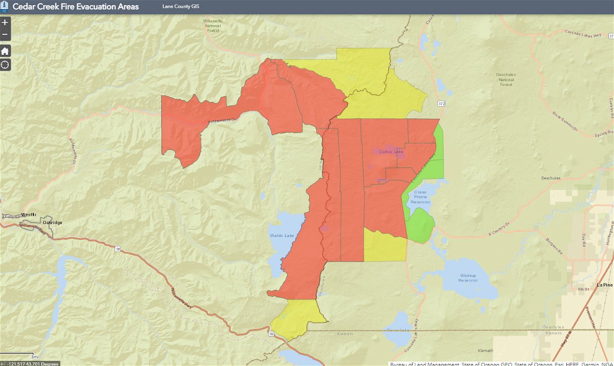
Link to evacuation level map https://lcgisorg.maps.arcgis.com/apps/webappviewer/index.html?id=fffd5cd4131d40bc885331fe3c905283
Increased fire activity has prompted an increase in evacuation levels for areas around the Cedar Creek Fire. In addition to all previously issued evacuation notices remaining in effect, the Lane County Sheriff’s Office has issued the following evacuation level increases:
LEVEL 3 (GO NOW) EVACUATION NOTICES HAVE BEEN ISSUED FOR THE FOLLOWING AREAS
• McFarland lakes & Elk Creek Trail areas
Level 3 means leave immediately! Do NOT take time to gather things. GO NOW! There is immediate and imminent danger and you should evacuate immediately.
LEVEL 2 (BE SET) EVACUATION NOTICES HAVE BEEN ISSUED FOR THE FOLLOWING AREAS:
• Mink Lake Basin
Level 2 means: You must prepare to leave at a moment’s notice, and this may be the only notice that you receive.
The Deschutes County Sheriff’s Office has announced the following evacuation levels and corresponding areas:
LEVEL 3 (GO NOW) EVACUATION NOTICES HAVE BEEN ISSUED FOR THE FOLLOWING AREAS
Previous Level 2 evacuation areas including Johnny Lake, Clover Meadow, Lemish Lake, Many Lakes area, north to the line between Township 19 and 20 (approximately milepost 40.5 on Cascade Lakes Hwy). All areas west of the Cascade Lakes Hwy north of FS 4290 (Charlton Lake Road) north to Deschutes Bridge Area. This includes Cultus Lake, Little Cultus Lake, Corral Swamp, and the areas around Lemish and Ketchketch Buttes.
LEVEL 2 (BE SET) EVACUATION NOTICES HAVE BEEN ISSUED FOR THE FOLLOWING AREAS:
Areas west of Cascade Lakes Hwy and south of FS 4290 (Charlton Lake Road) south to the line between Township 21 and 22 (approximately milepost 54 on Cascade Lakes Hwy). Areas between the Metolius – Windigo Trail / Six Lakes Trail and the County Line including Winopee Lake, Snowshoe Lakes and Leech lake.
LEVEL 1 (READY) EVACUATION NOTICES HAVE BEEN ISSUED FOR THE FOLLOWING AREAS:
Areas around the west side of Crane Prairie from Deschutes Bridge south to FS 42 (South Century Drive including Browns Mountain, Cow Meadow, Quinn Meadow, and Rock Creek Campgrounds.
Public safety personnel cannot guarantee they will be able to notify you if conditions rapidly deteriorate. Continue to closely monitor your phone, local media and www.LaneCountyOR.gov/CedarCreek for information.