Little Lava Fire jumps to 10,000 acres before rain, cooldown; evacuation zones hold, but flames’ advance stopped
(Update: Adding video, comments from NW Management Team 3, Three Rivers residents)
BEND, Ore. (KTVZ) – After five days of the Little Lava Fire racing across 10,000 acres and advancing miles a day toward populated areas, evacuation zones are being held steady for now, but a favorable change in the weather has helped firefighters stop its forward progress, and that's boosting hopes people won't have to leave.
"It's hard to pick what you're going to save. You know, I got tools, I got skis, got a lot of hunting gear," said Tom Bourett, a resident of Three Rivers, south of Sunriver. "You don't know. This is our first time."
Lloyd Clark said, "We took our cars and a motor home into town and stayed in town overnight. Not sure what was going to happen, so we were prepared. We have dogs. We took them with us. But, you know, we were just being proactive."
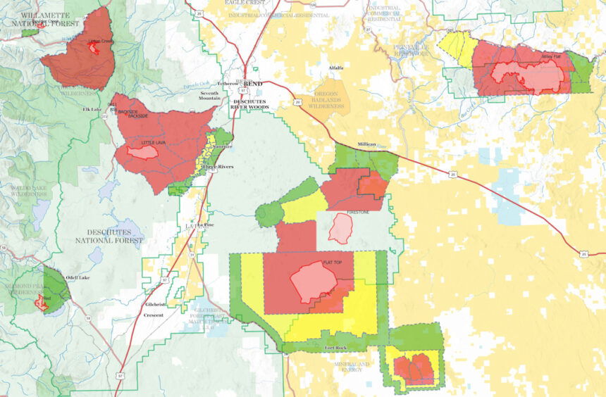
The Bachelor Complex is made up of 30 lightning-sparked fires. that broke out last weekend. The Little Lava Lake Fire has burned over 9,500 acres, by far the largest of the group. It's about five to seven miles west of Sunriver and the Three Rivers community.
Brett Thomas, the Northwest Team 3 operations director, said "The next several shifts, we just will have extremely favorable conditions for us to engage directly with the fire's edge and be actively mopping up, dealing with hazard trees and putting in direct containment line both on on this portion of the fire."
Despite much of the populated area being in a Level 2 "BE SET" zone, fire officials are optimistic those evacuation levels will not increase further, to Level 3 - "GO NOW."
Bourett said, "I've got a whole bunch of trees around our house to make a more defensible space, and I've helped people evacuate, but I've never had to evacuate myself. So it's kind of a weird feeling, you know - kind of like in limbo."
Clark said, "I've been here almost six years and we haven't been that close to a fire in that time. I know folks in La Pine have had this issue several times, and we know people there have had to evacuate. So this was for me the first time."
Changes in weather patterns have helped fire fighters get a better grip on the fire.
Thomas said, "it's certainly -it's been a tremendous help. We were in a bit of a defensive mode yesterday (Tuesday), of course. And with the higher relative humidity and the added moisture, we've actually been able to get right on the fire's edge, starting last night."
Several folks NewsChannel 21 spoke to in the Three Rivers area have expressed frustration regarding fire updates, saying many didn't have anywhere to go when Level 2 evacuation orders came.
Clark said, "It feels like a lot of times that Three Rivers is a forgotten community, because there's been so little communication. For example, yesterday was a Level 2. So you get ready to go, people move their trailers. Where do we go? Nobody gave us a location that we should, - you know, we stayed with friends. Not everybody has friends."
Firefighters are actively working on containment on the eastern side of the fire to protect the Sunriver and Three Rivers community. Forward progress of the fire toward Sunriver has stopped, according to Thomas.
Here's the Wednesday afternoon update from the team overseeing the Bachelor Complex and two other large fires to the east that are likely to merge:
Pacific Northwest Complex Incident Management Team 3
Lonnie Click ~ Incident Commander
September 11, 2024
Bachelor Complex and Flat Top and Firestone Fires Update
Firefighters continued to work on suppressing the Bachelor Complex, Flat Top and Firestone Fires which actively burned on Tuesday. The Deschutes County Sheriff’s Office expanded the areas in Evacuation Levels for public safety and adjusted the interactive map on their website to reflect the changes. (Link below). A public meeting will be held at the Three Rivers Elementary School cafeteria in Sunriver at 6:00 p.m. today. Firefighting resources continued to arrive, and engage, and aircraft continued to drop water and fire retardant on fire areas. Additional air resources are also incoming with a helibase to be established at Sunriver Airport on Wednesday. Smoky skies are expected to improve by evening.
Bachelor Complex: The Bachelor Complex is a group of about 30 fires that range from one tenth of an acre to over 9,500 acres, for a total of 10,330 acres. The Little Lava Fire, about two miles southeast of Little Lava Lake, was very active again on Tuesday, pushed by wind moving across Forest Service Road 45 nearly three miles to the east with a total fire size of approximately 9,848 acres by day’s end. Firefighters constructed dozer line to slow fire spread. Firefighters worked both a swing shift and a night shift last night and made great progress constructing line around the fire that crossed the 45 Road. Fire suppression efforts are ongoing for other fires in the complex.
Flat Top Fire: Winds again drove fire growth on the Flat Top Fire Tuesday, pushing it to the east across Forest Service Road 22 and Forest Service Road 18. Embers spotted into older lodgepole pine a quarter of a mile ahead of the fire’s head, increasing fire growth into dry vegetation. Night shift did good work to construct line and burn out strategic sections along the western perimeter. The fire is currently estimated at 30,643 acres. Aircraft dropped fire retardant to slow fire growth and protect the Cabin Lake Guard Station, which remains secure.
Firestone Fire: The Firestone Fire also intensively burned on Tuesday under a wind influence. Firefighters are using the road system to build containment lines that will limit the spread of both the Flat Top and Firestone Fires to the east and west as they grow toward each other. The Firestone Fire is approximately 8,787 acres with a reduction due to better mapping.
Safety: With increased fire traffic and expected rain on roads that haven’t had rain in a while, everyone in the area is reminded to drive slowly and carefully in evacuation areas. If you don’t need to be in the area, please stay clear to allow firefighters plenty of time and space to drive.
Weather and Fire Behavior: Downdraft winds ahead of the incoming rainstorm began overnight, increasing fire behavior in some spots across all of the fires. Today, overcast skies, elevated humidity and forecasted rain is anticipated to have a positive effect on fire suppression. Firefighters expect continued fire activity and spread across dry vegetation, especially where there are heavier dead and downed trees. Small, wind-driven tree torching is likely, but long-range ember spotting and sustained tree crown fire is unlikely if forecasted rain is significant enough.
Evacuations: Emergency management and fire officials are coordinating closely and adjusting evacuation levels as needed. Level 3 evacuations mean “Go Now,” Level 2 means “Be Set,” and Level 1 means “Be Ready.” To view current evacuation levels, please visit the Deschutes County Emergency Information Interactive Map at: http://www.deschutes.org/emergency. For Lake County evacuation information, please visit: https://www.lakecountyor.org/flat_top.php
CLOSURES: There are two closure areas on the Deschutes National Forest for these fires. View the orders on the Deschutes National Forest site at: https://www.fs.usda.gov/alerts/deschutes/alerts-notices.
Facebook
https://www.facebook.com/deschutesnationalforest/
InciWeb Pages By Fire:
https://inciweb.wildfire.gov/incident-information/ordef-bachelor-complex-fires
https://inciweb.wildfire.gov/incident-information/ordef-flat-top-and-firestone-fires
Fire Information Line: 541-249-9829, 8:00 a.m. to 8:00 p.m.
--
Earlier information:
Light rain was falling off and on Monday over the Bend-Redmond area, with temperatures only in the 50s at mid-morning, while National Weather Center forecasters in Pendleton said we were “looking at a cool and wet day” across the region.
Nathan Goodrich, operations chief for Complex Incident Management Team PNW 3, said in a video posted to the Deschutes National Forest Facebook page said Tuesday was “a very active fire day on all flanks” of the Firestone and Flat Top fires near the Deschutes/Lake county border, also noting that the two fires are close to merging into one large blaze.
After a rough day on the Little Lava Fire, which crossed Forest Service Road 45 with a 300-acre “slop-over,” tackled by dozer crews overnight, Goodrich said they were looking forward to “much more subdued” conditions Wednesday. But he said the wider evacuation zones announced late Tuesday – including Level 2 “Be Set” for Sunriver, Three Rivers and nearby areas – are unlikely to change until greatly reduced fire behavior is seen.
That view was echoed by the Deschutes County Sheriff’s Office, which said in a Facebook post that they, too, “are looking forward to forecasts of more favorable weather,” including more typical fall temperatures in coming days, and that they will be updating the conditions Wednesday afternoon or evening.
DCSO urged residents to go to www.deschutes.org/emergency for current information and to www.deschutesalerts.org to register for emergency alerts or to update your profile.
The daily fire update broadcast on radios and scanner frequencies also pointed to the showers and higher humidities, crucial for firefighting efforts, but also noted that some “breezy conditions” and a slight chance of thunderstorms were in the forecast and could pose issues.
But a clear sign the fires were still burning was that even as the rain washed some smoke from the skies, air quality levels were still in the "unhealthy" or even "very unhealthy" readings, according to the E::SPACE map on our weather page late Wednesday morning (later improving markedly). The Oregon DEQ on Wednesday kept its air quality advisory in place through Friday for Deschutes, Grant and Wheeler counties.
As for Mt. Bachelor, which closed Saturday and Sunday due to the nearby Backside Fire, the resort said earlier it hopes to reopen its late-summer operations on Thursday. But with evacuation levels still in place and much firefighting work in the area, they later announced the resort will remain closed at least through Thursday.

