Little Lava Fire progress brings lower evacuation levels; Sunriver, nearby neighborhoods back to Level 1, some back to normal
(Update: Other fires around region)
BEND, Ore. (KTVZ) -- The cooler, wetter weather has given firefighters on the previously fast-moving Little Lava Fire the upper hand, and that means downgraded or lifted evacuation levels for Sunriver and thousands of nearby homes in southern Deschutes County, emergency managers said Thursday.
Here's the Deschutes County Sheriff's Office announcement, in full, followed by Thursday's update on the Bachelor Complex, Flat Top and Firestone fires:
September 12, 2024 / 11 AM Update
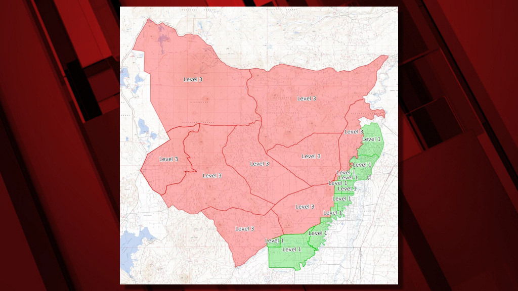
With improving conditions on the Little Lava Fire and continued progress, the Deschutes County Sheriff’s Office, in coordination with the Sunriver Police Department and fire managers, are adjusting evacuation levels.
Summary of evacuation changes:
Most areas previously Level 1 (Be Ready) are returned to normal. This area includes:
- West of Hwy 97 south of Lava Butte and adjacent to Sunriver, south to Vandevert Rd including the Sunriver Business Park, Caldera Springs, Crosswater and Vandevert Ranch.
- Oregon Water Wonderland and Big River Drive area north of South Century Dr (FS Rd 42).
All areas previously Level 2 (Be Set) are reduced to level 1. This area includes:
- Areas west of the Deschutes River from Fall River Estates north to Spring River Rd, including Fall River Estates, River Forest Acres, River Meadows, Stage Stop Meadows, and Deschutes River Recreational Homesites.
- Areas north of Spring River Rd west of the Deschutes River including Besson Rd area and Spring River Acres.
- Sunriver
All Level 3 (Go Now) areas will remain the same.
Current Evacuation Levels are as follows:
Current Level 3 (Go Now):
Deschutes National Forest south of FS Rd 46 (Century Drive), west of FS Rd 41 and the Deschutes River (South of Benham Falls Road), north of FS Rd 40, and east of the of the north/south section of Century Drive (Excluding Elk and Lava Lake Resorts, cabins and campgrounds). This area includes: Mt. Bachelor, Wanoga Butte and snow park, Kapka Snow Park, Edison Snow Park, Todd Horse Camp, Sparks Lake, Devils Lake.
Areas West of the Forest Boundary, north of FS Rd 42 (South Century Dr), east of FS Rd 4240, and north to the FS Rd 40 (and adjacent Level 3 Evacuation areas. This area includes Pistol, Sitkum and Anns Buttes.
Level 3: Means “GO” evacuate now. Leave immediately! Danger to your area is current or imminent, and you should evacuate immediately. If you choose to ignore this advisement, you must understand that emergency services may not be available to assist you further. DO NOT delay leaving to gather any belongings or make efforts to protect your home. This will be the last notice you receive.
Current Level 2 (Be Set):
There are no current Level 2 (Be Set) areas.
Current Level 1 (Be Ready):
- Areas west of the Deschutes River from Fall River Estates north to Spring River Rd, including Fall River Estates, River Forest Acres, River Meadows, Stage Stop Meadows, and Deschutes River Recreational Homesites.
- Private property north of Spring River Rd west of the Deschutes River, and east of the Deschutes National Forest Boundary including Besson Rd area and Spring River Acres.
- Sunriver
Level 1: Means “BE READY“ for potential evacuation. Residents should be aware of the danger that exists in their area, monitor emergency services websites and local media outlets for information. This is the time for preparation and precautionary movements of persons with special needs, mobile property and (under certain circumstances) pets and livestock. If conditions worsen, emergency services personnel may contact you via an emergency notification system.
Current maps including evacuation areas can be found at:
https://deschutes.org/emergency
For fire information, you can visit the Central Oregon Fire Information site at:
--
Bachelor Complex, Flat Top, and Firestone Fires Update 09-12-2024
Northwest 3 Complex Incident Management Team
Lonnie Click, Incident Commander
September 12, 2024
Bachelor Complex, Flat Top, and Firestone Fires Update
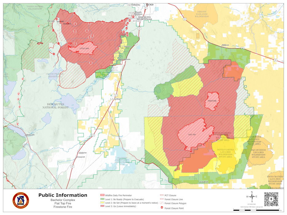
Quick Facts: Bachelor Complex
Size: 10,332 acres Start Date: Sept 8, 2024 Location: Mt Bachelor, 20 miles SW Bend, OR
Personnel: 248
Quick Facts: Firestone & Flat Top Fires
Firestone Size: 8,787 acres Start Date: Sept 6, 2024 Location: North of Fort Rock, OR
Flat Top Size: 30,643 acres Personnel: 116
Yesterday, firefighters continued to work on suppressing the Bachelor Complex, Flat Top and Firestone Fires which saw slow to moderate growth on Wednesday due to cooler, wetter weather. This decrease in fire activity allowed crews to focus efforts on putting in containment lines on the fires. A helibase was established in Sunriver to support aerial resources. Firefighting operations include connecting roads with dozer lines and handlines both directly adjacent to the fire and further away, where indirect strategies are more effective. No new fires were reported on Wednesday. Today, firefighters will work on structure protection in the vicinity of Sheridan Mountain and west of Sunriver. Firefighters will continue to establish and secure containment lines around the Bachelor Complex, Flat Top, and Firestone Fires. Aerial resources will continue to help with suppression efforts.
Bachelor Complex: The Bachelor Complex is a group of about 30 fires that range from one tenth of an acre to over 9,500 acres, for a total of 10,332 acres. The cooler wet weather slowed fire spread on the Little Lava Fire and crews capitalized on the opportunity, making good progress toward securing the fire’s edge east of Forest Service Road 45 with dozer line. Moderated fire behavior is expected again today, and firefighters will continue those efforts. They are using Forest Service Road 4525 to connect roads and trails to serve as containment lines. The Backside, 911, and 892 Fires are higher up on the Cascade Crest and received almost one tenth of an inch of precipitation yesterday. Today, firefighters will continue to secure and mop up the Backside Fire and smokejumpers continue to mop up the 911 Fire.
Flat Top Fire: Yesterday, firefighters were able to directly engage putting fire on the ground to help secure control lines on the north and northeast sides of the fire. The crews working overnight reported no increase in size for this fire. Today, firefighters will continue work on securing the north side and conduct lighting operations off of Forest Service Road 22 to strengthen containment lines by consume vegetation between the line and the active edge of the fire.
Firestone Fire: Yesterday, firefighters were able to get most of the western edge of the fire secure. They used hand and dozer lines to stitch together a containment line with the existing road system. Work will continue securing the north side of the fire.
Safety: With increased fire traffic, everyone in the area is reminded to drive slowly and carefully in evacuation areas. If you don’t need to be in the area, please stay clear to allow firefighters plenty of time and space to work.
Weather and Fire Behavior: Bachelor Complex fires received more rain than Flat Top or Firestone Fires yesterday. The amount of precipitation on the Little Lava Fire was not enough to have long-lasting effects. Vegetation beneath the tree canopy remains dry and ninety percent of this fire has an active perimeter. The Backside, 892, and 911 Fires received more moisture which significantly slowed fire spread. Based on the weather outlook for the higher elevation fires on the Bachelor Complex, fire behavior analysts predict another mild day for fire behavior. On the Flat Top and Firestone Fires, stumps and logs are expected to continue burning while grasses and shrubs aren’t expected to dry out enough to be receptive to ignition until this afternoon. Scattered showers are expected throughout day over all fires.
Evacuations: Emergency management and fire officials are closely coordinating and adjusting evacuation levels as needed. Level 3 evacuations mean “Go Now,” Level 2 means “Be Set,” and Level 1 means "Be Ready.”
To view current evacuation levels, please visit the Deschutes County Emergency Information Interactive Map at: http://www.deschutes.org/emergency. For Lake County evacuation information, please visit: https://www.lakecountyor.org/flat_top.php
Closures: There are two closure areas on the Deschutes National Forest for these fires. View the orders on the Deschutes National Forest site at: https://www.fs.usda.gov/alerts/deschutes/alerts-notices.
Facebook
https://www.facebook.com/deschutesnationalforest/
InciWeb
https://inciweb.wildfire.gov/incident-information/ordef-bachelor-complex-fires
https://inciweb.wildfire.gov/incident-information/ordef-flat-top-and-firestone-fires
Fire Information Line: 541-249-9829, 8:00 a.m. to 8:00 p.m.
--
Wiley Flat Fire update:
Firefighters Go Direct on the Western Edge
Daily Update September 12, 2024
Fire Information Phone: 541-208-7108 (8 a.m.- 8 p.m.)
Email: 2024.wileyflat@firenet.gov
Acres: Wiley Flat – 29,904; 48% contained Hawley Ridge – 793; 100% contained
Location: Wiley Creek: about 10 miles southeast of Post, Oregon off Highway 380.
Start Date: September 2, 2024,
Personnel: 566
Resources: 17 crews |19 engines | 16 dozers | 13 water tenders | 3 masticators | 5 skid steers | 1 ambulance | 2 helicopters
Highlights: The Ochoco National Forest has expanded the Wiley Flat Fire Closure area to the west.
The eastern edges of the fire remains in patrol status. Northern control lines near Shotgun Creek are now contained. Crews and heavy equipment made progress constructing direct line along the western and southwestern edge of the fire, which will continue today. Helicopters supported firefighting efforts with bucket drops along the western edge. The remaining edges of the fire will continue to be mopped up and patrolled.
Weather:
• Today: Mostly cloudy in the morning, becoming partly cloudy in the afternoon. There is a slight chance of thunderstorms this morning. Temperatures will remain cooler with highs near 60. Winds will be northwest 7 to 14 mph, with gust up to 20 mph in the morning. Minimum relative humidity will be near 55 percent.
Evacuations: The following evacuations are in effect:
LEVEL 3: SE Maury Road west to SE Newsome Creek Road from Crooked River south to the Forest boundary.
LEVEL 2: SE Newsome Creek Road west to SE Conant Basin Road area south of Crooked River. SE Maury Road east to SE Camp Creek Road from Hwy 380 south to Forest Boundary.
An evacuation map is available online through the Crook County Emergency Management Office website.
The Red Cross evacuation shelter is in the Carey Foster Hall at Crook County Fairgrounds SE Lynn Blvd. Prineville, OR 97754. Information number: 1-800-RED-CROSS
Importance of Fire Prevention: All public lands in Central Oregon are in Stage 2 Public Use (Fire) Restrictions. All open flames, including woodstoves and charcoal briquette fires, are prohibited. In times of high fire danger, it is crucial for everyone to follow prevention measures to avoid additional strain on overburdened resources.
Fire Restrictions and Closures: These areas are closed to all uses, including recreational activities, for public and firefighter safety. The Ochoco National Forest has implemented temporary closures for the Paulina and Lookout Mountain Ranger Districts. The Bureau of Land Management has issued a temporary closure for portions of public lands in Crook and Grant Counties.
More Information:
Smoke Outlook: https://outlooks.airfire.org/outlook/929bfe8f
InciWeb: https://inciweb.wildfire.gov/incident.../orocf-wiley-flat Facebook: Facebook.com/2024Wiley Flat Fire
Central Oregon Wildfire Information: https://centraloregonfire.org/
--
Rail Ridge Fire update:
Rail Ridge Quick Facts
| Acres: 161,675 | Crews: 11 |
| Containment: 12% | Engines: 130 |
| Detection Date: Sept 2, 2024 | Dozers: 35 |
| Cause: Lightning | Aircraft: Available as needed/as air clears |
| Total resources: 1,053 | |
Contact us
Phone: 541-208-7111
Email: 2024.railridge@firenet.gov Facebook: Rail Ridge Fire - Oregon 2024
Inciweb: https://inciweb.wildfire.gov/incident-information/orocf-rail-ridge
LinkTree: https://linktr.ee/RailRidgeFire
Closures and Evacuations
Closures: The Forest Service and BLM have implemented partial closures due to the Rail Ridge Fire and Crazy Creek Fire, for all uses. For more details and closure maps, visit the Ochoco National Forest, Malheur National Forest, and BLM web pages.
Evacuations: Shelters are available to evacuees. For up-to-date evacuation information, please visit:
- Crook County: Crook County Emergency Management website and Crook County Sheriff’s Office Facebook page.
- Wheeler County: Visit the Wheeler County Sheriff’s Office Facebook page for real-time updates.
- Grant County: Grant County Emergency Management Facebook page.
Operational Update:
There is a community meeting tonight at the Paulina Community Center, at 5 p.m.
Address: 70299 Paulina City Rd, Paulina, OR 97751
Resources continue to prioritize efforts to protect local communities, structures and land. Today, the focus is on boxing in the northwest edge of the fire by completing control line to ensure the fire doesn’t flank out and impact nearby communities. In the Battle Creek area, heavy equipment will continue to address access issues, while considering long-term impacts on road conditions.
In the Guyon Basin, resources continue to tie control lines together across the South Fork area, working to keep the area behind Dayville secure. Oregon State Fire Marshal (OSFM) task forces will extend mop up around structures in this area, working down to the South Fork Road. Along Fields Creek/FSR 21, road prep work continues, and firefighters will be looking for opportunities to engage directly with the fire. Multiple air resources will be available to assist with suppression efforts throughout the day, weather permitting.
In the Morgan Mountain area, the focus remains on completing containment lines around the slop fire. Within the fire perimeter, there is an unburned island near Sugarloaf Mountain that crews will be assessing for potential firing operations. On the south and southwest portions of the fire, nominal fire behavior has been observed and crews will continue to complete mop up and hold control lines, working towards Wolf Mountain and tying line into road systems out to the west. OSFM resources have wrapped up structural triage and prep on the south end and will be assisting wildland partners with mop up along control lines.
Wildland crews will be engaged in mop up throughout the fire area, focusing on heat still holding in the junipers. These trees hold considerable heat in their root systems and make them susceptible to torching. By addressing these types of hazards, the fire line becomes more secure and long-term stability on the incident is improved.
Overnight, resources focused on maintaining the progress achieved during day shift. The fire area received wetting rains until about midnight, resulting in minimal fire behavior that did not challenge any containment lines. Crews monitored, patrolled and held established control lines and worked to keep key access roads open against snags and hazard debris. This has been especially challenging for crews working along FSR 2150, which provides vital access to critical communications infrastructure at Aldrich Lookout. Battle Creek Road had to be shut down due to heavy rainfall during the night.
Yesterday, favorable weather contributed to reduced fire activity, and minimal growth was noted. The Dayville, Morgan Mountain, and Battle Creek areas were prioritized. Near Dayville, OSFM crews mopped 100’ out from structures that were near the fire line. Crews took advantage of cooler temperatures to secure the area behind the community of Dayville, tying together control lines and mopping up, while OSFM crews ensured areas around structures were cool and secure.
At the slop over near Morgan Mountain, containment lines were extended, and very little fire behavior was observed. As wildland resources installed line and engaged with the fire there, OSFM task forces provided structure protection to homes in the area and assisted with monitoring established line. The area is now about 85% lined.
Near Battle Creek, heavy equipment was used to improve access points for crews to reach fire within the wilderness area that has been slowly crawling in the lighter fuels. Resources in this area have been hampered by access and have been using both direct and indirect tactics.
On the southern edge of the fire, crews remained in patrol mode and conducted mop up operations. Due to multiple days of minimal fire growth during the night, several hand crews are being reallocated to day shift to support incident objectives.
With the reduction in fire activity and the significant preparation work that has been completed, OSFM is able to downsize the number of task forces assigned to the Rail Ridge Fire. Cooperative efforts of resources have contributed to significant progress and fire activity has been minimized in the vicinity of structures. Task forces from Washington state and Yamhill County will return to their home agencies today, leaving six OSFM task forces (30 apparatus), assigned to the fire. These remaining crews will continue to provide around the clock structural protection, with a heavy presence in Dayville, South Fork Road, Fields Creek, and Morgan Mountain areas.
Weather:
Showers continued into the night, providing wetting rains over the fire. Cool conditions will continue today, with seasonably cool and dry conditions expected across the fire through the coming weekend.
Related Links:
--
Shoe Fly Fire update:
| SHOE FLY FIRE Daily Update: September 12, 2024 | Fire Information Links: https://linktr.ee/odfteam1 Phone: (206)473-9132 Email: IMT1.FireInfo@ODF.oregon.gov |
FIRE
AT A GLANCET
Total Size: 26,774 acres
Total Containment: 53% Cause: Lightning
Estimated Cost:
$11,336,899
County Evacuations
No evacuations related with the
Shoe Fly Fire. Road Closures
For road closures, visit:
https://www.tripcheck.com
Fire Restrictions
ODF: www.oregon.gov/odf/fire/pages/restrictions.aspxBLM: www.blm.gov/programs/public-safety-and-fire/fire-and-aviation/regional-info/oregon-washington/fire-restrictions All Resources Hand Crews: 28Engines: 29Water Tenders: 21Dozers: 8Helicopters: 6Total Personnel: 811 ODF Incident Commander:
Incident Management Team 1
Evacuation notices lifted, rain aids in mop up
MITCHELL, Ore. – All evacuation notices associated with the Shoe Fly Fire have been cancelled by Wheeler County Sheriff, Emergency Management and the Fire Defense Board Chief as of Wednesday morning. The fire continues to hold within containment lines.
Rain and thunderstorms passed over the fire area on Wednesday and overnight into Thursday, dropping nearly a quarter inch of rain. This rain was beneficial in some parts of the fire but may not have penetrated the canopy or through the thick duff layer in other areas. Through the mop up process, firefighters will be looking for smoldering fire in the duff and under other hot spots.
The southeast and northwest portions of the fire are being patrolled for visible signs of smoke or flames along the perimeter. Resources working in this area are also completing suppression repair work. This work is being done for public safety, to protect water quality and limit soil erosion.
Resources are being shifted from other parts of the fire to the Girds Creek and Keyes Creek area along the southwest flank and to the northeast part of the fire to speed up the mop up work on these areas.
Over the next few days, firefighters will focus efforts on attaining 300 feet of cold black adjacent to the fireline and ensuring there are no hazard trees which could fall across the fireline or pose a safety hazard for firefighters or the public. Jackpots of fuel adjacent to the fireline are being masticated to reduce the possibility of embers igniting them in the future. Wednesday night was the last night shift for the incident. Crews will be reassigned to work the day shift or released from the incident. As containment increases, resources are being released for reassignment to other incidents or to return home.
--
Willamette Complex North Update
Boulder Creek, Ore, Linton Creek, Pyramid, 374, and Roundtop fires
Date: Thursday, September 12, 2024
Willamette Complex North Facebook Page: https://www.facebook.com/profile.php?id=61565845313387
Email: 2024.WillametteComplex.North@firenet.gov Information line: 541-208-1262 Hours: 8 a.m. to 8 p.m.
Overview: Rain of up to an inch fell over the complex in the last 24 hours. This decreased fire behavior with minimal fire activity overnight. Limited spread is expected today, with some smoke visible. The Boulder Creek Fire remains the top priority. A road closure continues for a section of OR 242, and a portion of OR 126 remains closed while conditions are evaluated. The Boulder Creek Fire reached OR 126 and crews continue to clear hazard trees. Today the rain will taper off with clouds, light winds, and highs in the mid-50s. Fire crews are using the day as an opportunity to make additional progress on containment lines.
Boulder Creek Fire Evacuation Notices
LEVEL 3 (GO NOW) EVACUATION NOTICE: Scott Creek Road
LEVEL 1 (BE READY) EVACUATION NOTICE: South of Highway 126 from milepost 53.5 east to Scott Creek Road and Horse Creek Road east of Foley Springs, Foley Springs, Forest Service Road #302, Belknap Springs Road South, Camp Yale Road, Yale Lane, North of Highway 126 East from the east end of Drury Lane to the end of North Belknap Springs Road
Linton Creek Fire Evacuation Notices
Level 3 (GO NOW) EVACUATION NOTICE: Pacific Crest Trail near Linton Meadow and near Husband Lake
Evacuation Notice Source: Visit www.LaneCountyOR.gov or use this link.
Boulder Creek: 501 acres, 0% contained
Located 5 miles east of McKenzie Bridge. Structure protection work has been underway. Crews are going direct on the fire where possible and safe.
Ore: 3461 acres, 44% contained
Located 7 miles northeast of Blue River. Crews continue to improve containment lines. Pockets of unburned fuel remain that could still pose minimal threat to containment lines.
Linton Creek: 1288 acres, 0% contained
Located in the Three Sisters Wilderness northeast of Eileen Lake. Rainy weather helped decrease fire behavior.
Pyramid Fire: 1,311 Acres, 98% contained
East of Middle Santiam Wilderness. Hauling out fuels to secure containment lines continues.
374: 47 acres, 0% contained
This fire is also in the Three Sisters Wilderness, northwest of Packsaddle Mountain. Smokejumpers are assigned to the fire and trails are being prepped as containment lines.
Roundtop: Near the 374 Fire and Little Roundtop Mountain. It was kept at a quarter acre and near full containment.
Road Closures: Due to the Boulder Fire, OR 126 is closed between mileposts 13 and 19.5 (intersection with OR 242). OR 242 remains closed to all traffic indefinitely between the intersection with OR 126 and the Dee Wright Observatory (mileposts 55 to 75), in the area of the Linton Creek Fire. Use an alternate route; do not divert onto forest roads to avoid closures. Check for updates at: https://tripcheck.com/
Willamette National Forest Area Closures: Due to increased fire activity in the McKenzie River Ranger District, the Linton Creek closure area was expanded to include Boulder Creek, 374, Roundtop, as well as other fires on the Middle Fork Ranger District including Young Grasshopper and Lowell Creek fires. Source: https://www.fs.usda.gov/detail/willamette/alerts-notices/?cid=fseprd552029
--
09/12/2024 - 09:30
Willamette Complex South & Red Fire Update
Red, 208, Moss Mountain, Coffee Pot, Tire Mountain, McKinley Creek and Chalk Fires
Date: Thursday, September 12, 2024 Fire Causes: Lightning
Email: 2024.willamettecomplex@firenet.gov Information Phone Line: 541-208-1742
Willamette Complex South: Total Personnel: 674 | Total Willamette Complex South Acres: 23,197
InciWeb: https://inciweb.wildfire.gov/incident-information/orwif-willamette-complex-fires-south
Facebook: https://www.facebook.com/WillametteComplexFires/
Red Fire: Total Personnel: 68 | Total Red Fire Acres: 1,732
InciWeb: https://inciweb.wildfire.gov/incident-information/ordef-red-fire
Facebook: https://www.facebook.com/2024RedFireOR/
Summary
Yesterday’s passing weather system provided an opportunity to reevaluate fire behavior and determine operational needs. Fire managers continue to prioritize the minimization of acres burned. With fire behavior moderated by the rain, firefighter operations began shifting from line preparations to repair. However, some work will continue to connect existing segments of fireline. Rain also halted heavy equipment operations, including road repair, in areas where soils were saturated and posed a greater risk to resources than the fire conditions demanded. Where conditions allowed, slash and logs were removed from previously prepped roads.
Red Fire (1,732 acres, 0% containment)
Structure preparations were completed yesterday with the installation of several portable water holding tanks. All deployed structure protection equipment will continue to be checked and maintained in the event of unforeseen changes in fire behavior. Extensive rain halted firefighter operations on the reinforcement of indirect line in the area. The Whitefish Creek Trail was lined with 9,000 feet of hose. This hoselay serves as an indirect line while fire behavior and resource needs in this area are being reevaluated.
208 Fire (8,843 acres, 0% containment)
The fire remains north of Forest Service Road (FSR) 29 where burning operations occurred last Sunday. Fire growth is gradual in the direction of indirect line along FSR 23 to the northwest and FSR 21/2154 to the south. Indirect handline construction meant to protect private timber is complete from FSR 23 to FSR 423.
Moss Mountain Fire (2,133 acres, 8% containment)
Primary and contingency lines along FSR 23, 2120, 490, and 2309 are being patrolled. The focus remains on confinement of the fire's northward spread to minimize burned acreage. Work will proceed today on suppression where needed. Additionally, repair activities will continue as crews evaluate how the rain impacted fire activity.
Chalk Fire (5,987 acres, 86% containment)
Firefighters remain engaged in repair activities. Crews continue to improve indirect line by removing and chipping vegetation. Additionally, the firefighters will continue to patrol and monitor existing containment lines.
Weather and Fire Behavior
Yesterday, a low-pressure system brought consistent rainfall to the area. On average there was about a 0.50" of rain across the area. This moderated fire behavior by bringing moisture to previously dried fuels. Looking ahead, elevated relative humidity and persistent cloud cover and smoke are expected through early next week. This cooling trend will continue to reduce fire behavior to creeping and smoldering.
Closures, Fire Restrictions, and Evacuations
- For closure information, visit: https://tinyurl.com/RedFireClosues2024 & https://tinyurl.com/WillFireClosures2024.
- For fire restrictions, visit: https://tinyurl.com/DesFireRestrictions2024 & https://tinyurl.com/WillFireRestrictions2024.
- For current Temporary Flight Restrictions (TFR), visit: http://tfr.faa.gov.
- The Level 1 – BE READY to Evacuate notice remains in effect for the Red Fire. For more information or to sign up for alerts, visit: www.klamathcounty.org/300/emergency-management.
