Deschutes National Forest expands emergency fire closure areas around Bachelor Complex, Flat Top and Firestone fires

BEND, Ore. (KTVZ) — The Deschutes National Forest announced Thursday it has updated and enlarged two temporary emergency fire closure areas on the Bend-Fort Rock Ranger District due to the Bachelor Complex, Flat Top Fire and Firestone Fire.
The Bachelor Complex includes the Little Lava Fire and Backside Fire, as well as 30+ smaller fires within the area around Mt. Bachelor.
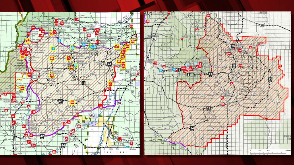
Bachelor Complex | Temporary Emergency Fire Closure
The emergency closure order for the Bachelor Complex of fires includes the following closed locations. Please see the full closure order map below.
The following developed and dispersed recreation sites are temporarily closed:
- AC/DC Shelter
- Aspen Boat Launch and Trailhead
- Benham Falls East Day Use
- Benham Falls West Trailhead
- Besson Day Use
- Big Eddy Day Use
- Corral Swamp Trailhead
- Dillon Falls Day Use
- Edison Shelter
- Edison SnoPark
- Green Gate Trailhead
- Kapka Butte SnoPark
- Kwohl Shelter
- Lava Island Day Use Area
- Lucky Lake Trailhead
- Meadow Day Use Area
- Mt. Bachelor Resort
- Quinn Creek Trailhead
- Quinn Meadow Horse Camp
- Rimrock Trailhead
- Rock Viewpoint
- Royal Flush Trailhead
- Sheridan Shelter
- Six Lakes Trailhead
- Slough Day Use
- Storm King Trailhead
- Todd Creek Horse Camp
- Todd Creek Trailhead
- Tyler’s Trailhead
- Wake Butte Trailhead
- Wanoga SnoPark
- Wanoga SnoPlay
Roads in the area:
- All National Forest System Roads found within the area closure are closed. Cascade Lakes Highway (NFSR 46) and NFSR 42 will remain open for public use.
Firestone & Flat Top Fires | Temporary Emergency Fire Closure
An emergency closure for the Firestone and Flat Top Fires burning 26 miles east of La Pine is now in effect. Please see the full closure order map below.
The following developed and dispersed recreation sites are temporarily closed:
- Pine Mountain Observatory
- Pine Mountain Campground
- NFSR 25 OHV Trailhead (RD 25 Trailhead)
- NFSR 2510 OHV Trailhead (Rd 2510 Trailhead)
- Camp 2 (II) OHV Trailhead
- Groundhog OHV Trailhead
- China Hat Campground
- South Lava OHV Trailhead
- South Ice Cave Picnic Area
Roads in the area:
- All National Forest System Roads found within the area closure are closed. Oregon Outback Scenic Byway (SR 31) will remain open for public use. NFSR 18 north and south of the closure boundary will remain open for public use.
For information regarding temporary emergency closures on the Deschutes National Forest, visit fs.usda.gov/alerts/deschutes/alerts-notices.