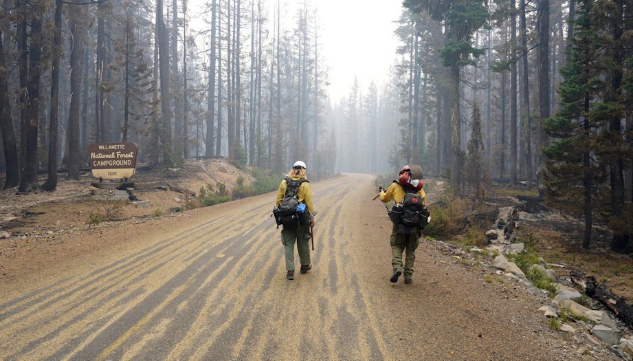
Rain, cooler weather help army of firefighters bring 113,000-acre Cedar Creek Fire back to 11% containment

OAKRIDGE, Ore. (KTVZ) -- A weekend of cooler weather and some widespread rainfall helped a still-growing army of nearly 2,600 firefighters on the 113,000-acre Cedar Creek Fire conduct burnout work and build fire lines, to reach their first containment figure in days, at 11%, officials said Monday
The cost of that fight has grown too, of course, to nearly $72 million as of Monday morning, according to the National Interagency Fire Center.
Here's the Monday morning update from fire officials:
Cedar Creek Fire
September 19, 2022
Daily Update at 9:00 AM
Cedar Creek Fire Quick Facts
Size: 113,322 acres
Contained: 11%
Start Date: August 1, 2022
Origin: 15 miles east of Oakridge, Oregon
Cause: Lightning
Total personnel: 2,577
Resources: 92 engines, 58 crews, 105 heavy equipment, 12 helicopters
Status: Higher humidity and precipitation minimized fire growth on Sunday. The fire is now 11% contained. The containment line includes the west side of the fire between FS 24 and Fifth Creek, the stretch from Charlton Lake west to the shore of Waldo Lake, and the north and west shores of Waldo Lake.
The West Zone of the fire is currently burning with low intensity creeping, and smoldering. Fire spread is occurring in areas with deep, dry litter and heavy fuels. The East Zone is experiencing fire behavior including creeping, smoldering, and single-tree torching. Fire growth is minimal. Sheltered heat may reemerge after the rain if fuels continue to be dry enough.
West Zone Operations: Moderated conditions allowed firefighters to secure the fireline in the area previously burned during burn-out operations. Crews secured the containment line by cutting snags (dead or fire weakened trees) that pose a threat to the fireline and to the safety of firefighters. Firefighters are extinguishing hot spots along the western edge where burning operations occurred the past few days. On northern edge of the fire near FS 19, firefighters used both mechanized equipment and hand crews to continue vegetation thinning and chipping in preparation of the fire backing down to the road.
Protecting the communities of Oakridge, Westfir, and High Prairie remains the top objective for firefighters. Along the south and southwest areas of the fire, crews will take advantage of opportunities to complete firing operations when conditions allow. Using a combination of hand lighting along the fireline and aerial ignitions near Kwiskwis Butte, firefighters will continue to bring the main fire toward the control line to reduce ground vegetation and improve the effectiveness of the control line. Crews will remain flexible through the day to move firefighters as needed to efficiently take advantage of weather windows when burning operations may be feasible.
East Zone Operations: Hotshot crews have contained the area from Charlton Lake west to Waldo Lake and are securing the east side of Charlton Lake to the Cascade Lakes Highway. On the east side of Waldo Lake, crews have completed 6 miles of fuel break, 75 feet deep, along FS 5896 and FS 5897 from Charlton Lake to Highway 58. More than 170 structures have been assessed and 90% of the protection work has been completed. In addition, most of the protection work has been completed in campgrounds; those completed include: North Waldo, Islet, Cultus Lake, Little Cultus Lake, Davis Lake, Reservoir, Osprey Point, North Davis, North Lava Flow, Quinn, Rock Creek, Trapper Cove, Gold Lake, and Lucky Lake Campground is in progress.
Crews continue to work FS 4668 and FS 4660 to create a break between Odell Lake, Davis Lake, and the Cascade Lakes Highway. Between Little Cultus Lake and Deer Lake, crews are brushing, chipping, and removing snags along FS 640 to protect Cultus Mountain from future fire advancement. Final clean up is happening on the FS 700 fuel break connecting Little Cultus Lake and the Cascade Lakes Highway. Work continues along the west side of the Cascade Lakes Highway to create a shaded fuel break, working in sections and extending further north to Lava Lake.
Weather: Showers and some thunderstorms crossed the fire area with rain amounts ranging from 0.3 to 0.5 inches at the start of Sunday. Inversions also led to dense smoke and fog through areas of the West Zone of the fire. Monday may bring some additional showers, but overall, the day is forecasted to be a little bit warmer with lower humidity and ridgetop winds. In the East Zone, today is expected to be mostly clear with a chance of scattered afternoon showers. Rain is more likely on Tuesday and into Wednesday with a warming trend later in the week.
Evacuations: An updated map of the evacuation areas is available at www.LaneCountyOR.gov/CedarCreek. Sign-up for emergency mobile alerts by going to oralert.gov. Please check with Lane County Sheriff’s Office at 541-682-4150 and Deschutes County Sheriff’s Office at 541-693-6911 for updates and changes. Lane County residents can use the Lane County Sheriff’s Office Flash Alert site for information to support insurance claims for reimbursement for lodging https://flashalert.net/id/LaneSheriff.
Closures: Elijah Bristow State Park and Dexter Boat Launch are closed to the public since they are being used by firefighters. The Deschutes National Forest and Willamette National Forest both have closures in effect to protect the public and firefighters. Please visit Willamette National Forest and Deschutes National Forest for the most recent closure orders and maps. A Temporary Flight Restriction (TFR) is in place. The use of drones is prohibited in the fire area, please make it safe for our firefighters to use aircraft on the fire. Pacific Crest Trail hikers should visit pcta.org for current information. See a map of the fire area with both forest closures here: https://inciweb.nwcg.gov/incident/map/8307/0/137083
Restrictions: Fire restrictions are in place on the Willamette National Forest and Deschutes National Forest.
Smoke: For current conditions, see Fire.airnow.gov, oakridgeair.org, and LRAPA - Today's Current Air Quality. Smoke Forecast Outlooks are available at https://outlooks.wildlandfiresmoke.net/outlook.
Online: https://inciweb.nwcg.gov/incident/8307/ | https://www.facebook.com/CedarCreekFire2022/ |
YouTube: https://www.tinyurl.com/cedarcreekfireyoutube
Fire Information Line: 541-201-2335, 8:00 AM – 8:00 PM |
Email: 2022.cedarcreek@firenet.gov