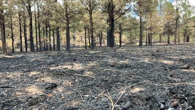
Many acres of Calf Canyon Hermits Peak burn scars ‘water repellent,’ concerns with monsoons coming

As more acres of the Calf Canyon Hermits Peak fire are drowned out
By Stella Sun
Click here for updates on this story
MORA, New Mexico (KOAT) — As more acres of the Calf Canyon Hermits Peak fire are drowned out, teams of soil and water experts are assessing the damage and possible threats to New Mexico communities with monsoon season coming.
Miles from the heart of Mora, wildlands scorched from the Calf Canyon Hermits Peak fire. All eyes turn to burn scars, as New Mexico dives into Monsoon season.
“What we’ll see from that when the rains start is flooding. We’ll see erosion,” Micah Kiesow, the team leader with the Burn Area Emergency Response teams, said.
The BAER team consists of engineers, hydrologists and soil specialists, among others. They survey the burn scars determining what areas have low, moderate and high burn severity.
“One of the things we do, is we get down and take a look at what the forest floor looks like after the fire,” Kit Macdonald, a soil specialist with the BAER team, said.
Macdonald said the higher the burn severity, the more water repellent the soil becomes.
“On those high severity areas, we’re definitely going to see accelerated runoff, move rocks and boulders, and logs that are left out there burned, and create problems for infrastructure and water quality,” Macdonald said.
When the monsoon downpours arrive, KOAT meteorologists say 0.25 inches of rainfall can trigger flash flooding. Of the areas the BAER team has assessed, nearly half of the scorched soil is considered water repellent.”
“That information will help us assess what roads might be at risk, what trails might be at risk,” Kiesow said.
According to the National Weather Service, “locations that are downhill and downstream from burned areas are highly susceptible to Flash Flooding and Debris Flows, especially in and near steep terrain.”
Kiesow described many acres of the burn-scarred land they’ve assessed as a parking lot with a 60% slope. Before the fire ripped through, Kiesow said the soil was like a sponge and would absorb more rainfall.
The BAER team will make a risk assessment of the areas they assess and provide recommendations.
Please note: This content carries a strict local market embargo. If you share the same market as the contributor of this article, you may not use it on any platform.