Gov. Brown visits fire-hit S. Oregon; Lionshead Fire closure area reduced
(Update: Adding Gov. Brown visit to S. Oregon; Lionshead Fire closure area reduced; Holiday Farm Fire victim identified)
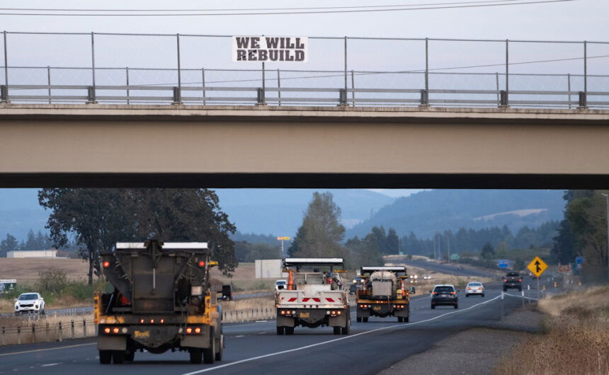
SALEM, Ore. (KTVZ) -- More than 7,500 firefighters from nearly 40 states and three Canadian provinces worked in improved weather conditions Monday to get lines around several major wildfires across Oregon, two weeks after east winds fueled devastation over a wide area.
The Oregon Office of Emergency Management's daily update on Monday remained at nine wildfire-related fatalities and five people still missing. The tally now stands at 2,268 homes destroyed, along with 1,556 other structures.
On Monday, the Lane County Sheriff's Office identified a Holiday Farm Fire victim found dead Sept. 11 in a home off Goodpasture Road in Vida as David Perry, 59, of Vida. "Our thoughts go out to Perry's family and friends as they grieve," Sgt. Carrie Carver said.
More than 2,500 remain sheltered and nearly 3,400 have signed up for FEMA individual assistance.
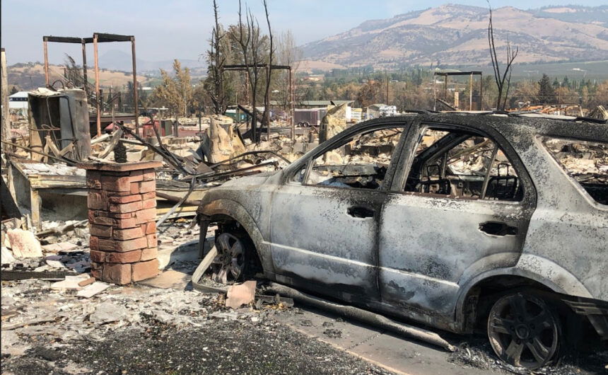
Gov. Kate Brown on Monday visited Southern Oregon, where she toured areas of fire damage and met with local officials, firefighters, evacuees and families impacted by the fires, and community partners helping with recovery efforts.
The governor visited areas damaged by the Almeda Drive Fire, received a fire briefing from the Incident Command Post, met with firefighters and law enforcement officers at Jackson County Fire District 5, met with Oregon National Guard members in the field, visited an evacuation site that has been set up at Home Depot, and met with local community partners representing health equity, schools, law enforcement, and social justice.
“Today I surveyed the devastation caused by the Almeda Fire," Brown said. "From seeing it firsthand and talking with evacuees, the losses in Medford, Ashland, Phoenix, and Talent are hard to comprehend. My priority is to secure the resources necessary to help rebuild an even stronger southern Oregon."
The governor was joined by state Rep. Pam Marsh, National Guard Adjutant General Michael Stencel and Oregon Office of Emergency Management Director Andrew Phelps.
The Oregon Department of Forestry said Monday it is closely monitoring 10 major fires in Oregon, down from 17 originally (see table below for details). Fires are removed from the list when they are 100% lined and fire managers are confident in their progress toward containment.
There have been more than 7,500 personnel assigned to these fires, not including many of the government employees, land owners, forestland operators and members of the community who are contributing every day. There have been resources from 39 states and multiple Canadian provinces in this fight alongside Oregonians.
About 1 million acres have burned in Oregon since the start of this year, which is nearly double the 10-year average of approximately 557,811.
| Fire name | Acres burned (est.) | Containment | Location |
| Lionshead | 198,647 | 13% | 20 miles W of Warm Springs |
| Beachie Creek | 192,764 | 38% | 15 miles N of Detroit |
| Holiday Farm | 170,637 | 17% | 3 miles W of McKenzie Bridge |
| Riverside | 137,880 | 25% | 2 miles SE of Estacada |
| Archie Creek | 131,598 | 41% | 20 miles E of Glide |
| Brattain | 50,447 | 52% | 8 miles S of Paisley |
| Slater | 42,214 in Oregon | 18% | SE of Cave Junction (also in No. California) |
| S. Obenchain | 32,671 | 65% | 5 miles E of Eagle Point |
| Two Four Two | 14,473 | 77% | W/NW of Chiloquin |
| Thielsen | 9,689 | 22% | E of Diamond Lake |
More information
- ODF wildfire blog and Significant Fire Potential Map
- Northwest Coordination Center – Regional Update and National Situation Report
- Inciweb (information on individual incidents)
Deschutes National Forest Reduces Lionshead Fire Closure Area
Favorable weather and firefighting efforts lead to increased access to Metolius Basin
Sisters, Ore.- Favorable weather conditions and significant firefighting efforts on the Lionshead Fire prompted the Sisters Ranger District to decrease the Lionshead Fire Closure Area. Beginning Monday, the following areas are now open for public access:
Roads
- FS Road 11 from Highway 20 north to Perry South
- FS Road 14 road system, including Allingham Bridge
Trails
- Upper Black Butte Trail (#4026)
- FS Road 1499 from Lower Bridge Campground to Monty Campground (non-motorized access only)
Day Use Areas:
- Perry South Boat Ramp
- Metolius River day use areas
Continued closures:
Monty and Perry South Campgrounds have closed for the season. Deschutes National Forest’s campground concessionaire Deschutes Recreation is working on restoring services to Allen Springs, Lower Bridge and Pine Rest Campgrounds. As of Monday, September 21, Jefferson County Sheriff’s Office lifted all evacuation orders for Camp Sherman and the Metolius Basin.
The following roads remain closed due to fire suppression operations: FS Road 12 and areas to the west, including trailheads leading into the Mt. Jefferson Wilderness, and FS Road 1216. FS Road 1130, FS Road 1140, FS Road 1150 and the Green Ridge Trail remain closed due to unmitigated hazards from the Green Ridge Fire.
Sisters Ranger District staff ask that people traveling in the Metolius Basin drive with caution as firefighting resources continue to use roads in the area.
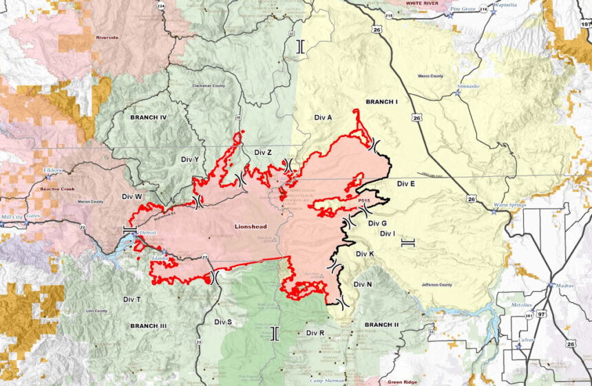
Lionshead Fire Update
Monday, September 21, 2020 – 10 a.m.
Firefighters Continue to Take Advantage of Cooler Weather
Current Situation: The weather continues to stabilize with moderate temperatures and slightly lower humidities. Patchy clouds and fog are expected over parts of the fire this morning. As light fuels dry out over the next couple of days, activity in fine fuels may increase. More smoke may be expected, particularly as green islands within the perimeter burn out.
Some Canadian crews and overhead arrived on the fire on Sunday. This international assistance comes at a time of unprecedented resource demands.
A Virtual Fire Information Public Meeting is being planned for Wednesday, September 23. More information will follow.
Firefighting Efforts by Division: (Refer to the map for division breakdown.)
Good progress was made Sunday on Division A, the northeastern portion of the fire. Crews worked directly on the fire’s edge towards Badger Butte, reassessing containment options and conducting a small burnout operation along an existing road system. Crews were able to build sections of line and plan for filling in gaps in the line moving forward. Green islands inside the fire perimeter in Division A will produce smoke as fuels are consumed.
The eastern fire edge in Divisions A and E is secure, but crews will continue to mop up and patrol for hotspots. Crews conducted direct line work to contain the fire spread to the north. Most of the east side of the fire on the Warm Springs Reservation is contained. Division E is in patrol and mop up status with chipping work beginning today along the road system.
The east side of the fire in Divisions G, I, K, and N has been quiet for several days and continues to be secure. Firefighters will continue to monitor and patrol this area.
On the southeast perimeter, working west from the Division N/R break (north of Jefferson Lake), the fireline has been secured west to the lava rock in Division R. No crews have been placed on the fire edge in this division or in the eastern portion of Division S due to safety concerns and low potential for fire spread. Fire managers are monitoring this area with aircraft.
In Division S, within the wilderness, the fire has not moved in several days and currently does not pose a concern. On the west side of Division S, a combination of hand and dozer line is being constructed using a historic burn scar as an anchor point and tying into Highway 22. Line construction continues west into Division T as terrain allows. Efforts moving towards Division W become more difficult as terrain becomes steeper.
In Division T, the areas of Idanha and New Idanha and private lands to the south of the fire are looking good. In many places the fire has checked itself as it burns up against road systems. Structure protection efforts continue. Utility companies are starting to repair infrastructure in the Detroit area. One focus today will be continued work on a large spot fire near Stahlman Point and the Cove Creek Campground.
On the northwest flank of the fire in Division W, fire managers are developing suppression plans. There are currently no crews assigned to the division due to higher priorities elsewhere.
Continuing east to Division Y, in the finger of fire to the north, firefighters focused on containing a spot fire and an area where the fire crossed Highway 46.
In Division Z, an indirect line is being prepped and improved. The 46 Road remains closed due to the large amount of heavy equipment required for this effort. This road will remain closed until snag hazards are cleared and the road is deemed safe for public travel.
Two contingency groups are building indirect fireline. These lines will only be used in the event that fire activity increases, and firefighters are not able to engage the fire directly. The south contingency group is working along County Road 12 to County Road 20, creating fuel breaks along the road. Expect heavy equipment traffic in this area. The north contingency group is working in close coordination with Riverside Fire managers to identify opportunities to connect existing roads that both fires could use in the event these indirect lines are needed.
Thanks to improved visibility, firefighters were able fly sections of the fire, putting in over 14 hours of flight time on Sunday. Heavy helicopters did water bucket work. Additional helispots were identified. Critically needed radio repeaters were installed Sunday.
Weather & Fuel Conditions: Mild conditions are expected to continue for the next couple of days with little change to temperatures, humidity, and winds. There will be an increasing chance of rain on Wednesday and Thursday.
Closures and Evacuations: Evacuation Notices remain in place for the Lionshead Fire. Level 3 “Go!” evacuation notices are still in place for the communities of Detroit, Idanha, and Breitenbush. There are no longer any evacuation notices for the Sidwalter/Miller flats area.
Roads and trails near the fire remain closed for public safety. This includes roads and trails on the Confederated Tribes of Warm Spring lands adjacent to the fire and a 40-mile section of the Pacific Crest Trail between Santiam Pass and Olallie Lake. Forest closures are in place for Deschutes, Mt. Hood and Willamette National Forests: Deschutes NF Alerts Willamette NF Alerts Mt. Hood NF Alerts.
Temporary Flight Restrictions: A Temporary Flight Restriction is in place over the Lionshead Fire and surrounding fires. Wildfires are a No Drone Zone. If you fly, we can’t. Whenever a drone is spotted near the fire all aircraft are grounded until we can be sure the drone is clear of the area. For more information, visit knowbeforeyoufly.org.
Reminder: Schools re-open on Tuesday, September 22, 2020. Traffic safety is a priority.
| Lionshead Fire Statistics: Size: 199,022 acres Containment: 13% Total Personnel: 1,122 Location: 14 miles west of Warm Springs Reported: 8/16/20, approximately 8:44 p.m. Cause: Lightning | For More Information: Information Office: 971-277-5075, 8 a.m. to 8 p.m. Media Inquiries: 541-904-0542 Email: 2020.lionshead@firenet.gov InciWeb: https://inciweb.nwcg.gov/incident/7049/ You Tube: http://www.youtube.com/channel/UCHSR6_yJRQkHyGjvvqX99gw Facebook: facebook.com/LionsheadFire |
Two Four Two Fire
September 21, 2020 11:00 a.m.
Oregon Department of Forestry IMT 2
Bill Hunt, Incident Commander
Email contact—twofourtwofire.information@gmail.com
Public Information Line: (541) 846-8174
Inciweb—https://inciweb.nwcg.gov/incident/7159/
Facebook—https://www.facebook.com/TwoFourTwoFire/
Size: 14,473 Acres
Containment: 77%
Start Date: Sept. 7, 2020
7:00 p.m.
Expected Containment Date: Sept. 25, 2020
Location: Northwest of Chiloquin, Oregon
Cause: Unknown
Est. Cost: $6.4 million
Personnel: 399
Resources: 8 hand crews
22 Engines
6 Dozers
11 Water Tenders
Aircraft: 3 Helicopters
Evacuations: None
Structures
Threatened: 0
Structures
Damaged: 33
Structures
Destroyed: 48
Closures: None
Fire Summary:
Today is the last day that the National Guard will be working a full shift
on the Two Four Two Fire. We thank them for their contributions and personal sacrifice in helping with our firefighting efforts and wish them a safe return home.
Crews will continue mop up and gridding for smoke in the fire area. Firefighters have almost completed mopping up 100 feet into the interior of the fire, around the perimeter. There is some remaining heat on the west side of Highway 62 that crews will focus on. The team is planning to transition to a Type 4 team made up of ODF and USFS resources on Wednesday, Sept. 23rd at 8a.m.
Safety always comes first. Snags are an extreme hazard to firefighters
and the public following any wildfire. Heather Berg, USFS Agency Administrator, stated in last night’s virtual community meeting that the U.S Forest Service land will remain closed to the public in the fire area. U.S Forest Service and the Oregon Department of Forestry will continue working in the fire area to rehabilitate fire line and evaluate post fire restoration work.
The virtual community meeting from last night can be viewed on the Two
Four Two Fire Facebook page. No account is required to view the video.
Firefighter and public safety is the priority during this incident, including
COVID mitigation. Personnel will be following Center for Disease Control guidelines to limit personal interactions both within camp and with the local community. The incident command post and fire camp are closed to the public and media.
BEACHIE CREEK FIRE UPDATE – September 21, 2020
Acres: 192,764 acres
Percent Containment: 38%
Start Date: August 16, 2020
Cause: Under Investigation
Origin Location: Opal Creek Wilderness: two miles south of Jawbone Flats, six miles north of Detroit, Oregon.
Fuels: Timber and logging slash Resources: 826
Flights: Temporary Flight Restriction
Virtual Community Meeting Beachie Creek Fire, Tuesday, September 22, 6 pm,
Beachie Creek Facebook Live: https://www.facebook.com/BeachieCreekFire2020
Incident Management Team advises residents and drivers of hazards
Be Alert for: Rockslides, Falling Trees, Hot Ash, and Emergency Equipment
Salem, Ore. – Additional hot shot crews and Canadian firefighters are directly attacking hot spots Monday on the Beachie Creek fire. These new resources are working the southern edge of the fire along State Route 22 between Stayton and Detroit. There is heat around Rock Creek, and crews are securing that area. The North Fork area remains closed and structural firefighter crews are there conducting additional protection and safety work.
The Incident Management Team and Marion County Sheriff are advising residents about potential hazards of hot ash, falling trees, hazardous debris, and possible rockslides. A tree may look alive and green; and yet, the fire may have burned the base, making it a falling hazard. On State Route 22, debris is constantly being removed which is why it remains closed. Insurance firms are getting in the area to assess damage, and utility companies are making repairs.
The Marion County Sheriff deputies are also escorting specific boat owners in the removal of boats from Detroit Lake due to low water levels; only those owners whose names are on the Sheriff’s list are allowed in the area.
Firefighters are working directly on the western edge connecting the pieces of containment line, and weather conditions will be favorable this Monday and Tuesday. Just to the east of Silver Falls State Park, adjacent to the fire line, heavy equipment will be used to strengthen the containment lines.
Over on the eastern edge of the fire, there is more intense heat in the Nasty Rock area, pushing towards Burnt Mountain; additional acreage will burn there on Monday. By Wednesday, a windy and wet weather pattern moves in that is forecast to produce up to an inch of rain. Wind gusts could reach 45 miles per hour; crews are preparing the areas for the weather.
Currently 1,118 structures are at Level 3 evacuations and another 4,574 are in level 2 evacuations. As more residents are allowed back into the area, it is imperative that everyone heeds road closures and safety messages. Anyone who enters the fire perimeter jeopardizes firefighting operations and puts lives at risk.
The Willamette National Forest, Bureau of Land Management, and State lands around the fire remain closed to the public. Go to InciWeb.gov for more information about closures in the area.
| Public Contact Information: https://www.facebook.com/BeachieCreekFire2020 Email: 2020.beachiecreek@firenet.gov Phone: 541-583-0526, 8 a.m. to 8 p.m. | Inciweb https://inciweb.nwcg.gov/incident/7001/ Smoke and Air Quality http://oregonsmoke.blogspot.com/p/air-quality-now.html https://wildlandfiresmoke.n |
Holiday Farm Fire Information
September 21, 2020
Oregon Department of Forestry IMT 3
Link Smith, Incident Commander
Holiday Farm Fire Information: (541) 357-9729 (7am—9pm)
Lane County Non-Emergency Call Center: 541-682-3977 (7am-9pm)
Linn County Non-Emergency Call Center: 541-812-2260
https://inciweb.nwcg.gov/incident/7170/ email: holidayfarmfireinfo@gmail.com
Estimated Size: 170,637 acres
Containment: 17%
Start Date/Time: 9/7/2020 8:20 p.m.
Expected
Containment Date: 10/29/2020
Location: Lane County
Cause: Unknown
Personnel: 985
Assigned Resources:
Hand Crews: 30
Engines: 43
Dozers: 28
Water Tenders: 28
Other Heavy
Equipment: 3
Assigned Aircraft: 6
Structure Task Forces: 0
Firefighter Injuries: 5
Structures
Threatened: 6,908
Structures Destroyed
Residences: 431
Non-Residential 24
Evacuations:
Ready Set Go
Level 1 (BE READY)
and Level 2 (BE SET)
are in effect.
Springfield, Ore. – An overnight infrared flight of the Holiday Farm Fire revealed the new fire size at 170,637 acres, down by about 2,400 acres due to better mapping. The fire is now 17 percent contained.
Firefighting personnel numbers are now at 985. Firefighting resources are
beginning to grow as crews complete assignments in Oregon and other states, take a couple of days of rest, and then get re-assigned to fires like Holiday Farm.
Crews working the fire represent 18 states and three provinces from Canada. Just over 100 Canadian firefighters from British Columbia, Ontario and Alberta arrived and received a briefing from ODF’s Type 1 team Sunday afternoon and headed to the fire line this morning.
The National Guard is also assisting the firefighting effort with six 20-person crews working to improve fire containment lines on the west side of the fire.
Firefighters are doing all they can to strengthen containment lines and begin mop-up operations in key areas ahead of another weather system moving in Wednesday that will bring elevated winds out of the southwest. Rain is also expected later in the day on Wednesday.
Hazards along Highway 126 still exist. The McKenzie Highway remains closed between Leaburg Dam Road (mp 23.9) and McKenzie River Drive (mp 46.3). For more information regarding road closures and delays, visit
https://www.oregon.gov/odot/Pages/Wildfire.aspx or
www.tripcheck.com.
Level 1 and 2 evacuation notifications remain in effect for several communities within and bordering the fire area. For more information on current evacuation levels, visit www.lanecounty.org/mckenziefire for Lane County and www.linnsheriff.org/fire_live_updates_sept_2020/ for Linn County.
Please continue to monitor cell phones, landlines, local media and official information sources for evacuation updates. Fire managers request that the public please avoid the area.
ODOT Monday afternoon update:
OR 126 McKenzie Highway update: The closure barrier has changed on the east end. The road is now closed between Leaburg Dam Road and Blue River Drive, milepost 23.9 to 39.8. Hazard tree removal continues throughout the closure area. Check TripCheck.com or call 5-1-1 for current closure boundaries.
Residents accessing reopened areas are asked to avoid barricaded locations for their own safety. Fire-damaged structures can be extremely hazardous and residents are encouraged to have professionals assess and deal with damaged areas once those areas open for return. Serious hazards can include unstable and falling debris, toxic substance exposure including asbestos and eye/lung/skin impact from ash and other irritants. See more at https://lanecounty.org/mckenziefire_resources.
BRATTAIN FIRE UPDATE
September 21, 2020 @ 9 AM
Yesterday:
Many more positive developments were made yesterday, especially with mop-up activity. We experienced only moderate fire behavior, with the same creeping and smoldering we have seen for several days, with smoke mostly coming from the interior in the northwest corner of the fire. The northwest corner has heavy down and dead fuel loading which continues to slowly burn. Crews have a good handle on the location of those hotter areas. We continued mop-up and patrolling lines in all divisions. Firing operations hastened burning of unburned fuels in the interior islands to reinforce fire control lines. Crews encountered mild, southwest terrain-driven winds and no red flag warnings. We are moving into more active repair/rehab operations, and a special suppression repair group was onsite beginning last evening scouting and looking at road and contingency lines. Incident operations are moving toward a more local incident management team by the end of the week.
Today:
Expect the same creeping and smoldering we saw yesterday, with smoke mostly coming from the interior in the northwest corner of the fire. Fuels along the line and interior pockets will continue to burn actively. Breezy conditions will continue Monday-Wednesday. We will continue mop-up and patrol lines in all divisions. Priority activities today include mop-up on the dozer line behind Withers Ranch and suppression activity repair/rehabilitation. A special landowner meeting was held today for landowners impacted by the Brattain Fire.
Evacuations:
The Lake County Sheriff’s Office has updated the following evacuation notices:
Level 2 (Set) – South of the Murphy Ranch on Clover Flat Road east to Valley Falls
Level 1 (Ready) –Highway 395 from Valley Falls east to Chandler State Park; Highway 31 from Summer Lake Store south to Red House Lane, all of Paisley to Valley Falls; Clover Flat Road from Hwy 31 (Beachler’s Corner) to Murphy Ranch
Forest Closure:
From Forest Road 29 southeast to Forest Road 3510 and the 28 Road east, all National Forest System lands and facilities are closed per Forest Closure Order 06-02-03-20-03. Forest Road 3315 is closed; the 28 Road is open.
Summary:
The Brattain fire started on September 7, 2020 and is currently burning on the Paisley Ranger District of the Fremont-Winema National Forest. The Eastern Area Incident Management Team is currently managing the fire but will soon transition out and a smaller, more localized team will take over incident operations. Firefighting crews continue to operate on a 24-hour schedule and are battling winds, extremely dry conditions and shortages of firefighting resources.
SIZE: 50,447 acres
CONTAINMENT: 52%
CAUSE: Human
PERSONNEL: 478
FIRE INFORMATION:541-947-6243 2020
email 2020.brattain@firenet.gov
INCIWEB: inciweb.nwcg.gov search “Brattain Fire”
Facebook: facebook.com, search: Fremont-Winema National Forest @R6FWNFSouth Central Oregon Fire Management Partnership @SCOFMPFIREINFO
