Crews make progress on Oregon’s major wildfires; no. of missing rises to 9
(Update: Four more missing persons, count at nine)
SALEM, Ore. (KTVZ) -- The death toll remains at nine from the recent devastating wildfires in several areas of Oregon, but the number of those missing rose on Monday, officials said.
While the Oregon Office of Emergency Management still reported a death toll of nine on Monday from the wildfires, the numbers of people reported missing rose by four, to nine.
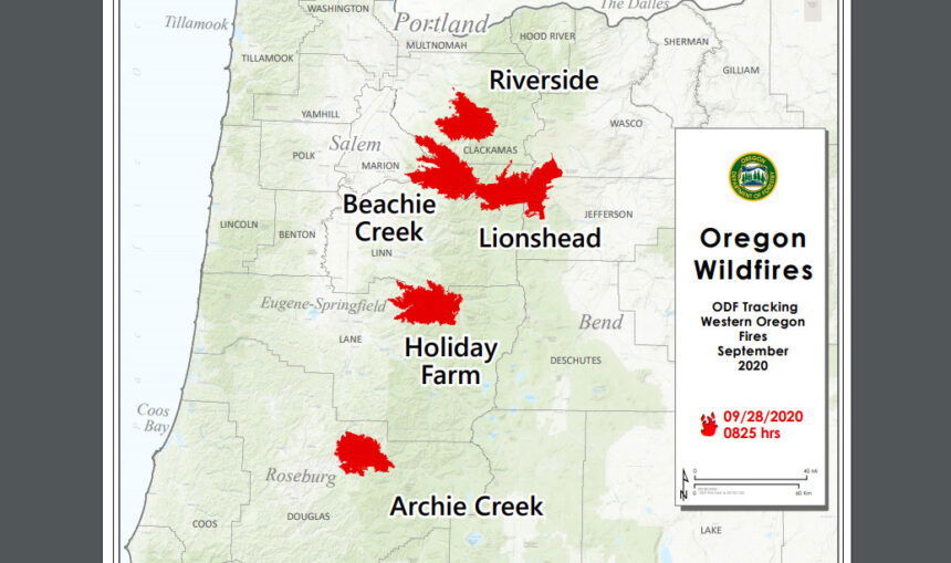
There were more gains in containment over the weekend on all six major fires in Oregon that the Oregon Department of Forestry is tracking, down from 17 originally, officials said Monday.
Fires are removed from the list when they are 100% lined and fire managers are confident in their progress toward containment. On that basis, the Thielsen Fire, which has not grown from 9,971 acres in days and is more than two-thirds contained, has been removed.
There have been more than 7,500 personnel assigned to these fires, not including many of the government employees, land owners, forestland operators, and members of the community who are contributing every day. There have been resources from 39 states and multiple Canadian provinces in this fight alongside Oregonians.
About 1 million acres have burned in Oregon since the start of this year, which is nearly double the 10-year average of approximately 557,811.
| Fire name | Acres burned (est.) | Containment | Location |
| Lionshead | 204,340 | 34% | 20 miles W of Warm Springs |
| Beachie Creek | 192,838 | 58% | 15 miles N of Detroit |
| Holiday Farm | 173,094 | 55% | 3 miles W of McKenzie Bridge |
| Riverside | 138,029 | 37% | 2 miles SE of Estacada |
| Archie Creek | 131,542 | 69% | 20 miles E of Glide |
| Slater | 44,239 in Oregon | 38% | 6 SE of Cave Junction (also in No. California) |
More information
- ODF wildfire blog and Significant Fire Potential Map
- Northwest Coordination Center – Regional Update and National Situation Report
- Inciweb (information on individual incidents
Holiday Farm Fire update
For Sept. 28
Springfield, Ore. – Firefighters on the Holiday Farm Fire welcomed another favorable day of weather Sunday. Calm winds and blue skies produced perfect working conditions that helped bump containment to 55 percent. The fire has not spread from its current footprint of 173,094 acres in seven days.
The area will continue to turn from warm to hot over the next few days with an east wind component that is expected to stir fire behavior inside the interior of the fire. Residents and passersby can expect to see small columns of smoke within the fire’s interior over the next few days. These “smokes” pose minimal threat to crossing containment lines or threatening homes. Fire personnel are encouraging the public to not report these smokes to emergency services as they overload the system and create unnecessary response.
Hazard tree and debris removal will continue along Highway 126, but local motor vehicle traffic will be allowed through with a pilot car along a 10-mile stretch between mileposts 28 and 38.
For more information regarding road closures and delays, visit https://www.oregon.gov/odot/Pages/Wildfire.aspx or www.tripcheck.com.
ODF Team 3 remains committed to the safety of the public and wildland fire personnel. All fire personnel are expected to follow recommendations from the Centers for Disease Control for preventing the spread of COVID-19. To date, zero cases of COVID-19 have been reported on the Holiday Farm Fire.
BEACHIE CREEK FIRE UPDATE – September 28, 2020
Acres: 192,843 acres Percent Containment: 58%
Start Date: August 16, 2020 Cause: Under Investigation
Origin Location: Opal Creek Wilderness: Fuels: Timber and logging slash
two miles south of Jawbone Flats, six Flights: Temporary Flight
miles north of Detroit, OregonRestriction on east side
Resources: 579
Prepare to see and smell smoke but the fire is not growing
East winds push smoke west Monday right to Silverton, Silverton hills,
Silver Falls State Park, and likely Lyons
Salem, Ore. –A strong warming and drying weather pattern moves over the Cascades Monday and shifts wind direction, pushing smoke right into the communities on the western flank of the Beachie Creek fire. With wind gusts up to 35 miles per hour, you will likely see and smell smoke, but the fire is not growing.
Within the fire’s footprint, tree stumps continue to smolder where the fire moved underground burning root systems. On Monday, ground fire may get oxygen, producing more smoke. The fuels are too wet to allow growth, but a few flames might be seen that will not go anywhere. This is typical fire behavior, and this smoldering will go on for weeks or months but is not likely to escape the fireline.
In the Abiqua Basin area, contractors are working with heavy equipment to remove downed trees and mitigate hazards so firefighters can get deeper into the forest to seek and destroy remaining heat. Suppression crews remain in the North Fork / Elkhorn area. Canadian crews continue to mitigate hazards along the southern perimeter.
In the Detroit to Cumley Creek area, Monday’s thermal belt will hold temperatures at night; then in the day, the strong winds shift directions potentially downing trees. Fire weakened trees continue to fall on area roads. The Oregon Department of Transportation has removed 19,200 trees off roads since the Beachie Creek fire started on August 16, 2020. Monday’s winds could result in more falling hazards; residents and motorists must be aware of their surroundings.
The Southwest Area Type 1 Incident Management Team remains confident with its direct and contingency containment lines. On Monday, another Type 1 team, the Pacific Northwest 3, shadows operations and assumes command on Tuesday. Teams typically rotate every 14 days.
The Bureau of Land Management, and State lands around the fire remain closed to the public. Parts of the Willamette National Forest are closed, and visitors are encouraged to check closures on the National Forest Website and be aware that there is still fire danger in the burn area. The burn area is off-limits to all visitors. Go to InciWeb.gov for more information about closures in the area.
Confederated Tribes of Warm Springs Lionshead Fire Update
Monday, Sept. 28
Brian Gales, Incident Commander Lonnie Click, Deputy IC
| Start date: Aug. 16, 2020 | Containment: 34% | facebook.com/LionsheadFire |
| Fire size: 204,340 acres | Public information: 971-277-5075 | https://inciweb.nwcg.gov/incident/7049/ |
REDMOND, Ore. – Fire crews are completing more containment line each day and looking for ways to attack the fire more directly where conditions allow. Pacific Northwest Team 13 under Incident Commander Brian Gales has assumed management of the fire.
The tribe has begun Burned Area Emergency Response (BAER) work, which will be used to guide restoration within the burn zone. Today, wildlife biologists will be conducting aerial assessments.
Structural protection crews have shifted to patrol and chipping operations in Detroit and Idanha, as well as gathering the miles of hose used during the suppression effort.
Today, wind speeds of 20-25 miles per hour are expected, with gusts of 30 to 35. This will increase fire activity, primarily consuming fuels in the interior, particularly in open areas. Crews are strategically positioned to address flareups and spot fires.
Fire managers are developing hazard tree removal plans for Hwy. 22 to ensure safe public access, and for the 46 corridor to provide crews safe entry for mopup. On the southwest corner of the fire, crews have removed hazard trees in the Stahlman Cabin area. The eastern boundary of the fire is now in patrol status, with crews focusing on line rehabilitation and chipping. Aviation was able to provide water support with a sky crane Sunday and will continue doing so today.
Fire managers are coordinating with their counterparts on the Riverside Fire to establish contingency lines to the north and along the power line corridor. Firefighters expect to complete more line along the southern boundary in the coming days and begin mop up work in those areas.
Weather & Fuel Conditions: Temperatures will rise into the low 80s Tuesday, with lighter winds changing from the east/southeast to a more southeastern alignment.
Closures and Evacuations: Evacuation levels around Detroit, Idanha, and the Elkhorn community along North Fork Road are at Level 2 – “Be Set.” Due to the remaining hazards in the cities of Detroit and Idanha, plus lack of basic services, non-residents should avoid travel to this area. Marion County Sheriff’s Office continues to coordinate with other law enforcement agencies to maintain an enhanced presence in the Detroit and Idanha areas as residents return to the area.
Residents of Linn County can find up to date information at www.LinnSheriff.org. There are no longer any evacuation notices for the Sidwalter/Miller Flats area in Jefferson County.
