Wildfires update: Quieter times on Central Oregon fire lines; closure order on 149-acre Potter Fire

(Update: Willamette National Forest fires update)
REDMOND, Ore. (KTVZ) -- While larger wildfires were battled elsewhere in Oregon, fire activity was relatively quiet Thursday around Central Oregon, allowing firefighters to make great progress increasing containment on existing blazes, officials said Friday.
Here's the Friday morning 8 a.m. Central Oregon Interagency Dispatch update, as well as Friday's updates on other fires:
Only one new fire was reported yesterday evening. Incident 558 is burning in grass and juniper on Prineville District BLM lands roughly 15 miles northwest of the town of Paulina. Air Attack estimated the fire was 2 acres in size last night. Three engines arrived on scene around 1:30 a.m. and stayed out on the fire overnight. Three engines and one Type 3 helicopter are assigned to the fire this morning. More information will be available once resources are able to assess the fire in daylight.
The 274-acre Fly Creek Fire is 95% contained. This fire is located near Balancing Rock along the Metolius arm of Lake Billy Chinook on the Deschutes National Forest. A Type 4 Incident Management Team will assume command of the fire this morning. The Jefferson County Sheriff’s Office lifted the Level 1 evacuation notice for the Three Rivers area and the Level 3 evacuation notice for the Perry South and Monty Campgrounds. The campgrounds will reopen for camping and recreation use today. This will be the final update on this fire unless there are significant changes.
Firefighters secured 100% containment yesterday on the 1.6-acre Juniper Creek Fire which is located roughly 10 air-miles south of the Fly Creek Fire.
Slightly cooler temperatures are expected again today with breezy conditions. Despite the slightly cooler temperatures, conditions will generally be warm and dry with low relative humidity across the area. High temperatures return again Sunday through Monday. The potential for hold-over fires still exists, especially as temperatures increase over the weekend.
As we move into a warm weekend, fire officials would like to remind the public to exercise caution as the potential for fire growth remains high. Check for fire restrictions before making plans to have a campfire. For more information on fire restrictions, visit: https://www.centraloregonfire.org/. If you do decide to enjoy a campfire in an approved fire ring at a designated campground, remember to drown, stir and feel before walking away. It should be cool enough to touch with your hand. Check your trailer chains to ensure they aren’t dragging; this can cause sparks. Avoid driving over or parking on dry vegetation. Fewer human-caused wildfires means that firefighters can focus on the natural-caused wildfires that can’t be prevented.
Central Oregon may experience smoke impacts from a few different active fires on neighboring forests and surrounding states. Smoke often settles into low-lying areas and river corridors overnight. The public is advised to ensure all windows and doors are securely closed in the evening and early morning hours to limit smoke exposure. For air quality information, visit: https://fire.airnow.gov/ or https://www.airnow.gov/. For more information on how to limit your smoke exposure, visit: https://www.centraloregonfire.org/wildfire-smoke-your-health/.
We will not be putting out an evening Central Oregon Interagency Dispatch update, since fire activity has decreased. We will only do a morning update moving forward unless there is significant fire activity to report. For current wildland fire information, the public can visit centraloregonfire.org or follow fire information on Twitter @CentralORfire.
Green Butte Fire - Friday 8 a.m. update:
The Green Butte Fire, located on the Bend-Fort Rock Ranger District on the Deschutes National Forest approximately 13 miles southeast of La Pine and approximately two miles northeast of Spring Butte, remains at 23 acres and is now 25% contained.
Yesterday, firefighters took advantage of the hose lay around the fire to mop-up to a depth of 40 feet around the perimeter. A local Type 3 Incident Management Team took command of the fire at 8:00 p.m. yesterday evening. Today firefighters will increase mop-up depth and continue to improve fireline where needed.
Resources assigned to the Green Butte Fire include the Prineville Hotshots, three hand crews, two engines, two water tenders, and one dozer.
For current wildland fire information, the public can visit centraloregonfire.org or follow fire information on Twitter @CentralORFire.
Willamette National Forest August 5, 5:30 pm FIRE UPDATE
Only one new fire was reported on the Willamette National Forest today. An abandoned campfire was found in the McKenzie River Ranger District and extinguished by an engine on patrol. The human-caused start is a reminder that fire restrictions are in place on the forest as of today.
- All campfires, charcoal or briquette fires, pellet fires, or any other fires will be prohibited, except in designated campgrounds.
- Portable cooking stoves, lanterns and heaters using liquefied or bottled fuel are still allowed if they can be switched on and off.
- Motorized vehicles may operate only on designated trails and roads, including within the Huckleberry Flats and Santiam Pass OHV areas.
Of the two small fires in the Three Sisters Wilderness area, one (#204) was declared out today and the smokejumpers staffing it began hiking out. The second fire, the Le Conte Fire, has been fully lined but jumpers will remain there to patrol until they are comfortable leaving.
Breezy conditions caused the Cedar Creek Fire to get more active with increased fire behavior. A Type 1 helicopter was employed much of today using water drops to hold the perimeter. Retardant was not used.
The Potter Fire remained about the same today at 149 acres with all divisions focusing on improving line and clearing roads. This fire is 0% contained.
There is a closure on the Willamette and Umpqua National Forests due to the Potter Fire. Click here for the closure order and the map: https://www.fs.usda.gov/detail/willamette/fire/?cid=fseprd552029
A multi-forest closure order is also now in place to protect firefighter and public safety during suppression efforts associated with the Windigo and Potter Fires. This closure includes portions of the Umpqua, Deschutes, Willamette and Fremont-Winema National Forests. For details go here: https://www.fs.usda.gov/detail/umpqua/notices/?cid=FSEPRD1047284&fbclid=IwAR0ODY2vuNOpbbEBcsxunRmqrLVDD5h8xltq5wj8r9fxjS-uqmhyhA5LUWo
Light winds out of the east are forecast for tomorrow morning which could mean some smoke in Oakridge but they are expected to switch to out of the northwest later in the day. A local Air Quality Advisor will be arriving tomorrow to assist the Willamette National Forest with smoke issues. For information about smoke, smoke forecasts and your health, the Oregon Smoke Blog is a good place to look: https://oregonsmoke.blogspot.com/.
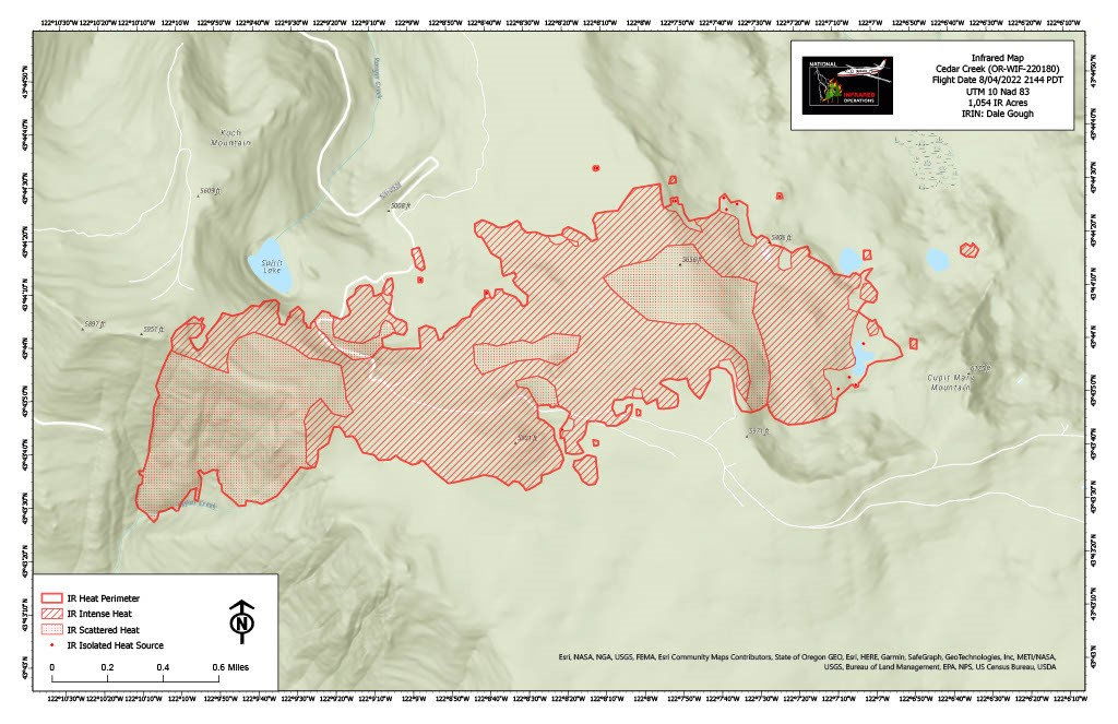
Earlier: The Cedar Creek Fire has moved directly east and last night’s infrared shows it to be 1,054 acres. Infrared flights are the most common way of measuring acreage change. A plane flies over the fire late at night, in this case at 9:44 pm, and uses special technology to measure heat on the ground. Areas with stripes indicate intense heat while areas with dots indicate scattered heat. Crews will also be wrapping the historic Waldo Lookout with a heat-reflecting material to try and keep it safe if the fire moves north.
Miller Road Fire Update
Friday, August 5, 2022 9:00 a.m.
NW IMT 8 Ed Hiatt, IC
OSFM Blue Team Scott Magers, IC
Miller Road Fire Information: (503) 383-9278 (8am - 6pm)
Email: osfm.fireinformation@gmail.com
Facebook: https://www.facebook.com/OfficialMillerRoadFire
Wasco County, OR – Cautious optimism was the tone on day two of the
Miller Road Fire. Light winds and moderate temperatures on Wednesday
allowed Oregon State Fire Marshal (OSFM) task forces and Oregon
Department of Forestry crews to start mop up operations.
The fire is still estimated at 11,186 acres and is now 25 percent
contained. Today’s weather will remain moderate, giving crews another
great opportunity ahead of next week’s forecasted triple-digit heat.
“The big push is to make as much progress as we can ahead of the
upcoming extreme weather,” said Scott Magers, OSFM Blue Team
Incident Commander. “Our crews have worked around the clock to get
us in a good position to protect lives and homes in Juniper Flat.”
Friday also brings additional resources into Wasco County. A Type-2
interagency incident management team, Northwest Interagency
Management Team (IMT) 8, joined OSFM and is in unified command.
The two teams will work together to provide support to the firefighters.
Crews will continue today to increase mop up operations, building
towards the goal of 100 feet from the fire’s perimeter.
“We’re thankful for the support of the Oregon Department of Forestry,”
Magers said. “Their collaboration and teamwork helped us follow
through on our mission of protecting life and property.”
Evacuation orders remain in place. The latest evacuation information can
be found by visiting www.facebook.com/WascoCountySheriff.
At mid-morning Friday, the Wasco County Sheriff’s Office reduced any evacuation alerts on the fire one level, or lifted entirely for Level 1 (Get Ready) properties.
The evacuation shelter at Dufur High School remains open at 802 NE 5th
Street. All roads throughout the area remained open to the public.
Malheur National Forest Fire Updates
Beech Creek Fire Update
JOHN DAY, PRAIRIE CITY, and HINES, OR – (Friday, August 5, 2022) Fire crews continue to work to contain the Beech Creek Fire located nine miles south of Long Creek along Highway 395. The fire is currently 183 acres and is 35% contained. The reduction in acreage is due to more accurate mapping. There are no evacuations in place.
On the northern portion of the fire, on the east side of Highway 395, firefighters continue to mop up, strengthen containment lines, and remove hazard trees along Highway 395. On the southern portion of the fire, numerous snags and fire weakened trees continue to pose a safety risk to fire crews. Equipment and falling teams have begun working along the fires edge to remove hazard trees. If hazards can be successfully mitigated, fire crews would be able to enter the area for direct suppression.
An additional containment line utilizing roads and completed dozer line has been established on the southern portion of the fire if direct attempts are unsuccessful. Strategic firing operations would be utilized to consume the unburned fuels between the indirect containment line and the fires edge. Utilizing this indirect containment line would reduce the safety risks to firefighters. Fire managers are closely monitoring weather and fire behavior to determine which containment lines can be successfully utilized.
Travelers will continue to see smoke in the area and are encouraged to check road conditions before traveling for up-to-date information on delays or closures. The public can monitor smoke and air quality across the state by visiting: http://oregonsmoke.blogspot.com.
Fire updates will continue to be aired on KJDY and will also be posted at Chester’s Market, the DinoMart in John Day, and the Chevron station in Mt. Vernon.
For more information and all the latest forest news on the Malheur National Forest, please visit our website at www.fs.usda.gov/malheur, follow U.S. Forest Service-Malheur National Forest on Facebook, and follow @MalheurNF on Twitter.
Willamette and Umpqua National Forests implement emergency closure order for Potter Fire
Springfield, Ore., Aug. 5, 2022— Officials have issued an emergency area closure for the Potter Fire on the Willamette and Umpqua National Forests. The Potter Fire was caused by lighting and has reached approximately 149 acres. It is located eight miles northeast of Toketee area and is 0% contained. The closure is implemented for the protection of public health and safety.
The Potter Fire was reported at 9 a.m., Sunday, July 31, 2022. It is near Potter Mountain on the Middle Fork Ranger District of the Willamette National Forest. The fire is being managed by Team 6.
For current updates on the fire visit https://inciweb.nwcg.gov/incident/8291/ or you can visit the “Windigo Fire and Potter Fire Information” Facebook page.
The following roads are closed to the public:
Roads: FS Roads 2133000, 2134000, 2134245, 2134246, 2134247; 2134248, 2134249, 2134250, 2134252, 2134257, 2134259, 2134262, 2134270, 2134350, 2136000, 2136160, 2136263, 2136265, 2136267, 2136268, 2136269, 2136272, 2136273, 2136275, 2136277, 2136283, 2136300, 2136301, 2136341, 2137000, 2137170, 2137264, 2137266, 2137270, 2137273, 2137274, 2137276, 2137363, 2143000, 2143219, 2143308, 2143309, 2143312, 2143351, 2144000, 2144332, 2144335, 2154000, 2154175, 2154236, 2154444, 3400000, 3810000, 5850000, 5851000, 5851109, 5851110, 5851121, & 5851319.
Campfires are still prohibited on the entire Willamette National Forest due to very high fire danger and ongoing active fires. For more information on fire restrictions or to find a detailed map and the full text of the closure order for the Potter Fire closure area, please visit: https://tinyurl.com/3semy5cu.
Follow us on Facebook and Twitter for updates @WillametteNF.
