Cedar Creek Fire tops 31,000 acres; crews tackle new fires near Brothers and Hole in the Ground
(Update: Adding info on small blazes near Brothers, Hole in the Ground)
BEND, Ore. (KTVZ) -- Days of hot, windy weather have sent the Cedar Creek Fire surging north and east, nearly doubling in size to over 31,000 acres, officials said Thursday after fire crews prepped evacuated Cultus Lake Lodge in aluminum wrap and widened the Level 3 evacuation ahead of yet another red flag warning.
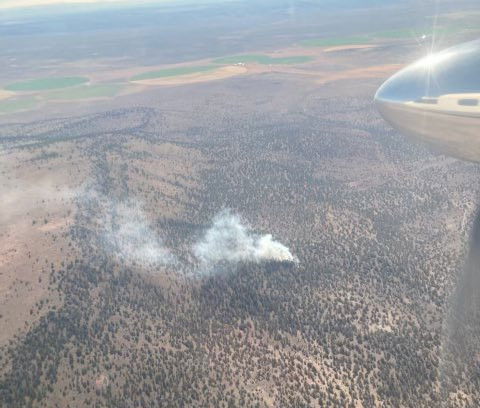
Meanwhile, firefighters responded Thursday afternoon to a small new wildfire on BLM land near Brothers, in eastern Deschutes County.
Incident 887 broke out six miles north of milepost 69 on Highway 20 in the Brothers-Hampton Wilderness Study area and was stopped before nightfall at 2.75 acres, Forest Service Public Affairs Officer Kassidy Kern said. Smokejumpers and rappellers continued to build fire line.
A Type 2 helicopter assisted suppression efforts on the ground and engine crews hiked into the research natural area, she said.
Another fire, Incident 883 (the McQueen Fire) burned about 21 acres four to five miles north of Hole in the Ground and was 80 percent contained by Thursday night, Kern added.
Here are the Thursday's updates on Cedar Creek and several other fires burning around the state.
First, here's the map of the Cedar Creek Fire and the update on its status:
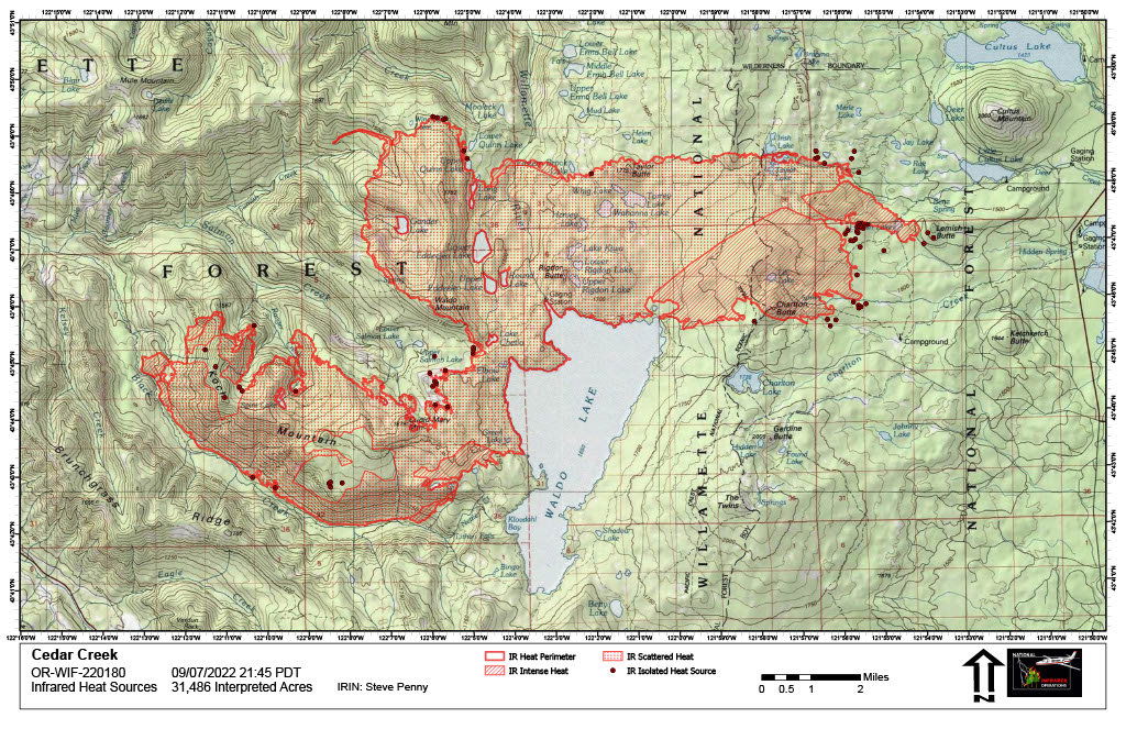
Cedar Creek Fire Daily Update
Sept. 8, 2022
Cedar Creek Fire Quick Facts
Size: 31,486 acres
Contained: 18%
Start Date: August 1, 2022
Location: 15 miles E of Oakridge, OR
Cause: Lightning
Total personnel: 849
Resources: 19 engines
15 crews
37 heavy equipment
7 helicopters
NEW EVACUATION LEVELS: Yesterday, theDeschutes County Sheriff’s Office has increased their evacuation levels for Cultus Lake and Crane Prairie Reservoir. Visit Deschutes and Lane County websites for up-to-date information.
RED FLAG WARNING: A Red Flag Warning will be in effect starting at midnight, Friday morning, due to low humidities and strong east winds. Winds speeds are expected to be 15-25 mph with gusts of up to 35 mph—Friday morning and afternoon. Winds are expected to increase throughout Friday evening with speeds 15-25 mph and gust up to 50 mph.
Virtual Community Meeting: Today Thursday, September 8th, 7:00PM, focused on Deschutes County and Central Oregon, virtually on the Cedar Creek Fire Facebook Page.
Current Situation: Yesterday, the fire continued to push northeast of Waldo Lake. It reached Lower Quinn Lake and Irish Lake in the north. In the east, it touched the base of Lemish Butte and crossed Charlton Butte. The fire is four miles from Crane Prairie Reservoir. Crews worked on point protection in the Cultus Lake Area securing aluminum structure wrap around the lodge and surrounding cabins, in addition to setting up sprinkler systems. Strategic burning operations were successfully completed on the northwestern edge of the fire along Forest Road (FR) 2417 and southwest edge along FR 2421 to secure lines at those points.
Today’s Activities: Today, firefighters will establish an anchor point on the northeastern edge of Waldo Lake and work towards Little Cultus Lake as a primary line of defense. Crews will continue point protection in the Cultus Lake area. On the western portion of the fire area, holding and improving lines is the primary objective. In anticipation of the Red Flag Warning, firefighters will be strategically placed around the fire overnight. Crews and equipment are prepared for initial attack on any new starts or spot fires and will relay current conditions throughout the evening. Alaska Team 1 that was prepositioned in Redmond is joining NW Team 6 to begin managing the eastern zone of the Cedar Creek Fire, effective tomorrow. Multiple teams managing a large fire allows on-the-ground resources to be supported closer to their firefighting activities.
Weather: High temperatures are predicted to reach 85°F in lower elevations and 77°F in higher elevations. Winds from the NW will reach speeds of 6-8 mph with gusts of up to 15 mph. Poor humidity levels overnight will allow for an extended burn window. A RED FLAG WARNING will be in effect starting at midnight, Friday morning.
Closures: The Deschutes National Forest and Willamette National Forest have implemented closures for the Cedar Creek Fire. Please visit Willamette National Forest and Deschutes National Forest for detailed closure orders and a joint map. A Temporary Flight Restriction (TFR) is in place. Pacific Crest Trail hikers should visit pcta.org for current information.
Restrictions: Fire restrictions are in place on the Willamette National Forest and Deschutes National Forest.
Smoke: Smoke Forecast Outlooks are available at https://outlooks.wildlandfiresmoke.net/outlook.
Fire Information: 8:00 AM – 8:00 PM | Phone: 541-201-2335 | Email: 2022.cedarcreek@firenet.gov
Online: https://inciweb.nwcg.gov/incident/8307/ | https://www.facebook.com/CedarCreekFire2022/ | https://www.facebook.com/willamettenf | https://twitter.com/willametteNF |
YouTube: https://www.tinyurl.com/cedarcreekfireyoutube
Evacuations: Deschutes County evacuation levels increased yesterday evening. Sign-up for emergency mobile alerts by going to oralert.gov Please check with Lane County Sheriff’s Office 541-682-4150 and Deschutes County Sheriff’s Office 541-693-6911 for updates and changes. Go to https://bit.ly/3D51kvC to view a map.
CEDAR CREEK FIRE EVACUATION INFORMATION FOR DESCHUTES COUNTY
September 7, 2022
Level 3 - GO NOW
· Areas east of the Lane County/Deschutes County Line, North of the Klamath County/Deschutes County line, northwest side of Wickiup Reservoir, the area surrounding Crane Prairie Reservoir and south of 6 Lakes Trail and Lava and Little Lava Lakes to include:
· Cultus Lake Lodge and Campground
· Little & Big Cove Boat-In Campground
· West Cultus Boat-In Campground
· Little Cultus
· Cultus Mountain
· Crane Prairie Reservoir
· Brown's Mountain
· Lemish Butte
· Ketchketch Butte
· Johnny Lake
Level 3 means leave immediately! Do NOT take time to gather things. GO NOW! There is immediate and imminent danger and you should evacuate immediately.
Level 2 - BE SET
· North of the line delineating Township 20S from Township 19S, east of the Lane County/Deschutes County line, south of 6 Lakes Trail, and west of Cascade Lakes Highway to include
· Lucky Butte
· Williamson Mountain
· Winopee, Snowshoe, Senoj, Big Finger, Upper Snowshoe, Long, Puppy, Leech, Goldeneye, and Lucky Lakes
· The northwest side of Davis Lake
· The area around South and North Twin Lakes west of Forest Road 4262 including Twin Lakes Lodge, Gull Point Campground, North Wickiup Campground and Sheep Bridge Campground
Level 2 means: You must prepare to leave at a moment’s notice, and this may be the only notice that you receive.
Level 1 - BE READY
· The area surrounding Lava and Little Lava Lakes
· Deschutes County 911 will be using wireless emergency alerts (WEA) to reach visitors in the evacuation areas that may not be signed up for Deschutes Alerts.
Level 1 means: This is the time for preparation and precautionary movement of persons with special needs, mobile property, pets and livestock. People should make the best possible decisions for their safety.
Van Meter Fire Update - Sept. 8
LAKEVIEW, Ore. — The Van Meter Fire is burning on Stukel Mountain, 13 miles southeast of Klamath Falls. The fire was reported on September 7, 2022, at 12:24 p.m. Current size estimate is 3,500 acres and no containment.
Fire personnel worked through the night on structure protection and fire suppression.
The local Type 3 Incident Management Team is managing the fire through tonight. A Type 1 Incident Management Team is enroute and will assume command on Thursday at 6 p.m.
A total of 260 structures are threatened and five structures have been confirmed lost to the blaze; one of which is a residence. All structures damaged are located on S. Poe Valley Road south of Beta Lane.
The following evacuations are in effect:
Level 3 (GO) – Crystal Springs Road east of Hill Road and South Poe Valley Road from Crystal Springs Road to Weber Road.
Level 2 (BE SET) – Harpold Road west to Hill Road North of Taylor Road, just north of the town Merrill.
For up-to-date evacuation orders call- 541-205-9730.
Weather: Significant fire potential remains elevated today due to the combination of high fire danger and hot, dry, and unstable weather. Holdover fires from yesterday’s lightning are likely to emerge.
Double Creek, Sturgill, Nebo, Goat Mountain Two Fires
September 8, 2022
Daily Update – 8:00 AM
Community Meeting Tonight: There will be a community meeting to discuss the Double Creek, Sturgill, Nebo, and Goat Mountain 2 Fires tonight at 6 p.m. The meeting will be held at the Joseph Event Center (102 E First, Joseph, OR) and will also be streamed live on Facebook.
Highlights: The passage of a cold front over the fire area yesterday brought gusty erratic winds which produced rapid fire growth on the Double Creek Fire. Before the strongest winds arrived in the evening, firefighters were able to complete firing operations along the Lower Imnaha Road to protect the community of Imnaha. Tactical firing and structure protection operations also took place on the south side of the Double Creek Fire. There was little fire growth on the fires in the Eagle Cap Wilderness.
Double Creek Fire: 100,977 acres | 0% contained | 553 personnel assigned
The lightning caused Double Creek Fire is a full suppression fire, and the protection of lives and property remain the primary objectives of this incident. As the cold front approached throughout the day, winds were gusty and erratic. As the front passed in the late afternoon high winds with gusts reported to 50 mph led to extreme fire behavior as the fire spread on Grizzly, Haas, Sleepy and Windy Ridges gaining over 30,000 acres. Firefighters conducted tactical firing operations from Imnaha north along the river corridor. Structure defense preparations took place for values in the Lightning and Horse Creek drainages and other structures north of the fire. Firefighters conducted firing operations and protected structures from Freezeout Road south to Balter Creek on the south side of the fire. Today firefighters, including Oregon State Fire Marshal (OSFM) task forces, will continue to secure the community of Imnaha and values north of the fire, keep the fire east of the Imnaha River and secure structures south of the fire, and assess structures along the Snake River.
Weather: With the passage of the cold front yesterday, slightly lower temperatures and lighter winds are expected today though it remains extremely dry. It will still be a day of elevated fire weather, but not the critical fire weather from the previous two days. Wind will be out of the northwest. In areas where the wind aligns with a northwest facing slope expect higher winds with gusts of 15-25 mph.
Smoke: Current air quality information for the local area is available on the Oregon Department of Environmental Quality – Air Quality Monitoring website and PurpleAir website.
Evacuation: A Level 3 “Go Now” is in effect for the Town of Imnaha north to Fence Creek (including lands east to Lightning Creek) and south to Grouse Creek. A Level 2 “Get Set” is in effect for Lostine River Road from Fir Road to Two Pan (including all campgrounds and trailheads), Upper Imnaha from Grouse Creek to Pallette Ranch, and areas around Dug Bar Road north of Fence Creek. A Level 1 “Be Ready” is in effect for Lostine River Road from Highway 82 to Fir Road and for Upper Imnaha Road from Pallette Ranch to Wallowa Mountain Road (FSR 39).
Closures: The Wallowa Whitman National Forest issued Temporary Area Closures for the Double Creek Fire, Nebo Fire, and Sturgill Fire (includes Goat Mountain 2 Fire) on Monday. Closure Orders and Maps are available on the Wallowa Whitman National Forest Fire Incident Updates page. The Wallowa County Sheriff’s Office has closed several roads associated with evacuations orders. Lostine River Road from Moffitt’s south is closed. Lower Imnaha and Dug Bar Roads are closed. The Upper Imnaha Road and Hat Point Road are closed. Wallowa Mountain Loop Road (FSR 39) is closed from Target Springs Junction to Ollokot Campground including the Canal Road (FSR 3920), and Lick Creek Rd (FSR 3925).
Airspace: Airspace restrictions have been issued for the Double Creek, Nebo, Sturgill, and Goat Mountain 2 Fires. Temporary Flight Restrictions were updated for the Double Creek Fire (TFR 2/3198) and the Sturgill Fire (TFR 2/3194) to provide a safe environment for firefighting aircraft operations over the fires. Notice to Air Missions (NOTAM) 08/234 and NOTAM 08/235 were issued to provide safe airspace for the Nebo and Goat Mountain 2 Fires. Flight restrictions also apply to drones. Drones flying in areas of wildfire activity will cause firefighting aircraft to be grounded.
Restrictions: Forest Order #06-16-00-22-04 covers Phase B Fire Restrictions for all National Forest System Lands within the Wallowa-Whitman National Forest, except for the area within a ¼ mile of the Snake River between Hells Canyon Dam, River Mile 247.5, downstream to the Oregon-Washington border at Snake River Mile 176.0, which is regulated by Forest Order #06-16-04-22-01.
Fire Information
Office Hours: 8:00 AM – 8:00 PM
Phone: 541-216-4579
Email: 2022.doublecreek@firenet.gov
- InciWeb: https://inciweb.nwcg.gov/incident/8366/
- Facebook: www.facebook.com/doublecreekfire2022
- YouTube: https://tinyurl.com/Double-Creek-Fire
Crockets Knob Fire Update
NORTHWEST INCIDENT MANAGEMENT TEAM 12
Incident Commanders: Jeff Dimke and Bobby Shindelar
September 08, 2022
Weather: Temperatures are expected to be cooler today, and winds will be calmer. Temperatures will be in the low-80s this afternoon with wind gusts up to 20 mph. Conditions will still be dry with relative humidity in the teens.
Operations: Yesterday the fire perimeter was tested by high winds, and firefighters kept the fire within established containment lines. The fire received some rainfall yesterday afternoon, which helped with mop up efforts. Spots west of the FSR 45 were completely mopped up and will continue to be monitored to ensure they remain secure. Mop up along the FSR 45 and FSR 537 continued, and improvements along the contingency line north of FSR 45 and FSR 537 were nearly completed. Today, heavy equipment should complete the contingency line up to the Sharp Ridge / Indian Rock Trailhead. On the northeastern and eastern flanks, containment lines are in place around the burned pockets of subalpine fir, and today crews will continue mopping up any remnant heat they find. Yesterday crews monitored and patrolled the southern edge of the fire, which will continue today. Crews will be removing excess hoses and equipment from secured containment lines on the western, southern and eastern edges of the fire. All containment lines will continue to be monitored and patrolled. Crews received minimal support from helicopters yesterday due to high winds and thunderstorms. With favorable weather, helicopters are expected to resume support of firefighting efforts along the northeastern flank.
Closures and Evacuations: Grant County has issued a Level One evacuation advisory in the area of the fire. Level One means be ready and aware of fire conditions. You can view a map of the evacuation zone on the Grant County Emergency Management Facebook page. A closure is in effect on the Malheur and Umatilla National Forests today. For complete closure information, please go to: https://www.fs.usda.gov/detail/malheur/notices/...
Smoke may be visible to nearby communities and Forest visitors. Smoke and air quality impacts within the state can be monitored by visiting: http://oregonsmoke.blogspot.com
Quick Facts:
SIZE: 4,326 Acres
CONTAINMENT: 35%
CAUSE: Lightning
PERSONNEL: 640
LOCATION: 19 miles north of Prairie City
FIRE INFORMATION: 541-625-0892
2022.crocketsknob@firenet.gov
FACEBOOK:https://www.facebook.com/CrocketsKnobFire
INCIWEB:https://inciweb.nwcg.gov/incident/8355/
TEMPORARY FLIGHT RESTRICTION
There is a Temporary Flight Restriction over the Crockets Knob Fire area. Wildfires are a No Drone Zone - if you fly, we can’t.
Fire size: 21,227 acres
Containment: 44%
Structures lost: 2 homes, 6 others
Resources assigned: 1,377
InciWeb: https://inciweb.nwcg.gov/incident/8348/
Containment increases to 44% on Rum Creek Fire
MERLIN, Ore. – Josephine County Sheriff’s Office has reduced or eliminated the evacuation notices for some of the areas near the Rum Creek Fire. Their evacuations are based on the system of Level 1 means GET READY, Level 2 means GET SET to leave at any moment, and Level 3 means GO NOW. Areas to the east of the fire, including the communities of Merlin, Hugo, Three Pines, Leland, and Wolf Creek, are no longer under the Level 1 notification. The Level 2 to the east of Hog Creek is reduced to a Level 1.
The Level 3 in and around the fire itself and the Level 2 south of the fire have not changed. Areas north of the fire remain under a Level 1 notice. For more detailed information, use the interactive map showing evacuation levels according to address at //JosephineCounty.gov/FireMap. For the most current evacuation information and resources, go to Josephine County Incident Information (rvem.org).
The reduction in evacuations is possible because of progress fire personnel have made on containing the Rum Creek Fire. On the west side, the fire is considered contained from west of Mount Peavine to Galice Road north of the Galice Resort. To the northwest, fire has consumed ground fuels on most of the previously unburned interior islands. This reduces the chance of fire flaring up and escaping past the fire lines to the north or west.
On the east side, nearly all of the fire’s edge is considered contained and has stayed within its footprint. Firefighters are monitoring fire lines and have mopped up inside all lines at least 75 feet. Firefighters will patrol and monitor the fire and continue to mop up residual heat near fire edges. No further spread is expected along these contained edges despite hot, dry, windy weather.
Weather continues to be a challenge for the Rum Creek Fire. The National Weather Service has issued a combination of Red Flag Warnings and Heat Advisories through Saturday. High temperatures, low relative humidity, gusty winds, and an unstable atmosphere are expected, raising the potential for new fires to develop and existing fires to spread. Winds from the east and northeast are predicted. Personnel on the Rum Creek Fire will be monitoring the weather and fire closely, ready to take action if the fire attempts to escape the containment lines.
The public is reminded to be careful with fire. Rum Creek Fire was ignited by lightning, but historically, most wildfires are human-caused. Check local fire restrictions before starting any fire or barbecue grill. Make sure all fires are completely extinguished and cold to the touch.
Evacuations: Evacuation orders and notifications have been revised. An interactive map showing evacuation levels according to address can be found at //JosephineCounty.gov/FireMap. For the most current evacuation information and resources, go to Josephine County Incident Information (rvem.org).
Road control: Josephine County Sheriff’s Office has established traffic access points around the fire zone. Road blocks are located at Galice Road near Crow Road; Galice Store; Bear Camp Road at Peavine (top intersection); Lower Grave Creek Road at Angora Creek (Grays Ranch); Quartz Creek Road about 3 miles up (end of County maintenance); Dutch Henry Road near Kelsey Creek (42 44'56.2/123 40'35.4); and Hog Creek at Galice Road. The National Guard is staffing the roadblocks. Only residents (must show proof of residency) and permitted users will be allowed through.
River status: The Wild section of the Rogue River below Grave Creek will remain open unless fire conditions warrant closure. River status is determined on a day-to-day basis. Please call 541-471-6535 for more information regarding Rogue River permits. No new boating permits will be issued at this time.
