Fire on Deschutes River SW of Maupin tops 1,000 acres, 50% contained; evacuation alert lowered, river, campgrounds reopen
(Update: Fire 50% contained; river, campgrounds reopen Tuesday)
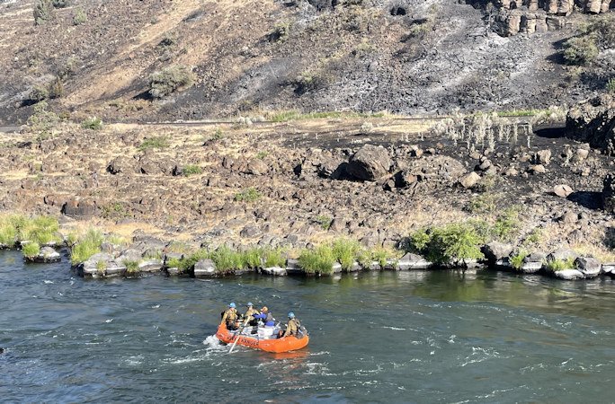
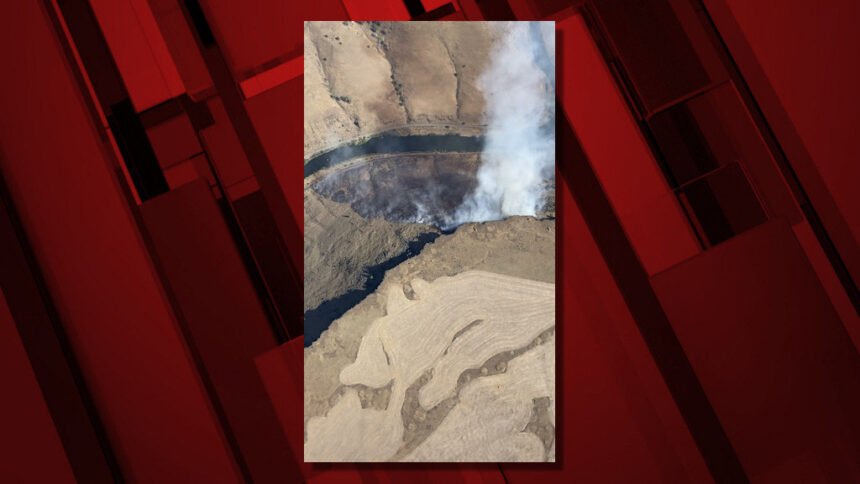
MAUPIN, Ore. (KTVZ) – The Long Bend Fire, which broke out late Saturday afternoon on the west side of the Deschutes River southwest of Maupin, grew to more than 1,000 acres, but crews - some transported by raft - brought it to 50% containment Monday, officials said.
"Crews made great progress" Monday, they said, and as a result, river access south of Maupin reopened Tuesday. Still, they advised, "Boaters should use caution, avoid pulling over on the 'fire side' of the river and follow directions of firefighters and river staff."
Harpham Flat and Wapinitia campgrounds, which were evacuated Saturday, also reopened Tuesday.
The progress prompted the Wasco County Sheriff's Office to return its pre-evacuation alert to the lowest, Level 1 'Get Ready' after raising it to the second of three levels, 'Get Set.'
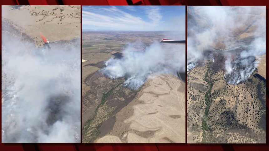
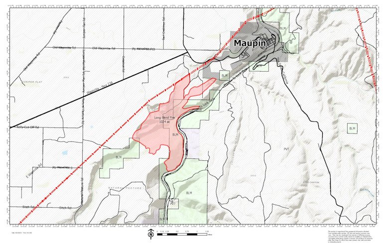
The Long Bend Fire (Incident #277) , burning about two miles southwest of Maupin, was estimated Monday at 1,024 acres, burning on Bureau of Land Management and private lands. The cause of the fire is still under investigation.
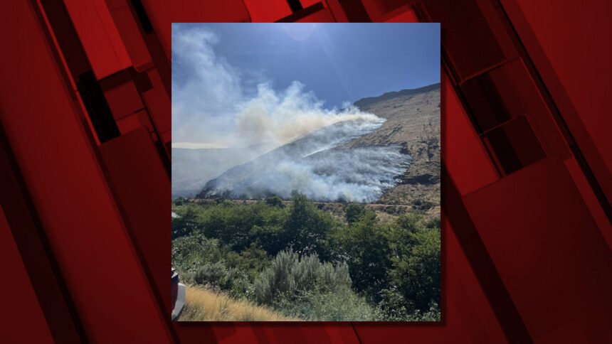
Most of the fire’s growth Sunday occurred in the Wapinitia Canyon area. Firefighters engaged on the western edge of the fire in places that were safe to access, while bulldozers conducted operations in the flat terrain above the canyon.
The southern and eastern portions of the fire remained quiet, officials said. Engines continue to patrol the eastern line to ensure that spot fires do not occur on the east side of the Deschutes River.
A Central Oregon Type 3 Incident Management Team took command of the Long Bend Fire at 3:30 p.m. Sunday, officials said on the Central Oregon Fire X (Twitter) feed. Fire officials had said Sunday evening the fire was estimated at 2,000 acres but later reduced it due to more accurate mapping.
Resources assigned to the incident Monday included a Type crew, four Type 2 initial attack crews, seven engines, three water tenders, a bulldozer, two Type 2 helicopters, a Type 3 helicopter and 25 overhead personnel.
Firefighters were looking Monday for opportunities to engage the fire directly along Wapinitia Creek. Crews also focused on patrolling and extinguishing sources of heat along the fire perimeter to secure control lines. Aircraft will assist ground resources as needed by dropping water to help cool hot spots.
"The fire is moving toward rimrock in some places, where it will act as a natural holding feature," the Sunday evening update stated; officials also gave the first containment figure so far, at 5%.
The National Weather Service issued a red flag warning for critical fire weather conditions for much of Central and NE Oregon and Washington from 1-8 p.m. Sunday.
Overnight, due to increased fire activity, the sheriff’s office issued a Level 1 “Be Ready” notice for all residences south of milepost 24 along Highway 216 to Blue Rock Road in Maupin.
Evacuations remain in place for the Harpham Flat and Wapinitia campground. Boaters in the area were asked to use caution, as helicopters may be dipping water out of the river.
Fire activity on the Long Bend Fire decreased early Sunday morning. Officials said the fire remained on the west side of the Deschutes River and was moving to the north and west, following the river drainage. The south end of the fire continued to be quiet, they said, with some slow spread to the southwest.
Rappellers were monitoring the Wapinitia Canyon area. The Juniper Flat Rural Fire Protection District was engaged in the northwest corner. An engine was patrolling the east side of the Deschutes River for any potential spot fires.
Resources engaged on the Long Bend Fire included eight engines, three water tenders, four rappellers and miscellaneous overhead personnel.
A 20-person hotshot crew was to arrive Sunday morning. A Type 3 incident commander took command of the fire overnight. Additional Type 3 Incident Management Team resources arrive Sunday.
Firefighters on the ground were supported by one Type 1 helicopter, one Type 2 helicopter and air attack.
The cause of the fire remained under investigation.
Central Oregon Fire Management Service firefighters responded to the blaze around 4:15 p.m. Saturday. It had grown to more than 100 acres by nightfall.
For current wildfire information, the public can visit centraloregonfire.org or follow fire information on X (Twitter) @CentralORFire.
The National Weather Service in Pendleton issued an expanded red flag waring that included much of Central Oregon through Sunday evening, warning that wind and low relative humidity could lead to “rapid fire spread and extreme fire behavior for new and existing fires.”
The warning began at 1 p.m. and continued until 8 p.m. for the mountains of Central Oregon and Lower Columbia Basin, as well as other areas to the north.
A red flag warning means critical fire weather conditions are or will occur.
Meanwhile, in southwest Oregon, the Upper Applegate Fire first spotted late Thursday afternoon south of Ruch has burned over 750 acres but was fully lined by Sunday evening, with more than 160 personnel assigned, the Oregon Department of Forestry reported. The Jackson County Sheriff's Office had issued Level 2 "Be Set" evacuation notices.
