Week-old Darlene Fire 100% contained; local team takes over; firefighters to mop up, patrol through the weekend
(Update: Tuesday morning info)
LA PINE, Ore. (KTVZ) -- A week after the fast-growing Darlene 3 Fire forced hundreds of La Pine-area residents to evacuate their homes, the blaze held by crews at just under 4,000 acres reached official full containment Tuesday as all Level 3 GO NOW evacuation levels were dropped.
A local Type 4 incident commander took over the fire Tuesday morning, officials said.
"Firefighters will remain on the fire, continuing to mop up hot spots and patrol through the weekend," they added.
Here's the Monday evening evacuation levels update from the Deschutes County Sheriff's Office:
UPDATE July 1, 2024 5:00 PM
After consultation with fire managers, the Deschutes County Sheriff's Office is lowering some evacuation levels effective 6 PM on July 1, 2024. These levels may change again as conditions change. Residents should remain vigilant and stay informed about changing conditions.
Current evacuation notices:
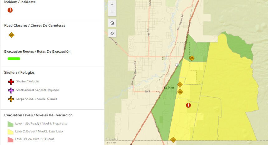
Level 2: Be Set - All areas immediately surrounding the Darlene 3 Fire including areas east of the BNSF railroad tracks, north of the Deschutes/Klamath County line, and public lands managed by the Bureau of Land Management and United States Forest Service.
Level 1: Be Ready - Newberry Estates subdivision off of Rosland Road and the commercial areas east of Hwy 97 near Wickiup Junction including areas off of Drafter Rd and Rosland Rd. Additionally all areas bound east of Hwy 97, north of Hwy 31 and west of the BNSF railroad tracks.
All other areas under various evacuation notices have remained unchanged.
Updated maps and information can be found at www.deschutes.org/emergency.
Numerous road closures remain in effect around the fire. The public is asked to respect these road closures as well as closures put in place by the Deschutes National Forest and Prineville District of the Bureau of Land Management. These closures are in place to protect the public and firefighters working in the area.
--
"The weather has contributed to the firefighters success and their hard work," Deputy Incident Commander Ted Adams said Sunday. "Their hard work is paying off, so that we can downsize this organization, reduce the impact and the presence of the firefighters."
A sign of progress was the reopening at noon Sunday of the McKay Crossing and Ogden Group campgrounds and Six Mile Sno-Park.
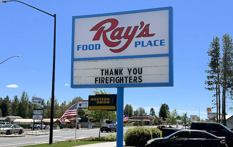
Another sign of progress: At the Red Cross shelter set up the day of the fire at La Pine High School came word Sunday that the shelter closed at 10 a.m. Monday. Those needing assistance were advised to call 1-800-RED-CROSS.
Here's Monday's report from fire officials:
Darlene 3 Fire | July 1, 2024
Central Oregon – The Darlene 3 Fire is now at 75% containment and remains 3,889 acres. Firefighters continue mopping up and looking for hot spots within the first 100 feet of the fire perimeter. Standing, unstable burned trees and stump holes with hot ash are within the fire area, firefighters are remaining cautious and taking care of these hazards as they can safely do so. Personnel are working to rehabilitate fire suppression activities within the interior portion of the fire and are back-hauling supplies that are no longer needed. Resources working the fire have been identified to help with initial attack, should there be any new starts in the area.
Tuesday morning, a local Type 4 incident commander will assume command of the Darlene 3 Fire. The COFMS Type 3 team will work closely with the incoming incident commander today to ensure there is a seamless transition of the fire. Engines, hand crews, water tenders, falling teams and heavy equipment will continue to work under the incoming Type 4 incident commander securing and rehabilitating the fire area. This will be the last daily update for the Darlene 3 Fire.
A warming trend begins today in Central Oregon, with temperatures by the end of the week expected to be near 100 degrees. With the Fourth of July holiday approaching, visitors and community members need to remember it only takes one spark to cause the next accidental wildfire. Public use fire restrictions went into effect today across Central Oregon. Please be sure to recreate responsibly and check fire restrictions for private and public lands.
Central Oregon District enters high fire danger July 1 | ODF Central Oregon District News
For the most up-to-date official evacuation information please visit Deschutes County evacuation information: www.deschutes.org/emergency.
Air quality information can be found at aqi.oregon.gov or by downloading the OregonAir app.
The public is urged to respect the current FS and BLM closure areas for the safety of themselves and our firefighters. Closure areas are being evaluated daily, and as fire activity allows the areas will be changed as appropriate. The Prairie Campground and the Rosland OHV area and associated trails will remain closed temporarily. McKay Crossing Campground, Ogden Group Campground and 6 Mile Sno Park reopened at noon on Sunday, June 30.
An Area Emergency Closure is in effect on the Deschutes National Forest, the notice and closure map are available here: https://www.fs.usda.gov/Internet/FSE_DOCUMENTS/fseprd1183408.pdf. Paulina Lake Road and Forest Service Road 22 east of the closure boundary are still open for public use.
The Prineville District Bureau of Land Management’s Emergency Public Land Closure also remains in effect. This notice is available online at https://www.blm.gov/programs/public-safety-and-fire/fire-and-aviation/regional-info/oregon-washington/fire-restrictions.
For continued updates on this fire and future wildfires in Central Oregon, visit centraloregonfire.org or follow fire information on X (Twitter) @CentralORFire. The Central Oregon Fire Info phone line is also available for community and media at: 541.316.7711.
--
Sunday's daily report from the National Interagency Fire Center says 304 firefighters and support personnel are still working in various capacities on the fire, such as mopping up hot spots and shoring up lines, although 131 headed home Saturday. The cost of the firefighting effort to date remains at $3.1 million.
"This fire grew very quickly," Stacy Long, a U.S. Forest Service wildfire prevention, mitigation and education specialist, said Saturday. "It was all because the temperatures were high that day. The wind was very strong out of the west that day."
The start of the Darlene 3 Fire brought frightening skies filled with billowing smoke, while firefighters on the ground took on the flames and planes and helicopters flew over to dump retardant and water on the fire.
La Pine resident Donald Lloyd Allen Cantrell recalled, "I grabbed my little girl here (his dog), Trinket, and she's my life. I was so turned around, I just grabbed a few things, and I was gone."
The fire caused residents to seek shelter at La Pine High School, where the American Red Cross is still staffing the evacuation shelter.
Disaster Program Manager Graham Bellairs said Saturday, "When you're displaced from your home, it is an extremely difficult time. And it's not necessarily high living, but it is shelter and food, and that's what counts."
Saturday was the the last day for the Oregon State Fire Marshal's Red Team on the incident, as they demobilized and headed home, with Central Oregon's Type 3 Incident Management Team taking over.
The number of homes at Level 2, meaning to "Be Set" to evacuate at a moment's notice, were more than 1,000. More than 40 were still at Level 3, which is "GO NOW."
Another La Pine resident, Chantel Helwig, said, "It was pretty mellow, considering how scary it was. And it was kind of frustrating, too, because as soon as the evacuations (levels) would drop lower, they would shoot back up."
The cause of the fire, which started on BLM land and is deemed human-caused, is still under investigation. As residents return to their homes, fire managers would like to remind everyone to maintain defensible space around your home.

