Containment on 64,000-acre Crazy Creek Fire inches upward to 6% amid burning operations, more hot, dry weather
(Update: Sunday fire update; Paulina under Level 2 BE SET evacuation notice)
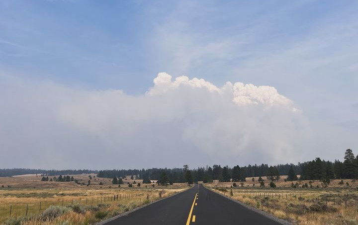
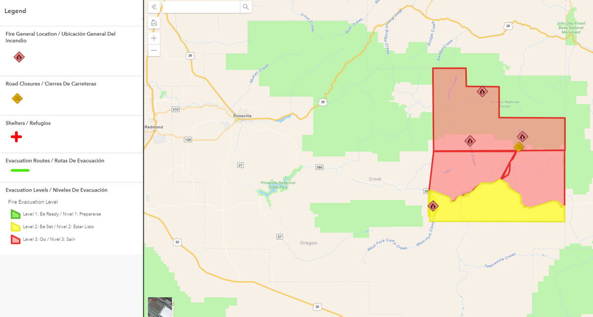
PAULINA, Ore. (KTVZ) --The 2-week-old Crazy Creek Fire in Crook and Wheeler counties has grown to more than 64,000 acres, and on Sunday prompted a Level 2 BE SET pre-evacuation alert to the town of Paulina and nearby areas.
The Crook County Sheriff's Office said in a 1 p.m. Facebook posting: "CCSO Command in conjunction with SWAIMT (SW Area Incident Management Team) 5 has issued a LEVEL 2 evacuation for Paulina proper/southside of Highway 380 from Camp Creek east to the county line."
Here's fire officials' Monday map and update:
Containment measures continue on Crazy Creek Fire; 498/Kitty Creek Fire at full containment
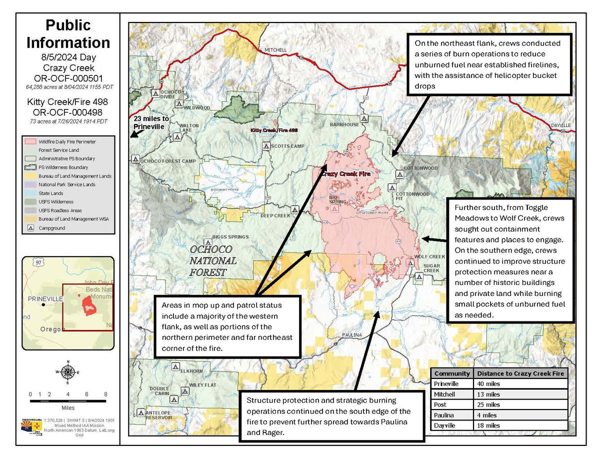
Daily Update August 5, 2024
Fire Information Phone:541-208-1768 (8am-8pm)
Media Information Phone:541-208-1770 (8am-8pm)
Email: 2024.crazycreek@firenet.gov
Acres: Crazy Creek – 64,288; 498/Kitty Creek – 73
Acreage changes may occur due to overnight operations and infrared mapping.
Location: Crazy Creek: 5 miles north of Paulina, OR Start Date: July 22, 2024
498/Kitty Creek: 7 miles south of Mitchell, OR Personnel: 582
Containment: Crazy Creek 6%; 498/Kitty Creek 100% Fuels: Timber and short grass
Resources: 12 crews | 1 helicopter | 31 engines | 11 bulldozers | 13 water tenders | 3 masticators | 17 skid steers
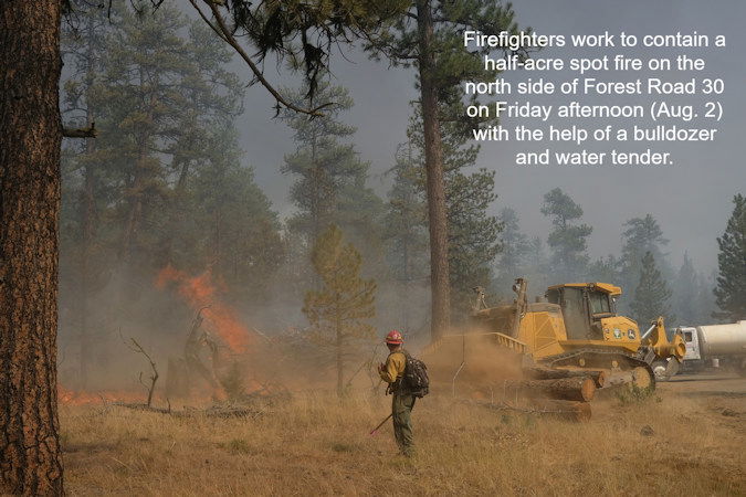
Highlights: Firefighters continued to work around the clock conducting firing operations on the eastern perimeter of the Crazy Creek Fire on August 4, in order to reduce the amount of unburned fuel between the main fire edge and Forest Road 30. Structure protection and strategic burning operations continued on the south edge of the fire to prevent further spread towards Paulina and Rager.
Fire Activity: After a relatively quiet day across the fire on Saturday, fire activity was elevated again on Sunday, with more critically hot and dry weather slated for the next three days. Given the forecast, a priority across the fire on Sunday was improving lines to withstand potentially extreme burning conditions.
On the northeast flank, crews conducted a series of burn operations to reduce unburned fuel near established firelines, with the assistance of helicopter bucket drops. Further south, from Toggle Meadows to Wolf Creek, crews sought out containment features and places to engage. On the southern edge, crews continued to improve structure protection measures near a number of historic buildings and private land while burning small pockets of unburned fuel as needed. Crews across the fire perimeter will continue to mop up and patrol where fire behavior has been less active. Areas in mop up and patrol status include a majority of the western flank, as well as portions of the northern perimeter and far northeast corner of the fire.
Evacuations: Mandatory evacuation orders remain in effect for areas in Crook and Wheeler counties for areas in or near the fire. Level 3 evacuations have extended from the Forest Boundary to Highway 380. Level 2 evacuations have extended south of Highway 380.
Weather: The threat of thunderstorms that was present over the fire area all weekend has subsided, but critically warm and dry conditions persist with low humidity, temperatures in the mid to upper 90s and moderate winds.
Importance of Fire Prevention: All public lands in Central Oregon, to include the Ochoco National Forest are in Stage 2 Public Use (Fire) Restrictions. All open flames, including woodstoves and charcoal briquette fires are prohibited. In times of high fire danger, it is crucial for everyone to follow fire prevention measures to avoid additional strain on overburdened resources. The public's cooperation in adhering to fire bans and restrictions is vital to prevent new fires from starting and to help our firefighters focus on containing the existing fires. Learn more at https://www.fs.usda.gov/alerts/ochoco/alerts-notices/?aid=89068.
Smoke: Smoke from multiple fires in Central Oregon are impacting the region. Additional details are available via https://outlooks.wildlandfiresmoke.net/outlook/079f0f73.
Fire Restrictions and Closures: The Ochoco National Forest has implemented a forest closure for the Paulina Ranger District. More information can be found at fs.usda.gov/alerts/ochoco/alerts-notices/?aid=89203. Bureau of Land Management has issued a temporary closure for public lands in Crook and Grant Counties. More information is available at https://www.blm.gov/sites/default/files/docs/2024-08/orwa-fpo-pri-paulina-080224.pdf.
More Information:
InciWeb: https://inciweb.wildfire.gov/incident-information/orocf-crazy-creek
Facebook: https://www.facebook.com/SWIMT5
Central Oregon Wildfire Information: https://centraloregonfire.org/
Crook County Emergency Information Map: https://arcg.is/1ij0vb
