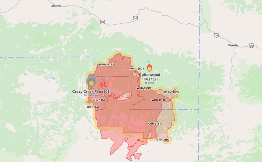
17-acre Cottonwood Fire on Ochoco National Forest sparked by lightning, not a spot fire from nearby Crazy Creek Fire
(Update: Fire confirmed to be lightning-caused)
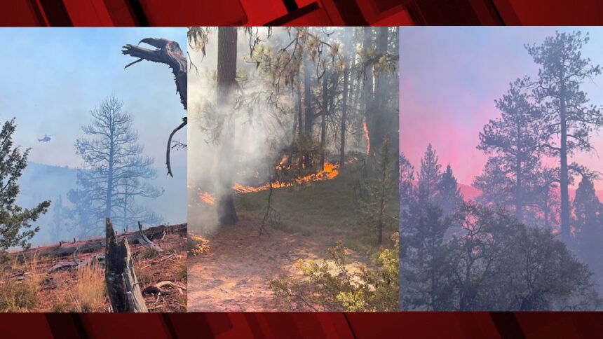
PAULINA, Ore. (KTVZ) – A new wildfire reported Saturday on the Ochoco National Forest east of the nearly 87,000-acre Crazy Creek Fire is not a spot fire from that over month-old blaze but a new start that officials confirmed Sunday was caused by lightning.
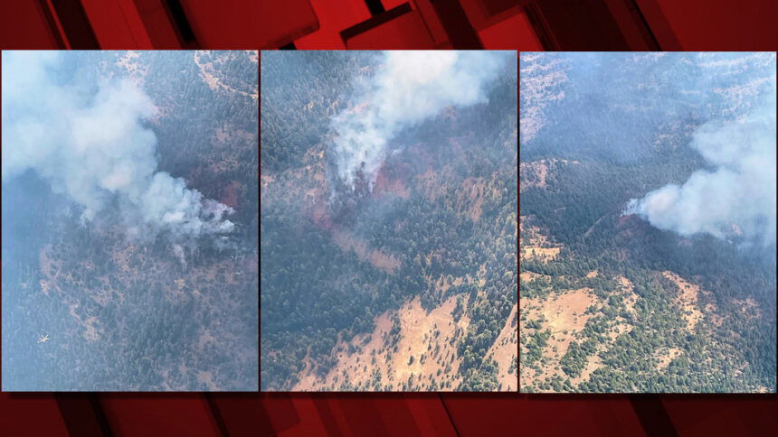
The Cottonwood Fire was reported around noon Saturday in the Rock Creek roadless area, two miles west of Spanish Peak, and officials said it had grown to 15 acres by 2:30 p.m. and 17 acres by Sunday morning.
The Cottonwood Fire was detected about 1 ¼ mile away from the Crazy Creek blaze, a Sunday update stated.
A hotshot crew was called in Saturday to assist initial attack resources that included a helicopter, two large air tankers, an air attack plane and ground crews, officials said. A VLAT (Very Large Air Tanker) also was ordered in.
No additional resources have been added Sunday, officials said. You can track updates on the fire on the Watch Duty website.
Much of the region and state is under a heat advisory until 9 p.m. Sunday for high temperatures reaching close to or above 100 degrees.
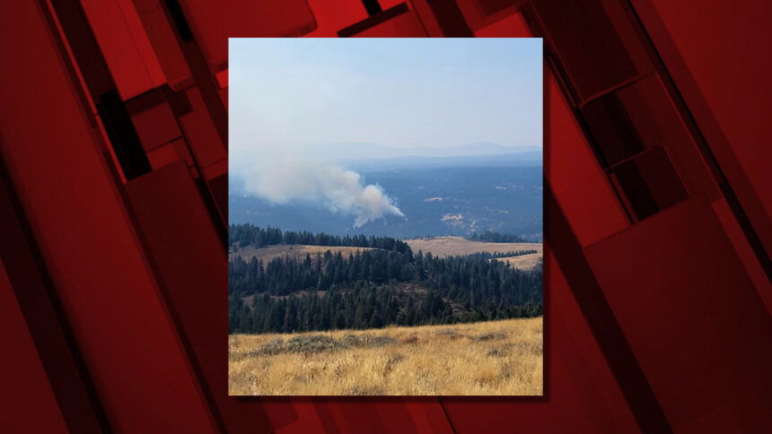
Here’s Saturday’s update on the lightning-sparked Crazy Creek Fire:
Crazy Creek Fire & Kitty Creek Fire Update – August 31, 2024
Acres: Crazy Creek –86,968; 93% contained Kitty Creek –73; 100% contained
Location: Crazy Creek: 5 miles north of Paulina, Oregon; 498/Kitty Creek: 7 miles south of Mitchell, Oregon
Start Date: July 22,2024 Personnel: 141 Cause: Lightning
Resources: 2 crews |4 engines | 5 water tenders | 1 skidder | 7 Excavators
Highlights: The warming and drying trend is expected to persist through the weekend, with minimum relative humidity dropping to 4% today. Conditions could lead to extreme fire behavior.
Yesterday, fire crews managed multiple flare-ups across the fire area. Today, the focus remains suppression repair, but crews are prepared to respond quickly to any changes in fire behavior. Expect increased smoke due to fire activity.
Future updates will be provided on Facebook and InciWeb only, unless significant changes occur. Stay informed by following these platforms for the latest information.
Closures: The Ochoco National Forest and Prineville District Bureau of Land Management (BLM) have implemented fire area closures.
Evacuations: Both the Crook and Wheeler County Sheriff’s Offices have reduced evacuation statuses in some areas. However, a Level 3 “Go” evacuation order remains in effect for areas within the closure boundaries, while areas approximately 1/2 mile around the perimeter of the closure are in Level 2 “Be Set” status. For the most current evacuation information, please visit the Crook County Sheriff's Office Facebook and webpage , the Wheeler County Facebook page and the Ochoco National Forest Facebook page.
Importance of Fire Prevention: All public lands in Central Oregon, including the Ochoco National Forest, are in Stage 2 Public Use (Fire) Restrictions. All open fires, including woodstoves and charcoal briquette fires, are prohibited. In times of high fire danger, it is crucial for everyone to follow prevention measures to avoid additional strain on overburdened resources.
More Information:
InciWeb: https://inciweb.wildfire.gov/incident-information/orocf-crazy-creek
Facebook: Facebook.com/CrazyCreekFire
Visit the official source for wildfire information in Central Oregon at centraloregonfire.org for wildfire updates or follow fire information on X/Twitter @CentralORfire. Call 9-1-1 to report a wildfire.
--
And here's Saturday's update on the Red Fire west of Crescent Lake Junction:
Size: 784 acres Location: 5 miles west of Crescent Lake Junction, OR County: Klamath
Start Date: July 17, 2024 Cause: Lightning Containment: 0% Total Personnel: 134
Activities – The section of shaded fuel break between Crescent Lake and Summit Lake continues to progress well and is anticipated to be complete by Saturday, September 7. The bulk of the work remaining along the final portion of shaded fuel break is slash removal being accomplished by local contractors with equipment and log trucks. Structure protection equipment remains in place along Crescent Lake and is being tested periodically. A 1.5-mile hose lay remains in place along the Whitefish Creek Trail on the southern edge of the fire to check fire spread as it approaches the trail.
Weather, Fire Behavior, and Smoke – Warmer and drier conditions persist across the fire area Saturday under clear skies. Continued warming and drying is expected though Sunday followed by a slight cool down until Wednesday, September 4 before another warming and drying trend sets in late next week. Isolated thunderstorms may impact the fire area Sunday into Monday bringing the potential for outflow winds and new fire starts. Fire behavior has increased due to warmer temperatures and low relative humidity, single and group tree torching is being observed. Smoke production has increased daily and is expected to increase today through the weekend. Depending on weather conditions, fire season often lasts through September into early October.
Incident Strategy – A full suppression strategy is being implemented utilizing indirect tactics, shaded fuel breaks, structure protection equipment, trail, and hose lay. Firefighter and public safety remain the incident management team’s highest priority in managing this fire. Expect to see increased fire activity due to the warmer and dryer conditions.
Closures – To provide for the safety of firefighters, equipment operators, and the public, the Deschutes National Forest emergency closure around Crescent Lake and in the Diamond Peak Wilderness is still in effect, including these areas: Forest Service Road 60 is closed, and road guards have been posted for public safety. More closure information is available at: https://www.fsa.gov/alerts/deschutes/alerts-notices/?aid=89091
Evacuations – The WILDFIRE! Level 1 – BE READY to Evacuate notice issued by Klamath County Emergency Management for Crescent Lake, Odell Lake, and Crescent Junction areas remains in effect (INCENDIO FORESTAL! Nivel 1 - ESTÉ PREPARADO para evacuar de las siguientes zonas: Crescent Lake, Odell Lake, Crescent Junction). Visit www.klamathcounty.org/300/emergency-management for more information or to sign up for alerts.
Fire Restrictions – Stage 2 Public Use Fire Restrictions – which prohibit open fires, including in developed campgrounds – remain in effect for the Deschutes National Forest. The Industrial Fire Precaution Level is currently Level III “Partial Shutdown.” Visit fs.usda.gov/detail/deschutes/home/?cid=stelprdb5297376 for more information.
Drone Restrictions – Aerial firefighting is suspended when unauthorized drones are in the area. Unauthorized drone use over a fire area poses serious risks to fire personnel and the effectiveness of wildfire suppression operations. If you fly, we can't.
