Fire officials see more danger amid heat, wind; Wiley Flat Fire tops 14,000 acres, Rail Ridge 61,000, Shoe Fly 20,000
(Update: Adding video, updates, comments by ODF , Central Oregon Type 3 Incident Management Team
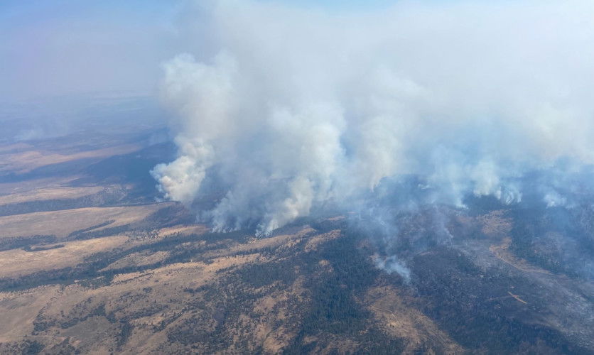
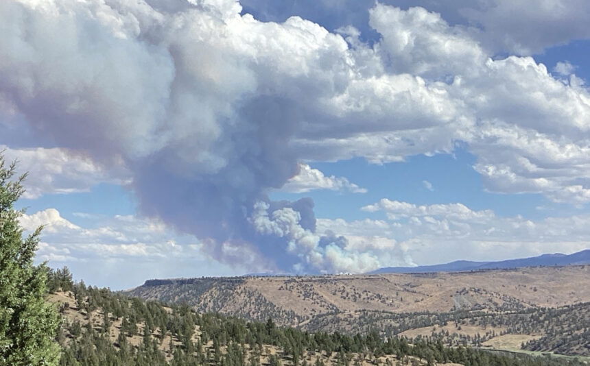
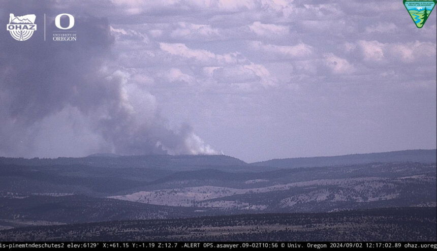
BEND, Ore. (KTVZ) – Several new lightning-sparked wildfires the blew up in hot, windy and stormy weather around the region on Labor Day, two jumping the Lower Deschutes and John Day rivers, kept growing fast Tuesday, racing across thousands of acres and prompting more evacuations.
"We still have active weather patterns throughout this next week that we're expecting, whether it's warm conditions, whether it's thunderstorms," said Natalie Weber, the public information officer for Oregon Department of Forestry Team 1 on the Shoe Fly Fire. "And so with that, it's going to bring the potential for new fires, or for fires to grow."
As of Tuesday morning, the ODF Incident Management Team 1 took over the response to the Shoe Fly Fire, which burned more than 20,000 acres in 24 hours.
"A lot of those erratic winds pushed the fire a little bit north and then to the southeast," Weber said. "So resources have been on the ground and working as quickly as they can to establish the line."
According to ODF, 11 homes were in a Level 2 BE SET evacuation indicating significant danger and 39 homes were in Level 3 GO NOW evacuation.
"A lot of times, it'll also bring kind of gusty and erratic winds, which can be very detrimental to the efforts that are going out on the fire," Weber said.
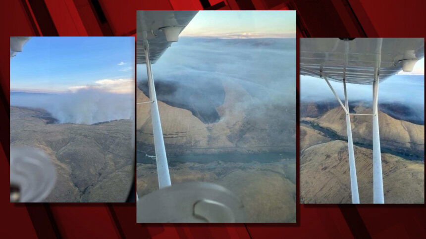
In Wasco County, the #OakCanyonFire grew to 15,000 acres but as of late Tuesday was 25% contained. Two outbuildings were damaged. All containment lines are holding on the fire, which jumped the Lower Deschutes River early on, and additional engines and a hotshot crew have been ordered, officials said.
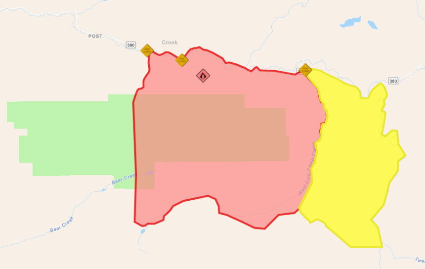
The Wiley Flat Fire in Crook County has burned 14,000 acres and as of Tuesday there was no containment.
"It is about 10 miles southeast of Post off Highway 380," said Isabella Isaksen, the public information officer for the Central Oregon Type 3 Incident Management Team. "And we currently have about 100 personnel assigned to the incident."
The Central Oregon Type Three Incident Management Team took command of the Wiley Flat Fire at 6 a.m. Tuesday.
The region is at Preparedness Level 4, meaning resources are spread thin due to the multiple fires.
"This continuation of the warming and drying trend has seen an increase in resource requests for initial attacks," said Isaksen.
Weber said, "We are still in the middle of a fire season, we still have that fire potential. And so it's really imperative that people just keep vigilant and be prepared still just because we do have that potential."
Authorities confirmed Tuesday that lightning sparked the Wiley Flat Fire near the Maury Mountains on the Ochoco National Forest that has burned 14,000 acres and prompted holiday evacuations of residents, campers and a fire lookout. The evacuation area widened on Tuesday.
The Crook County Sheriff's Office said Tuesday afternoon that the LEVEL 3 evacuation now encompasses the area from SE Pine Creek Road (FS RD 17) east to SE Camp Creek Road, south from Paulina Highway to the southern most portion of SE Camp Creek Road (including SE Tackman Road). This LEVEL 3 evacuation also covers Antelope Reservoir.
LEVEL 2 (BE SET) evacuation now encompasses SE Camp Creek Road east to the south fork Crooked River, from Paulina Highway south to roughly GI Ranch Road.
The updated map can be viewed here.
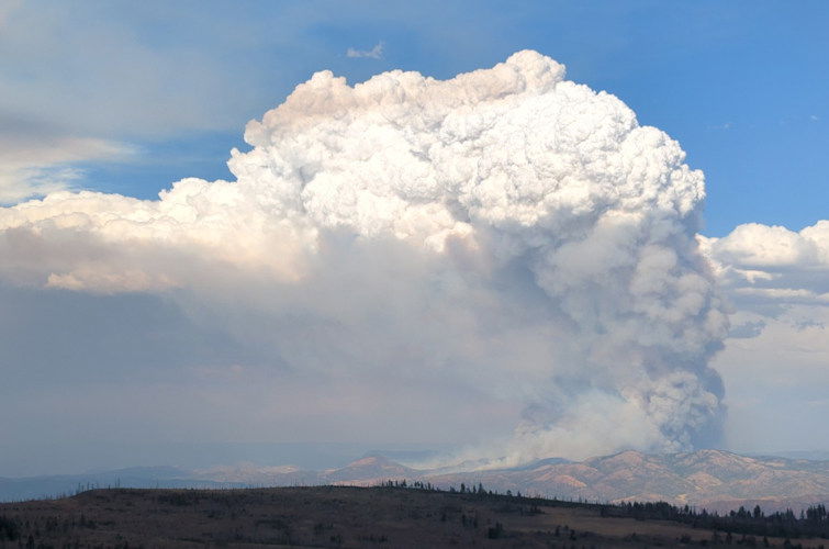
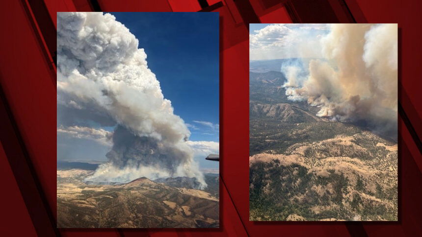
The largest fire in the region is the Rail Ridge Fire - here's the details released Tuesday evening:
RAIL RIDGE FIRE
DAILY UPDATE
Tuesday, September 3, 2024
Fire Information Line – 573-368-8227
Size: 61,433 acres Location: South fork of the John Day River near Martin Creek
County: Grant, Crook Start Date: Sep. 2, 2024 Containment: 0% Cause: Lightning
Total Personnel: 100
Dayville, Oregon — The Rail Ridge Fire is located on the South Fork of the John Day River near Martin Creek. The fire jumped the river yesterday and moved into the Murderers Creek drainage, where it continued to increase in size. Evacuations for all of Aldrich Mountain Proper were enacted.
Several lightning caused fires combined to become the Rail Ridge Fire. Wildfires designated as 778 Fire, 761 (Rail Ridge) Fire, 779 (Powell) Fire, and 796 (Black Canyon) Fire are now being managed as one wildfire response. Full suppression strategy will be used where possible and with firefighter and public safety in mind. The Southern Area Gray Incident Management Team, led by Incident Commander Mitch Ketron assumed command of the fire on Tuesday, September 3, at 1:00 PM (PST).
Along with firefighter safety, public safety is very important in managing this fire. If a resident is not already signed up for evacuation alerts, they can contact their local county Sheriff’s Office.
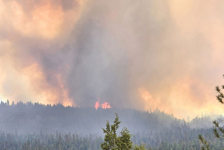
Yesterday’s Activities – After a lightning storm moved through the area on Monday Sep. 2, causing multiple starts, local resources quickly responded. This includes multiple federal, state, and Rural Fire Protection resources. Wind associated with the storm system caused the fire to spread quickly though the dry brush and grass.
Today’s Activities – Firefighters strengthened structure protection along perimeter of the fire and utilized natural barriers, existing roadways, and established fuel breaks to begin securing the perimeter of the fire. Conditions were very smoky, but some air operations were still possible. A flight of the fire’s perimeter was done to find the current acreage. Fire in many of the grassy areas went out as it hit existing barriers. Areas with thicker brush and timber continue to show fire activity.
Weather – Weather predictions for the next several days are calling for a warming and drying trend which means that fuels will continue to dry out, further increasing the likelihood of new ignitions and active fire behavior.
Evacuations – Evacuation zones update for the Rail Ridge Fire – Grant County:
- A Level 3, “Go Now” alert has been extended south of Murders Creek to Cougar Creek Gulch and East to Shake Table.
- A Level 2, “Be Set” alert has been issued for the area south of Wickiup Creek in the North, to Fields Creek in the East, to Murders Creek in the South, west to Shake Table.
- A Level 1, “Be Ready” has been extended North to Hwy 26 and East to Fields Creek and South to Wickiup Creek.
For regular updates, visit the Grant County Emergency Management Facebook page at
https://www.facebook.com/p/Grant-County-Emergency-Management-100068819321423/;
call the information line at 541-575-2885; or email the Emergency Operations Center at GCEOC@grantcounty-or.gov.
Closures:
The Malheur National Forest has enacted a closure order for sections of the Blue Mountain Ranger District for public safety.
Visit the Oregon Department of Emergency Management website to view a map of active fires (and evacuation areas) at https://oregon-oem-geo.hub.arcgis.com/.
Fire Restrictions –
- All public lands in Central Oregon, including the Ochoco National Forest, are in Stage 2 Public Use (Fire) Restrictions. All open fires, including woodstoves and charcoal briquette fires, are prohibited.
- Malheur National Forest Fire Restrictions can be viewed on the Forest’s website.
For more information, visit CentralOregonFire.org or the Ochoco National Forest’s website. Smoke from the Rail Ridge Fire continues, and maps and air quality information are always available on https://fire.airnow.gov/. Please help firefighters by following all local regulations, found here: https://www.oregon.gov/odf/fire/pages/restrictions.aspx. Additional wildfire prevention tips are available at www.keeporegongreen.org.
If you fly, we can’t. Unauthorized drone flights (UAS) pose serious risks to firefighter and public safety and the effectiveness of wildfire suppression operations. Aerial firefighting is suspended when unauthorized UAS are in the area, allowing wildfires to grow larger.
Fire officials urge everyone to do their part to avoid human-caused wildfires. Human-caused fires are avoidable whereas naturally occurring fires are not. Remember, one less spark means one less fire that could put our wildland firefighters and communities at risk.
--
Shoe Fly Fire grows overnight, ODF Team 1 takes command
MITCHELL, Ore. – As of 6 p.m. Tuesday, September 3, Oregon Department of Forestry’s Incident Management Team 1 assumed command of the Shoe Fly Fire. The fire was first reported early Monday morning, burning in grass, brush and timber north of Highway 26 near Girds Creek.
Firefighters from ODF’s Central Oregon District, Wheeler County Fire and Rescue, Bureau of Land Management and Twickenham Rangeland Fire Protection Association initially responded, along with local landowners.
Numerous fires were reported following thunderstorms late Sunday evening and overnight. Many of these fires were caught during initial attack. Near record-dry fuel conditions challenged firefighters on the Shoe Fly Fire, combined with limited available resources and erratic winds from passing thunderstorms on Monday. This resulted in growth on all flanks of the fire and prompted burning throughout the night. Infrared imagery Tuesday morning mapped the fire at 20,247 acres.
Two structural task forces from the Oregon State Fire Marshal are working for the Wheeler County Fire Defense Board to provide structural protection for homes near the fire. For public safety, the Wheeler County Sheriff has issued evacuation notices for residents around the fire. More information on current evacuations is available below.
Tonight, firefighters will establish access points into the fire, identify areas for fireline development, and build direct control lines where possible. Numerous fires in the area continue to make resources scarce; additional crews, engines, and equipment have been ordered.
The fire is burning on private and BLM land protected by ODF, and private rangelands protected by Twickenham RFPA and Wheeler County Fire and Rescue.
Evacuations: Evacuation notices are in effect for areas around the fire. An evacuation map is available at: https://tinyurl.com/RAPTOR-Evacuation-Info
--
Track fire updates at Watch Duty.
Here's Monday morning's update on the Wiley Flat fire:
Wiley Flat Fire Update – September 3, 2024
Acres: 10,000 Acres; 0% Contained Cause: Under investigation
Location: 10 Miles southeast of Post, off Highway 380.
Highlights: This morning at 6 a.m., the Central Oregon Type 3 Incident Management Team, led by Incident Commander Cason McCain, assumed command of the Wiley Flat Fire.
Yesterday, firefighters focused their efforts on structure protection, working diligently to safeguard homes and critical infrastructure in the immediate area.
Today, crews will persist in their structure protection efforts while also scouting for opportunities to establish control lines around the fire’s perimeter.
With a warming and drying trend expected to influence fire behavior in the coming days, firefighters are closely monitoring conditions and adjusting their strategies as necessary to maintain safety and effectiveness in their operations.
Evacuations: Crook County Sheriff’s Office determined that that LEVEL 3 evacuation would expand to SE Camp Creek Road and south to SE Tackman Road. For the most current evacuation information, please visit the Crook County Sheriff’s Office webpage and Facebook page.
The Ochoco National Forest has implemented a partial forest closure. More information can be found at https://www.fs.usda.gov/alerts/ochoco/alerts-notices/?aid=89203
Visit the official source for wildfire information in Central Oregon at centraloregonfire.org for wildfire updates or follow fire information on X/Twitter @CentralORfire. Call 9-1-1 to report a wildfire.
--
The Crook County School District kept Paulina School closed as a precaution on Tuesday, what would have been the first day of classes, due to wildfires and evacuations in the area.
Wiley Flat was one of four large new wildfires that had burned a total of 30,000 acres by early Tuesday. Add in Sunday's fast-growing Copperfield Fire near Chiloquin, and the tally is close to 34,000 acres.
Matthew Draxton will be tracking the fires and talking with officials about the new round of blazes. He'll report on NewsChannel 21 Fox @ 4 and at 5 on NBC.
Here is Central Oregon fire managers' Monday night update on the new burst of wildfires:
Central Oregon Experiences an Increase of Lightning Strike Fires Over the Labor Day Weekend
Central Oregon — Central Oregon received widespread lightning storms with minimal rainfall over the Labor Day weekend. Vegetation remains dry and susceptible to ignition due to the extended drought leading to an increase in ignitions from lightning strike fires over the last 24 hours.
These new fires ranged in size from several acres up to the largest at over 8,000 acres. Some occurred in remote areas, but several occurred near homes, other structures, and campsites resulting in evacuations. The gusting winds today caused long-range spotting forcing two fires to jump across rivers. These wind-driven fires grew at a rapid rate of spread throughout the day resulting in very large acreage increases. The largest fires today include:
Wiley Flat Fire: 1,200+ acres, located near Maury Mountains, with evacuations in place north of the Maury Mountains. Central Oregon Team 3 will assume command of this fire Tuesday at 7:00am.
Oak Canyon Fire: size – 4,000+ acres, located near Deschutes River, north of White River Falls State Park in Tygh Valley.
Shoe Fly Fire: size – 8,000 acres, located north of Hwy 26 in Baldy Block near Girds Creek. Oregon Department of Forestry Team 1 will assume command of this fire Tuesday at 10:00am.
Rail Ridge Fire: size – 8,000+ acres, located on the south fork of the John Day River near Martin Creek, jumped the John Day River, and is now in the Murderers Creek drainage, with evacuations for all of Aldrich Mountain Proper. The Southern Area Grey Team 3 will take command of this fire Tuesday morning.
It is recommended that residents contact their local county Sheriff’s Office to ensure they are signed up for evacuation alerts in their area.
Weather predictions for the next several days are calling for a warming and drying trend which means that fuels will continue to dry out, further increasing the likelihood of new ignitions and active fire behavior. Fire officials urge everyone to do their part to avoid human-caused wildfires. Human-caused fires are avoidable whereas naturally occurring fires are not. Remember, one less spark means one less fire that could put our wildland firefighters and communities at risk.
Visit the official source for wildfire information in Central Oregon at centraloregonfire.org for wildfire updates and public use fire restrictions or follow fire information on X/Twitter @CentralORfire. Call 9-1-1 to report a wildfire. For smoke and air quality information, visit fire.airnow.gov.
--
Earlier info:
Multiple air and ground resources responded to the Wiley Flat Fire, which burned about 100 acres by early afternoon “with active spotting” and grew to some 1,200 acres by evening, prompting evacuations of the Wiley Flat Campground and Power Point Lookout, followed by private properties north of the Maury Mountains.
The Crook County Sheriff’s Office issued an evacuation alert on Facebook that said SE Drake Park Road (Forest Service Road 16) was under a Level 3 GO NOW evacuation, extending east about five miles. A Level 2 GET SET area extended from Drake Creek Road west to Pine Creek Road (Forest Service Road 17), from Paulina Highway south about five miles, in line with the Level 3 zone.
“The winds out in this area are strong and are moving the fire fast,” the sheriff’s office said as deputies made evacuation notifications in the area.
Crook County's evacuation zones map can be viewed here.
Air and ground resources working to suppress the fire included two helicopters, four SEATs (Single-Engine Air Tankers), a lead plane, two LATs (Large Air Tankers) and bulldozers.
New thunderstorms moved through the area Monday afternoon, including a strong storm near Redmond that prompted a National Weather Service special weather statement around 3 p.m. Forecasters advised the storm was moving north at 25 mph, carrying wind gusts up to 50 mph.
Meanwhile, along the Lower Deschutes River, crews were battling the Oak Canyon Fire, at last report over 4,000 acres. Officials said it had jumped the Deschutes River and winds were pushing it southeast toward Maupin.
The fire broke out east of Tygh Valley and north of Maupin and White River Falls State Park. Evacuations were in place along Segment 3 of the lower Deschutes for all campgrounds north of the Pine Tree boat ramp. The cause has yet to be determined.
A Large Air Tanker (LAT) made drops on the fire, assisted by two Type 1 helicopters, a Type 2 helicopter and more ground crews. VLATs (Very Large Air Tankers), a lead plane and dozer strike teams were ordered.
In Wheeler County, several engines and air attack were working to stop the lightning-sparked Shoe Fly Fire, reported early Monday morning and which grew to an estimated 8,000 acres in a remote area about nine miles north of Highway 26 in Baldy Block, near Girds Creek.
"Winds are pushing the fire south/southeast," officials said early Monday evening. Two task forces of resources, a Type 1 helicopter, and ODF Incident Management Team 1 have been ordered.
The area of the Six Shooter Ranch was under Level 3 GO NOW evacuation, with other areas under Level 2 BE SET status, the sheriff’s office reported.
The largest new lightning-sparked fire, the Rail Ridge Fire, quickly grew to 8,000-plus acres, jumped the south fork of the John Day River in several locations and burned into the Murderers Creek drainage. Several engine crews were on scene, with bulldozers and air resources ordered.
That fire jumped the John Day River Monday afternoon, and the Grant County Sheriff's office said it was enforcing evacuations for all of Aldrich Mountain proper.
There were also smaller new fires being reported Monday afternoon, including Incident 779, southwest of Powell Mountain and northwest of Ashley ridge, at 30-plus acres at last report and spreading fast. BLM engine crews were on scene and a VLAT (Very Large Air Tanker) was ordered.
Other new fires were being spotted by air attack and tackled at small sizes, some from the new round of lightning and thunderstorms, including two east of the Wiley Flat Fire: Incident 791, at two to three acres with a strong northwest wind, and Incident 793 at one acre, moving east into timber.
Track these and other Oregon wildfires at https://app.watchduty.org/

