More heat to test lines, tactics on containing several large lightning-sparked fires amid progress, new blazes
(Update: Shoe Fly Fire update; Rail Ridge Fire update; new, expanded Ochoco Natl. Forest, BLM closures)
POST, Ore. (KTVZ) -- Hundreds of firefighters working to build lines, protect structures and stop or slow the spread of several lightning-sparked wildfires across the region are reporting good progress but also face a return of hotter weather in coming days.
Good progress was made on some fires, including the Oak Canyon Fire, which was 75% contained at 15,170 acres. Officials said Wednesday that campgrounds along the Lower Deschutes River from Maupin to Shears Bridge had reopened to overnight camping and recreation, while other recreation along the lower access road, including Buck Hollow to Max Canyon, reopen to access at 6 a.m. Thursday.
Meanwhile, new wildfires continue to emerge, such as the Hawley Ridge Fire (Incident 793), southwest of Paulina, at about 200 acres Tuesday morning, with Level 3 evacuations, and the Two Cabin Fire, also 200 acres, northeast of Monument, as well as the 50-acre Studhorse Fire in eastern Jefferson County.
Meanwhile, more evacuations have been ordered on the 14,000-acre Wiley Flat Fire in Crook County and on the 61,000-acre Rail Ridge Fire., and new or expanded closure areas around the fires have been announced.
Gov. Tina Kotek's office said that as of Tuesday, there were 21 large uncontained fires burning across the state.
--
Here are the latest daily reports. Track updates at https://app.watchduty.org/
Wiley Flat Fire update - Wednesday, Sept. 4
Acres: 14,760 Acres; 0% Contained
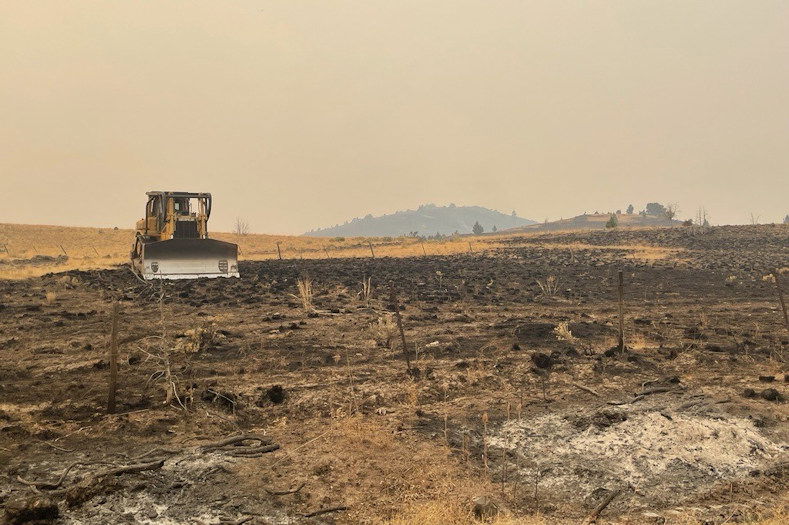
Location: 10 Miles southeast of Post, off Highway 380
Start Date: September 2,2024 Personnel: 160 Cause: Lightning
Resources: 4 crews | 5 engines | 2 water tenders | 1 skidgine | 4 dozers
Highlights: Firefighters continue structure protection efforts while scouting control line opportunities around the Wiley Flat Fire perimeter.
Yesterday, firefighters concentrated on structure protection, working diligently to safeguard homes and critical infrastructure in the immediate area. Crews successfully established an anchor point on the west end of the fire perimeter, providing a strong foundation for future containment efforts.
Today, operations will continue to prioritize structure protection while utilizing both aerial and ground resources to scout for potential control line locations around the fire’s perimeter.
Weather: Dry weather is expected with a high of 90 degrees. Southeast winds of 5 to 10 miles per hour and a minimum humidity of 9 to 14 percent.
Evacuations: LEVEL 3 evacuation now encompasses the area from SE Pine Creek Road (FS RD 17) east to SE Camp Creek Road, south from Paulina Highway to the southernmost portion of SE Camp Creek Road (including SE Tackman Road). This LEVEL 3 evacuation also covers Antelope Reservoir.
LEVEL 2 evacuation now encompasses SE Camp Creek Road east to the south fork Crooked River, from Paulina Highway south to roughly GI Ranch Road. For the most current evacuation information, please visit the Crook County Sheriff’s Office webpage and Facebook page.
Importance of Fire Prevention: All public lands in Central Oregon, including the Ochoco National Forest, are in Stage 2 Public Use (Fire) Restrictions. All open fires, including woodstoves and charcoal briquette fires, are prohibited. In times of high fire danger, it is crucial for everyone to follow prevention measures to avoid additional strain on overburdened resources.
The Ochoco National Forest has implemented a partial forest closure. More information can be found at https://www.fs.usda.gov/alerts/ochoco/alerts-notices/?aid=89203
Visit the official source for wildfire information in Central Oregon at centraloregonfire.org for wildfire updates or follow fire information on X/Twitter @CentralORfire. Call 9-1-1 to report a wildfire.
--
Shoe Fly Fire - Wednesday evening update
| SHOE FLY FIRE Evening Update: September 4, 2024 | Fire Information Links: https://linktr.ee/odfteam1 Phone: (541) 362-4119 Email: IMT1.FireInfo@ODF.oregon.gov |
FIRE AT A GLANCE
Total Size: 20,699 acres
Total Containment: 1%
Cause: Lightning
Estimated Cost: $65,000
County Evacuations
Wheeler County Sheriff’s Office has issued evacuation notices, info available here: https://tinyurl.com/RAPTOR-Evacuation-Info
Road Closures
For road closures, visit:
https://www.tripcheck.com
Fire Restrictions
ODF: www.oregon.gov/odf/fire/pages/restrictions.aspx
ODF Incident Commander:
Joe Hessel
Incident Management Team 1
ODF Team 1 assumes command of Two Cabin Fire, Shoe Fly Fire challenges firefighters
MITCHELL, Ore. – Today, firefighters on the Shoe Fly Fire continued to work strengthening the existing fireline around the perimeter. On the west side of the fire near Flock Mountain, the fire moved outside the fireline; firefighters are working to re-establish control lines around this area. Helicopters are being used to moderate fire behavior there, as well as other parts of the fire, supporting firefighters on the ground. Tonight, efforts will continue to focus on building fireline in the Flock Mountain area and use strategic firing operations to remove fuel between the fire perimeter and constructed firelines across the fire.
ODF’s Central Oregon District transferred command of the Two Cabin Fire to ODF Team 1 tonight at 6 p.m. The fire, estimated to be 200 acres, is burning northeast of Monument. A dozer line has been established on approximately half of the fire. Firefighters will staff a night shift tonight, working to mop up and hold the fire within the existing footprint. The cause of the fire is under investigation.
As a precautionary measure to provide for firefighter safety or due to wildfire damage to infrastructure, power lines servicing a communications site in the Flock Mountain area may be de-energized, causing a disruption of service in the local area.
Landowners, rangeland protection association members, contractors, and local fire districts are integral to the suppression efforts on both fires. Today, the Shoe Fly Fire was staffed with nearly 400 firefighters, working with these partners. Additional resources continue to arrive, bolstering both day and night shifts.
Hot, dry weather is expected to continue, with low overnight humidity recovery. Record dry fuel conditions have the potential for rapid fire growth from any spotting outside the fireline. Winds are expected to come from the northeast, transitioning to east throughout the day into the evening.
Oregon State Fire Marshal structural task forces are working for the Wheeler County Fire Defense Board, providing structure protection for homes near the fire. Evacuation notices for residents around the fire continue to be evaluated by the Wheeler County Sheriff, Wheeler County Fire Defense Board Chief, and Team 1 Operations personnel. More information on current evacuations is available at https://tinyurl.com/RAPTOR-Evacuation-Info
--
RAIL RIDGE FIRE
DAILY UPDATE
Wednesday, September 4, 2024
Fire Information Line – 573-368-8227
centraloregonfire.org x.com/CentralORFire
Size: 61,433 acres Location: South Fork of the John Day River near Martin Creek
County: Grant, Crook, Wheeler Start Date: Sep. 2, 2024
Containment: 0% Cause: Lightning Total Personnel: 150
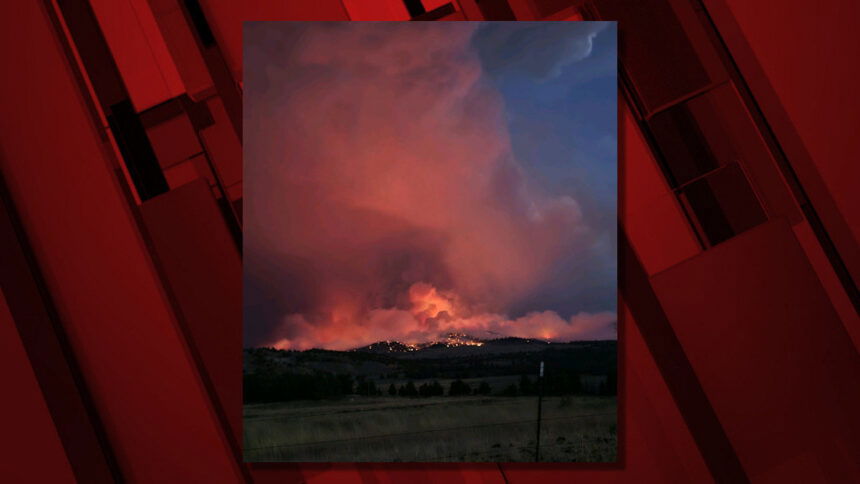
Dayville, Oregon — The Rail Ridge Fire started near the South Fork of the John Day River around Martin Creek and quickly moved into the Murderers Creek drainage. Evacuations for all of Aldrich Mountain remain in effect.
Several lightning-caused fires combined with the Rail Ridge Fire. Wildfires designated as 778 Fire, 761 (Rail Ridge) Fire, 779 (Powell) Fire, and 796 (Black Canyon) Fire are now being managed as one wildfire response. Full suppression strategy will be used where possible and with firefighter and public safety in mind. If a resident is not already signed up for evacuation alerts, they can contact their local county Sheriff’s Office.
Today’s Activities – Firefighting operations focused on aggressively building fire perimeter where safe for fire personnel. Natural barriers, existing roadways, and established fuel breaks continued to be utilized to stop or slow spread along the perimeter of the fire. Conditions remained too smoky for aircraft operations, but smoke shading and light winds provided opportunity to make progress in slowing fire spread and establishing control lines for upcoming operations
Continued operations tonight – This afternoon and into the night, strategic burning operations will be utilized from control lines to remove unburned fuels between defensible barriers and the active fire front. Continued smoke and some fire may be visible from nearby communities tonight. On the north end, the focus will be stopping the fire from spreading into the Deep Creek drainage to keep the fire away from structures in this area. Along the west side of the Rail Ridge fire, firing operations will be used in the same way to connect lines that were built over the last few days. Crews will continue strategic structural point protection, as safe to do, so while continuing to stop the fire’s spread along these planned lines.
Weather – A warming and drying trend will continue to dry out fuels, further increasing the likelihood of new ignitions and active fire behavior. On Wednesday, the temperature will reach the high 80s, with humidity as low as 9%, and light easterly winds around 5 mph.
Evacuations – Evacuation zones update for the Rail Ridge Fire –
Grant County:
- A Level 3, “Go Now” alert has been extended south of Murders Creek to Cougar Creek Gulch and East to Shake Table.
- A Level 2, “Be Set” alert has been issued for the area south of Wickiup Creek in the North, to Fields Creek in the East, to Murders Creek in the South, west to Shake Table.
- A Level 1, “Be Ready” has been extended North to Hwy 26 and East to Fields Creek and South to Wickiup Creek.
- For regular updates, visit the Grant County Emergency Management Facebook page at https://www.facebook.com/p/Grant-County-Emergency-Management-100068819321423/; call the information line at 541-575-2885; or email the Emergency Operations Center at GCEOC@grantcounty-or.gov.
Wheeler County:
- The Level 3, “Go Now” alert has been extended North along South Fork Rd to Smokey Creek on East and Johnson Creek in the West.
- The Level 2, “Be Set” alert has been expanded to include everything north of Smokey Creek and Johnson Creek to Hwy 26, to include the town of Dayville, East to Marks Creek.
- For regular updates, visit the Grant County Emergency Management Facebook page at https://www.facebook.com/p/Grant-County-Emergency-Management-100068819321423/; call the information line at 541-575-2885; or email the Emergency Operations Center at GCEOC@grantcounty-or.gov.
- Access the active GIS map: https://oregon-oem-geo.hub.arcgis.com/.
Closures:
The Malheur National Forest has enacted a closure order for sections of the Blue Mountain Ranger District for public safety.
Ochoco National Forrest has multiple closure orders in areas affected by this and other wildfires. Visit the Forest’s website at www.fs.usda.gov/ochoco to see current closures.
Visit the Oregon Department of Emergency Management website to view a map of active fires (and evacuation areas) at https://oregon-oem-geo.hub.arcgis.com/.
Fire Restrictions –
- All public lands in Central Oregon, including the Ochoco National Forest, are in Stage 2 Public Use (Fire) Restrictions. All open fires, including woodstoves and charcoal briquette fires, are prohibited.
- Malheur National Forest Fire Restrictions can be viewed on the Forest’s website.
For more information visit CentralOregonFire.org or the Ochoco National Forest’s website. Smoke from the Rail Ridge Fire continues, and maps and air quality information are always available on https://fire.airnow.gov/. Please help firefighters by following all local regulations, found here: https://www.oregon.gov/odf/fire/pages/restrictions.aspx. Additional wildfire prevention tips are available at www.keeporegongreen.org.
--
Paulina Complex Closure Expanded Due to Increased Fire Activity
Officials Urge Caution as Fire Risks Remain High
Prineville, Ore., August 29, 2024— The Ochoco National Forest & Crooked River National Grassland, in coordination with the Prineville District Bureau of Land Management (BLM), fire management officials, and the Crook, Wheeler, and Grant County Sheriff’s Offices, have jointly made the decision to expand the Paulina Complex Fire Area Closure due to multiple fires across the landscape.
This decision comes after careful evaluation of the current fire situation, containment progress, and safety assessments conducted by fire management officials and local authorities. These fires have significantly impacted the region, and new fire activity necessitates an expansion of the closure area for public safety.
Key Changes to the Closure:
- Expanded Closure Boundaries: The closure area has been expanded to account for increased fire activity and new fire threats. A detailed map of the updated closure area is available on the Ochoco National Forest website and BLM website.
- Continued Safety Precautions: Active fire behavior and unstable conditions remain across the fire landscape. Increasing fire activity, particularly with forecasted warmer and drier weather, poses ongoing threats, and the public is urged to respect all closures and safety signs.
Ongoing Efforts and Safety Reminders:
Fire management officials, in collaboration with local authorities, continue to closely monitor the fire area. Firefighters are actively engaged on the ground to manage fire suppression efforts and address any emerging risks.
We recognize the impact these closures are having on our communities, particularly during hunting season. We appreciate your patience and cooperation as we work together to manage these fires and protect public safety.
Public and firefighter safety remains our top priority, and we thank the community for their understanding and support during this challenging fire season.
Crook, Wheeler, and Grant County Evacuation Updates:
- The Crook County Sheriff’s Office has lowered evacuation levels from Level 3 to Level 2 in areas south of Highway 380. However, areas around SE Puett Road and the perimeter of the Crazy Creek Fire remain under Level 3 (Go Now) status. For the latest updates, visit the Crook County Emergency Management website and Crook County Sheriff’s Office Facebook page.
- Wheeler County: The Wheeler County Sheriff’s Office continues to monitor fire activity. The area near Beaver Creek Road remains at Level 2 (Be Set), with areas around the fire perimeter still under Level 3 (Go Now) orders. Visit the Wheeler County Sheriff’s Office Facebook page for real-time updates.
- Grant County: A Level 3 “Go Now” alert remains in effect for areas around the Rail Ridge Fire, with Level 2 “Be Set” and Level 1 “Be Ready” advisories for other areas. For the most up-to-date evacuation information, visit the Grant County Emergency Management Facebook page.
For information on the Ochoco National Forest & Crooked River National Grassland, please visit our website https://www.fs.usda.gov/ochoco and our Facebook Page.
--
Maury Mountains Closure Due to Ongoing Fire Activity
Ochoco National Forest, BLM, and Crook County Sheriff’s Office coordinate closures for public safety
Prineville, Ore., September 4, 2024— The Ochoco National Forest, in coordination with the Prineville District Bureau of Land Management, Crook County Sheriff’s Office, and fire management officials, has implemented an emergency closure for the east side of the Maury Mountains due to ongoing wildfire activity. These closures, along with those enacted on nearby BLM-managed lands, are necessary to protect public safety and to ensure that firefighters can safely carry out suppression efforts. Evacuation orders are currently in place for parts of Crook County.
These closures are essential for ensuring public safety and enabling firefighters to operate without obstruction. Heavy equipment, including bulldozers and water tenders, must access narrow, hazardous roads, while aerial resources such as helicopters and air tankers are conducting operations. Unauthorized individuals in the area increase the risk of accidents and interfere with firefighting activities. Additionally, erratic fire behavior, falling trees, and debris further heighten the danger.
We acknowledge that these closures affect the public, especially hunters and other recreationists who frequent the Maury Mountains during this season. This decision was not made lightly but is necessary to safeguard both the public and firefighting personnel.
We appreciate the public’s understanding and cooperation during this time. The closure will remain in place until conditions improve, and it is deemed safe to lift restrictions.
For detailed maps and additional information regarding these closures, visit the Ochoco National Forest website and the BLM website.
Evacuations:
Evacuations have been issued for areas from SE Pine Creek Road (FS RD 17) east to SE Camp Creek Road, extending south from Paulina Highway to the southernmost portion of SE Camp Creek Road, including SE Tackman Road and Antelope Reservoir. Additionally, Level 2 “Be Set” evacuations are in effect from SE Camp Creek Road east to the South Fork Crooked River, from Paulina Highway south to approximately GI Ranch Road. For the latest information, please visit the Crook County Sheriff’s Facebook and webpage.
Visit the official source for wildfire information in Central Oregon at centraloregonfire.org for wildfire updates or follow fire information on X/Twitter @CentralORfire. Call 9-1-1 to report a wildfire.
