New wildfires keep crews on the move: Little Lava Lake Fire hits 1,000 acres; Firestone, Flat Top fires, evacuation zones grow
(Update: Firestone, Flat Top fire evacuations grow;, adding video, comments by C.O. fire officials, residents)
BEND, Ore. (KTVZ) -- Firefighters battled a growing number of larger, older and new lightning-sparked wildfires across Central Oregon and nearby areas on Sunday, with resources stretched thin. Many were caught small, but on the larger ones, some evacuation zones expanded, with area emergency closures in place.
Central Oregon fire officials gave this update Sunday evening:
Firefighters continue to respond to numerous lightning-caused wildfires across central Oregon. The majority are concentrated south of Bend across Deschutes County on the Deschutes National Forest and range in size from 1/10 of an acre to 14,000 acres. The largest fires include:
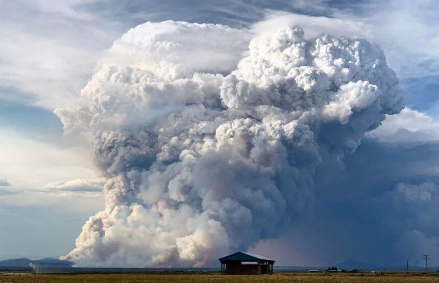
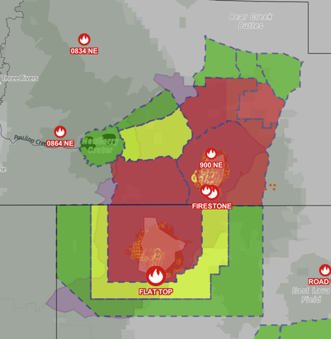
Firestone Fire –6,500 acres, located southeast of Paulina Lake. This fire along with the Flat Top Fire will be managed by Central Oregon Type 3 Incident Management Team (IMT).
Flat Top Fire– 13,680+ acres, located southeast of Newberry Caldera on the Deschutes National Forest, and burning in brush and timber. Multiple air and ground resources are responding.
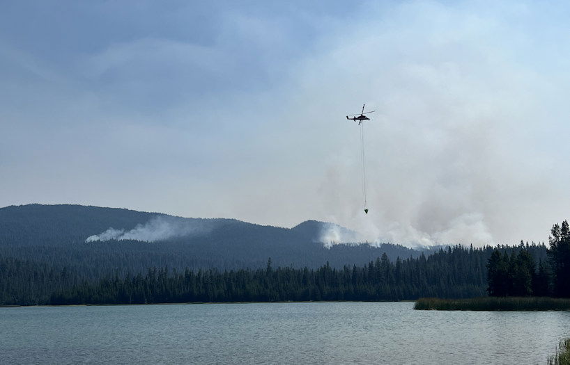
Backside Fire – 80 acres, located west of Mt. Bachelor on the Deschutes National Forest. Multiple air and ground resources are responding. Mt. Bachelor Resort and recreational infrastructure are considered threatened. A CIMT (Complex Incident Management Team) will manage this fire.
Little Lava Fire – 1000+ acres, located approximately 2 miles SE of Little Lava Lake. Multiple ground resources including engines and dozers are responding.
Mt. Bachelor remained closed for a second day due to the Backside Fire, while evacuations widened around the Firestone and Flat Top fires in eastern Deschutes and northern Lake counties. Resort officials expect it to reopen Thursday.
The Backside Fire, 80 acres as of Sunday, broke out about a mile west of the resort and led emergency managers to close a wide swath of the Cascade Lakes area on Saturday.
"This fire is occurring in the Mt. Bachelor resort area," Ludie Bond, Central Oregon Fire Management Services' public information duty officer said Sunday. "There's also a lot of recreational infrastructure in near and around where this area is, so that's a real concern about any potential damage or loss."
A Complex Incident Management Team is expected to take command of the firefighting effort on Monday, officials said Sunday on their X (Twitter) feed.
When there's fires in the area, and the skies turn smoky and air quality unhealthy, Central Oregonians understand that plans need to be adjusted.
Bend resident Anahi Kyniston said Sunday she's "very thankful that smoke later this year, feels like later. I've just make sure to not go out when it's super-smoky, like the AQI (air quality index) has been pretty high."
Bend resident Rob Evans said, "I take advantage of where the air clears to do more aerobics stuff, like working outside and mowing and things like that, and spend more time indoors when it's like this. So it's not fun to be out. "
The crews fighting the Backside Fire on Sunday included two helicopters and one air attack plane, a small aircraft assisting with aerial fire suppression.
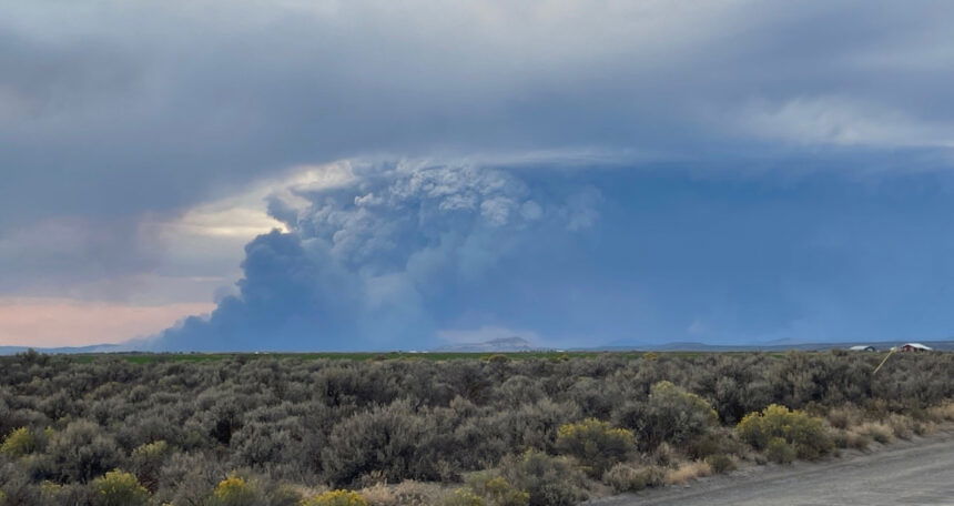
One of the new fires reported in the area, the Little Lava Fire, was reported Saturday evening south of the Backside Fire and burned about 1,000 acres 2 miles southeast of Little Lava Lake. Officials said it "should be visible from many recreation sites in the area." Ground resources included a 20-person hand crew and a bulldozer.
Track the many fires across the region at Watch Duty.
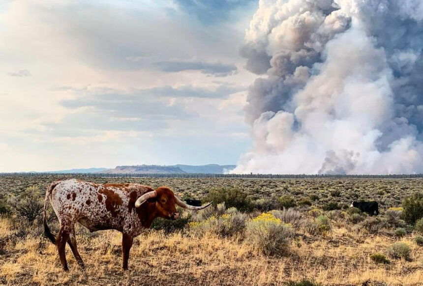
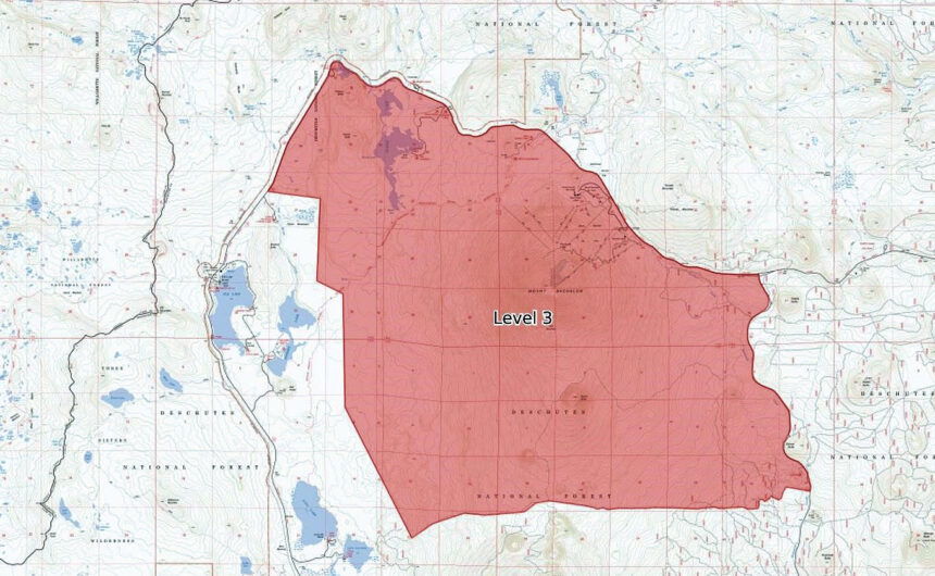
In eastern Deschutes and northern Lake counties, the Firestone Fire continued its rapid growth, reaching 6,500 acres as of Sunday. An incident management team was called in to help oversee that fire and the larger, nearly 14,000-acre Flat Top Fire to the south, located north of Flat Top and Flat Rock on the Deschutes National Forest.
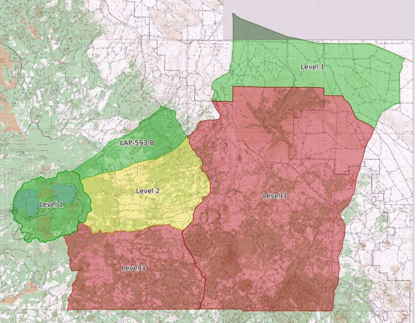
Level 1, 2 and 3 evacuation zones for the two large fires straddle the Deschutes-Lake county line:
Among other blazes large wildfires in the area, the Wiley Flat Fire in Crook County remains active and grew by Sunday to 26,801 acres and was 3% contained, with expanded evacuations, while the Rail Ridge Fire in Crook, Grant and Wheeler counties topped 135,000 acres and the Shoe Fly Fire in Wheeler County, at 26,409 acres, was 19% contained by Sunday. (see full updates below).
Somewhat cooler temperatures and lighter winds were helping crews on some blazes, but the smoky, hazy skies also were making for poor visibility, which can hamper aerial firefighting efforts.
Bond added, "There are currently 625,000 acres actively on fire between Oregon and Washington and over 8,400 personnel are responding. That includes 10 Complex Incident Management Teams, three Oregon Department of Forestry teams and one Oregon State Fire Marshal's team."
--
2:40 p.m. Sunday update from Deschutes County Sheriff's Office: Sgt. Nathan Garibay:
Due to continued growth and expected fire, fire managers have recommended adjustments to the evacuation levels for areas around the Firestone and Flat Top fires. These fires are burning in southern Deschutes County and northern Lake County.
Current Level 3 (Go Now):
Pine Mountain and areas south to the Lake County line. Additionally, areas west of FS 18 Rd (China Hat Rd) south of FS Rd 21 to the Lake County line.
Level 3: Means “GO” evacuate now. Leave immediately! Danger to your area is current or imminent, and you should evacuate immediately. If you choose to ignore this advisement, you must understand that emergency services may not be available to assist you further. DO NOT delay leaving to gather any belongings or make efforts to protect your home. This will be the last notice you receive.
Current Level 2 (Be Set):
Area north of FS Rd 21 to FS Rd 1835 between Newberry Caldera and FS Rd 18 (China Hat Rd).
Level 2: Means “BE SET” to evacuate. You must prepare to leave at a moment’s notice. This level indicates there is significant danger to your area, and residents should either voluntary relocate to a shelter or with family and friends outside of the affected area, or if choosing to remain, to be ready to evacuate at a moment’s notice. Residents MAY have time to gather necessary items, but doing so is at their own risk. This may be the only notice you receive. Emergency services cannot guarantee that they will be able to notify you if conditions rapidly deteriorate. Area media services will be asked to broadcast periodic updates.
Current Level 1 (Be Ready):
Areas within the Newberry Caldera (East and Paulina Lakes), areas north of FS 1835 to FS Rd 1830 and west of FS Rd 18 (China Hat Rd), and the Millican Valley due north of Pine Mountain to Hwy 20
Level 1: Means “BE READY“ for potential evacuation. Residents should be aware of the danger that exists in their area, monitor emergency services websites and local media outlets for information. This is the time for preparation and precautionary movements of persons with special needs, mobile property and (under certain circumstances) pets and livestock. If conditions worsen, emergency services personnel may contact you via an emergency notification system.
Evacuation notices in the Mt. Bachelor area have remained the same.
Check the latest evacuation levels at http://www.deschutes.org/emergency.
--
Fire updates:
Wiley Flat Fire
Crook County Sheriff Extends Evacuation Levels
Update September 8, 2024
Fire Information Phone: 530-685-0536 (8 a.m.-8 p.m.)
Email: 2024.wileyflat@firenet.gov
Acres: Wiley Flat – 26,801; 3% contained
Hawley Ridge – 793; 80% contained
Location: Wiley Creek: about 10 miles southeast of Post, Oregon off Highway 380.
Start Date: September 2, 2024 Personnel: 339
Resources: 11 crews |8 engines | 9 dozers | 3 water tenders | 1 skid steers
Highlights: Hawley Ridge fire remains at 793 acres and is in patrol status.
The western edge of the Wiley Flat fire has remained very active and crossed road 17. It is expected to continue to continue to be very active today. Several structures remain threatened. Heavy fuels in timbered portions of the fire continue to smolder and consume in place.
The dozer line on the southern portion of the fire is holding well. Crews continue to reinforce, and conduct mop up in this area.
There will be a public meeting at the Post General Store on Monday September 9, 2024 at 6 p.m.
Weather: Due to slightly cooler temperatures, modest increase in rh and light northwesterly winds fire activity will slightly moderate due to subtle temperature changes. We can still expect continued areas of very active fire behavior with sustained backing and flanking in timber and shrub fuels.
Evacuations: Crook County Sheriff’s Office in conjunction with fire personnel is extending the evacuation levels for the following areas:
LEVEL 3: SE Pine Creek Road west to SE Newsome Creek Road from Highway 380 south into the forest boundary.
LEVEL 2: SE Newsome Creek Road west to SE Conant Basin Road area south of Highway 380.
An evacuation map is available online through the Crook County Emergency Management Office website.
Importance of Fire Prevention: All public lands in Central Oregon, including the Ochoco National Forest, are in Stage 2 Public Use (Fire) Restrictions. All open flames, including woodstoves and charcoal briquette fires, are prohibited. In times of high fire danger, it is crucial for everyone to follow prevention measures to avoid additional strain on overburdened resources.
Fire Restrictions and Closures: The Ochoco National Forest has implemented a forest closure for the eastern portion of the Paulina Ranger District. The Bureau of Land Management has issued a temporary closure for portions of public lands in Crook and Grant Counties.
More Information:
InciWeb: https://inciweb.wildfire.gov/incident.../orocf-wiley-flat
Facebook: https://www.facebook.com/profile.php?id=61565121969460
Central Oregon Wildfire Information: https://centraloregonfire.org/
--
Rail Ridge Fire update:
September 8, 2024-- 930 a.m.
Quick Facts
Cause: Lightning
Acreage: 135,061 (Infrared flight from 9/7 around midnight. Some of the fire could not be mapped due to active weather in the area.)
Containment: 7%
Crews: 12
Engines: 78
Dozers: 11
Aircraft: call when needed/air is clear
Total resources: 636
Headlines
• A PUBLIC MEETING will be held TODAY Sunday, September 8, 2024 at 3 p.m. at the John Day Airbase at 72000 Airport Road, John Day, Oregon. The meeting will be livestreamed at https://www.facebook.com/MalheurNationalForest (technology permitting.)
• Find current information at https://linktr.ee/RailRidgeFire
Closures and Evacuations
Closures: Both the Ochoco National Forest and BLM have implemented partial closures due to the fire. For more details and closure maps, visit the Ochoco National Forest, Malheur National Forest, and BLM webpages.
• Evacuations: For the most up-to-date evacuation information, please visit: Crook County: Crook County Emergency Management website and Crook County Sheriff’s Office Facebook page.
• Wheeler County: Visit the Wheeler County Sheriff’s Office Facebook page for real-time updates.
• Grant County: Grant County Emergency Management Facebook page.
Operational Update
Multiple thunderstorms were observed over the fire area. Most fire activity was observed on the northern edge of the fire again, as it burned through timber stringers and sage fields. It continues to be hung up on the ridge south of Dayville/Highway 26 west of the South Fork Road.
Additional Oregon State Fire Marshal (OSFM) task forces arrived on Saturday from Benton and Washington Counties, as well as two from Washington state. Overnight, these crews focused on gaining situational awareness along the fire line, identifying and assessing structures in their assigned areas.
Significant fire activity is expected to continue today. Crews will extend structural surveys and surface preparation around the Dayville area. OSFM crews will continue to support wildland operations while assessing and actively addressing structure threats.
On the eastern and southern edges, the fire held within proposed containment lines, giving firefighters time to build and improve lines. Wildland, local, and OSFM crews held the fire along the Paulina Suplee Highway and provided protection to structures directly adjacent to the fire line.
Weather
The weather today is predicted to remain unsettled, with showers and occasional thunderstorms continuing through the morning. Clearing is anticipated for the afternoon, with light and variable winds and some relief from the heavy smoke. This clearing could result in more active fire behavior again. Winds are expected to remain light, although convective activity could result in stronger, erratic gusts. Daytime temperatures are expected to trend downward in the coming days, although vegetation will remain critically dry, and any new starts from the current lightning are anticipated to find fuels receptive for growth.
--
Shoe Fly Fire - Sunday update
FIRE AT A GLANCE
Total Size: 26,409 acres
Total Containment: 19%
Cause: Lightning
Estimated Cost: $3,804,603
County Evacuations
Wheeler County Sheriff’s Office has issued evacuation notices, info available here: https://tinyurl.com/RAPTOR-Evacuation-Info
Road Closures
For road closures, visit:
https://www.tripcheck.com
Fire Restrictions
ODF: www.oregon.gov/odf/fire/pages/restrictions.aspx
All Resources
Hand Crews: 32
Engines: 45
Water Tenders: 20
Dozers: 12
Helicopters: 10
Total Personnel: 959
ODF Incident Commander: Joe Hessel
Incident Management Team 1
𝗙𝗶𝗿𝗲𝗳𝗶𝗴𝗵𝘁𝗲𝗿𝘀 𝗵𝗼𝗹𝗱 𝗮𝗻𝗱 𝘀𝗲𝗰𝘂𝗿𝗲 𝗳𝗶𝗿𝗲, 𝘁𝗿𝗮𝗻𝘀𝗶𝘁𝗶𝗼𝗻 𝘁𝗼 𝗺𝗼𝗽 𝘂𝗽
MITCHELL, Ore. – The Shoe Fly Fire challenged firefighters throughout the day on Saturday, however overnight they were able to hold the fireline and keep the fire within the existing footprint. They were also able to improve the fireline in some areas, working to build it directly adjacent to the fire and widening existing lines. Including Saturday’s fire growth, the fire is now 26,409 acres, with increased containment of 19%.
On the western side of the fire, west of Peggy Butte, crews worked to build fireline along the fire’s edge. This line will be completed by day shift crews today. Spotfires in this area were gridded for heat.
Operations on much of the fire are transitioning to mop up, the tedious task of gridding through the fire’s edge to ensure there is no heat remaining. This will reduce the potential for any flare up crossing the fireline in the future. In lighter fuels such as grass, the mop up will move faster than areas with deeper duff, needle cast, or larger fuels. Areas where the fire did not cleanly burn all the down material and vegetation will also be more time consuming.
A Fire Weather Warning is in place for the fire and surrounding area for potential thunderstorms with abundant lightning. These storms could bring gusty, erratic winds and the potential for new fire starts in the area. Resources from the Shoe Fly Fire continue to be available to support local firefighters and landowners in suppression efforts.
Overnight an Oregon State Fire Marshal structural task force continued work near homes and structures, mitigating fuel and monitoring fire conditions near structures across the incident. Today two task forces will continue to prepare areas near structures as a precaution and patrol near homes within the fire area.
Evacuation notices for residents around the fire continue to be evaluated by the Wheeler County Sheriff, Wheeler County Fire Defense Board Chief, and Team 1 Operations personnel. More information on current evacuations is available at https://tinyurl.com/RAPTOR-Evacuation-Info
