Fast-growing Little Lava Fire prompts expanded evacuation zones; Sunriver raised to Level 2 ‘Be Set’ to leave
(Update: Adding video, Sunriver at Level 2 alert; comments from locals and fire managers)
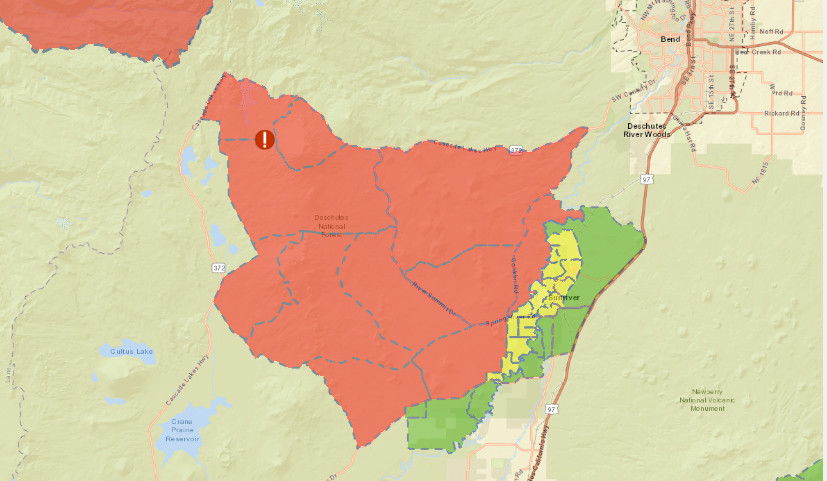
SUNRIVER, Ore. (KTVZ) -- The Little Lava Fire kept on growing and putting up a large smoke plume Tuesday as Deschutes County emergency managers once again expanded the Level 3, 2 and 1 evacuation zones to include more populated areas south of Bend -- including Sunriver raising to Level 2, "Be Set" to leave at a moment's notice.
The Deschutes County Sheriff's Office issued this evacuation update Tuesday:
September 9, 2024 / 5 PM Update
Due to continued current and expected growth to the east on the Little Lava Fire, the Deschutes County Sheriff's Office in coordination with the Sunriver Police Department and fire managers is adjusting evacuation levels.
Current Level 3 (Go Now):
- Previous areas: Areas around Mt Bachelor south to Forest Service Rd 40, west of FS Rd 41 (Conklin Rd), and south of FS Rd 4140.
- Previous areas: South of FS Rd 40, north of FS Rd 42 (South Century Drive), east of FS Rd 4032, and west of the Deschutes National Forest Boundary.
- New areas (previously Level 2): East of FS Rd 45 (River Summit Dr) to FS 41 (Conklin Rd), south of Century Drive, and north of FS Rd 4140.
- New areas (previously Level 2): South of FS 40, north of FS 42 (South Century Drive), west of FS Rd 4210, and east of FS Rd 4032.
Level 3: Means “GO” evacuate now. Leave immediately! Danger to your area is current or imminent, and you should evacuate immediately. If you choose to ignore this advisement, you must understand that emergency services may not be available to assist you further. DO NOT delay leaving to gather any belongings or make efforts to protect your home. This will be the last notice you receive.
Current Level 2 (Be Set):
- Previous areas: Including the Deschutes National Forest east of FS Rd 41 (Conklin Rd), west of the Deschutes River, north of FS Rd 40/Spring River Dr and south of Benham Falls. Excluding private property, which is Level 1 (Be Ready).
- New areas (Previously Level 1): Sunriver and areas north of Spring River Rd (FS Rd 40) such as Besson Rd area and Spring River Acres.
- New areas: East of the Deschutes National Forest boundary south of Spring River Rd (FS Rd 40) south to South Century Dr (FS Rd 42) including River Meadows, Stage Stop Meadows, and Deschutes River Recreational Homesites.
Level 2: Means “BE SET” to evacuate. You must prepare to leave at a moment’s notice. This level indicates there is significant danger to your area, and residents should either voluntary relocate to a shelter or with family and friends outside of the affected area, or if choosing to remain, to be ready to evacuate at a moment’s notice. Residents MAY have time to gather necessary items, but doing so is at their own risk. This may be the only notice you receive. Emergency services cannot guarantee that they will be able to notify you if conditions rapidly deteriorate. Area media services will be asked to broadcast periodic updates.
Current Level 1 (Be Ready):
- Previous Areas: West of the Deschutes River from Fall River Estates north to Spring River Rd, including Fall River Estates, and River Forest Acres.
- New areas: West of Hwy 97 south of Lava Butte and adjacent to Sunriver, south to Vandevert Rd including the Sunriver Business Park, Caldera Springs, Crosswater and Vandevert Ranch.
- New areas: Oregon Water Wonderlands and Big River Drive area north of South Century Dr (FS Rd 42).
Level 1: Means “BE READY“ for potential evacuation. Residents should be aware of the danger that exists in their area, monitor emergency services websites and local media outlets for information. This is the time for preparation and precautionary movements of persons with special needs, mobile property and (under certain circumstances) pets and livestock. If conditions worsen, emergency services personnel may contact you via an emergency notification system.
Public Safety Agencies are working with the Incident Management Team and the Deschutes National Forest to continually monitor the situation and adjust evacuation levels accordingly.
A shelter is being stood up at the La Pine Community Center located at 16405 1st St in La Pine.
Current maps including evacuation areas can be found at:
https://deschutes.org/emergency
For fire information, you can visit the Central Oregon Fire Information site at:
An information line will be staffed until about 9:00 PM tonight. Please only call if you need assistance or if you need clarification after reviewing online sources above. The information number is 541-550-4888.
---
"It's very nerve-wracking, you know, I mean, because everybody's going to try to get out same time," said Matthew Manly, a resident of Sunriver. "Where are you going to go? You know, some people have motor homes and trailers, and we don't."
Resident Ken Cross, "People are coming in, gassing up, getting their propane, hooking up their trailer being ready to move out here."
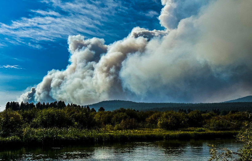
The Little Lava Lake and Backside fires are challenging firefighters and impacting Sunriver residents. They're just two of 30 blazes which make up the Bachelor Complex, mostly caught small size.
John Mozena, a frequent visitor to Sunriver, said, "We were going to be here for another week. With the Level 1 one evacuation notice, we decided that it would be best to get out of here while we can."
Stan Hinatsu, the public information officer for the Northwest Team 3, "The fire has got up and moved to the east, being pushed by a moderate - not a big one, but a much more moderate breeze from the west to the north, northwest, west wind and pushing that fire to the east."
The fire is burning only about 8-10 miles away from Sunriver. Since Monday the Lava Lake Fire doubled to more than 2,500 acres as of Tuesday, according to Northwest Team 3. The nonprofit Watch Duty said the National Interagency Fire Center, reported the toll being much higher at over 5,700 acres burned.
HInatsu said, "We're hoping to hold it, and we've got some dozer lines were established yesterday and trying to if you will stitch those lines together, the dozer lines and the road system that are in there to see if we can get a good containment line, that we can hold the fire."
When the evacuation notice was at Level 1 earlier Tuesday, it seemed to be business as usual for many folks.
"The smoke has kind of bothered us," worker Ramey Speece. We got a lot of ash on the ground and everything we're working with. But as far as the danger of it, we're not too concerned."
Another worker, Ken Martin, said, "No one's really saying much. They're just going with their normal daily activities."
But Mozena said, "It's unnerving. I think any time you're worried about your possessions, especially your own - your home is always something special to you.".
Speece added: "As long as we've worked out here, we know the potential danger of it. So it hasn't affected us too much, as far as that notice. We just - you know, it just makes us a little bit more vigilant."
The Bachelor Complex Fire is currently at 0% containment. Central Oregon Fire Management is hopefully though with expected rain, cooling temperatures and lower winds, they'll be able to get better control of this fire.
The Pacific NW 3 Complex Incident Management Team took command of the Bachelor Complex Tuesday morning.
Here's their Tuesday afternoon update:
Bachelor Complex and
Flat Top and Firestone Fires Update
September 10, 2024
Northwest 3 Complex Incident Management Team assumed command of fires on the Deschutes National Forest today. The team is developing strategic plans while continuing ongoing fire suppression operations for the Bachelor Complex Fires, the Firestone Fire and the Flat Top Fire. There are Level 1, 2 and 3 evacuation notices in or near fire areas, and Forest area closures orders are in effect.
Aircraft dropped water to moderate fire spread on Monday and flew reconnaissance missions to aid in planning. More firefighting resources are expected to arrive today.
Bachelor Complex: The Bachelor Complex is a group of about 30 fires that range from one-tenth of an acre to over 1,000 acres. The Little Lava Fire, about two miles southeast of Little Lava Lake, was very active on Monday, moving to the east, and grew to approximately 2,500 acres. Firefighters constructed dozer line in strategic locations to slow fire spread.
The 85-acre Backside Fire has line around all edges and crews are mopping up by cooling interior hot spots. Firefighters are working to improve indirect control lines along the Forest Service Road 4525 and Forest Service Road 45 on the southeast corner of the Batchelor Complex to minimize potential spread of the Little Lava Fire. Fire suppression efforts are ongoing for other fires in the complex.
Flat Top Fire: Winds from the north and northwest increased fire behavior on the Flat Top Fire on Monday, and the fire grew on all edges fed by seasonally dry vegetation. The fire is currently estimated at 14,400 acres. On the southeast end of the Flat Fire, the Cabin Lake Guard Station remains secure.
Firestone Fire: The Firestone Fire also actively burned on Monday, with wind increasing fire behavior at all edges and growth in the northeast corner. It is approximately 6,800 acres. Firefighters are working to connect roads for both the Flat Top and Firestone Fires to be used as direct and indirect containment lines.
Weather and Fire Behavior: Overnight humidity recoveries will help to delay the start of the burn period today, but firefighters expect very active fire by early afternoon and into the evening. Today should be hot and dry over all fire areas. Vegetation is seasonally dry and will support rapid fire spread and intensity even under moderate weather conditions or low wind speeds.
Evacuations: Emergency management and fire officials are coordinating closely and adjusting evacuation levels as needed. Level 3 evacuations mean “Go Now,” Level 2 means “Be Set,” and Level 1 means "Be Ready.” To view current evacuation levels, please visit the Deschutes County Emergency Information Interactive Map at: http://www.deschutes.org/emergency. For Lake County evacuation information, please visit: https://www.lakecountyor.org/flat_top.php
CLOSURES: There are two closure areas on the Deschutes National Forest for these fires. View the orders on the Deschutes National Forest site at: https://www.fs.usda.gov/alerts/deschutes/alerts-notices .
Facebook: https://www.facebook.com/deschutesnationalforest/
Fire Information Line: 541-249-9829, 8:00 a.m. to 8:00 p.m.
--
Earlier, in a video posted to the Deschutes National Forest Facebook page, team Operations Chief Nathan Goodrich noted the significant fire growth seen on the large fires burning in the region Monday and more growth expected Tuesday before a cool, wet weather system moves in from the north starting Wednesday and gives fire crews an assist.
Matthew Draxton is in Sunriver Tuesday, talking to residents, visitors and businesses about the rare pre-evacuation notice for the busy resort. His report will be on NewsChannel 21 Fox at Four (other evening newscasts are pre-empted by the presidential debate.)
Here's the Deschutes County Sheriff's Office Little Lava Fire update Monday evening:
Due to significant growth of the Little Lava Fire to the east, the Deschutes County Sheriff's Office in coordination with fire managers is expanding the evacuation areas.
Current Level 3 (Go Now):
- Previous evacuation areas around Mt Bachelor south to to Forest Service Rd 40, west of FS Rd 41 (Conklin Rd), and south of FS Rd 4140.
- Areas south of FS Rd 40, north of FS Rd 42 (South Century Drive), east of FS Rd 4032, and west of the Deschutes National Forest Boundary.
Level 3: Means “GO” evacuate now. Leave immediately! Danger to your area is current or imminent, and you should evacuate immediately. If you choose to ignore this advisement, you must understand that emergency services may not be available to assist you further. DO NOT delay leaving to gather any belongings or make efforts to protect your home. This will be the last notice you receive.
Current Level 2 (Be Set):
- Areas south of FS 40, north of FS 42 (South Century Drive), west of FS Rd 4210, and east of FS Rd 4032.
- Areas east of FS Rd 45 (River Summit Dr) to FS 41 (Conklin Rd), south of Century Drive, and north of FS Rd 4140.
- Deschutes National Forest east of FS Rd 41 (Conklin Rd),west of the Deschutes River, north of FS Rd 40/Spring River Dr and south of Benham Falls. Excluding private property, which is Level 1 (Be Ready).
Level 2: Means “BE SET” to evacuate. You must prepare to leave at a moment’s notice. This level indicates there is significant danger to your area, and residents should either voluntary relocate to a shelter or with family and friends outside of the affected area, or if choosing to remain, to be ready to evacuate at a moment’s notice. Residents MAY have time to gather necessary items, but doing so is at their own risk. This may be the only notice you receive. Emergency services cannot guarantee that they will be able to notify you if conditions rapidly deteriorate. Area media services will be asked to broadcast periodic updates.
Current Level 1 (Be Ready):
- Areas west of the Deschutes River from Fall River Estates north to Spring River Rd, including Fall River Estates, River Forest Acres, River Meadows, Stage Stop Meadows, and Deschutes River Recreational Homesites.
- Areas north of Spring River Rd west of the Deschutes River including Besson Rd area and Spring River Acres.
- Sunriver
Level 1: Means “BE READY“ for potential evacuation. Residents should be aware of the danger that exists in their area, monitor emergency services websites and local media outlets for information. This is the time for preparation and precautionary movements of persons with special needs, mobile property and (under certain circumstances) pets and livestock. If conditions worsen, emergency services personnel may contact you via an emergency notification system.
Current maps including evacuation areas can be found at:
https://deschutes.org/emergency
For fire information, you can visit the Central Oregon Fire Information site at:
--
