Little Lava Fire lines hold, Bachelor Complex 50% contained; FS Road 40 reopening; emergency closure area reduced
Update: Emergency closure area reduced)
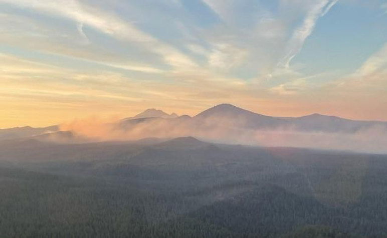
BEND, Ore. (KTVZ) -- Crews were pulled off the Little Lava Fire on Wednesday before a windy cold front moved through, bringing safety risks, more smoke and 40 mph wind gusts that downed trees, but little growth was seen, officials said Thursday. With containment at 50%, Forest Service Road 40 reopened and the temporary emergency closure area was reduced.
Bachelor Complex Fire Update
September 26, 2024
Quick Facts: Bachelor Complex
Size: 11,742 acres Start Date: September 8, 2024 Location: 20 miles SW Bend, OR
Personnel: 140 Containment: 50%
Forest Service Road (FSR) 40 will be reopened to the public today at 5:00pm. The FSR 45 closure points will be at the FSR 45 and FSR 40 junction and the FSR 45 and Cascade Lakes Highway junction.
This will be the last written daily update for the Bachelor Complex Incident. Future updates will be produced intermittently as needed. Information of significance on the Bachelor Complex fires will continue to be shared on the Deschutes National Forest Facebook page, Central Oregon Fire Information X/Twitter, Central Oregon Fire Information website, and InciWeb.

Bachelor Complex:
Yesterday, a cold front moved through the fire area with sustained winds of 10 to 20 mph and gusts between 25 to 40 mph out of the southwest. This brought increased smoke from the Bachelor Complex into the surrounding areas. The front seemed to have very little effect on the Little Lava Fire with minimal growth observed on the uncontrolled northern edge. Only a small amount of rain was reported on the far western edge of the fire.
With the high winds yesterday bringing significant risk to firefighter safety, resources were pulled off the line at 11:00am. Prior to the wind event, aviation resources were used to assist firefighters in controlling pockets of interior heat adjacent to the line in the southwest corner of the Little Lava Fire. Around 1:00pm the wind shifted direction and there were reports of trees coming down in the interior of the fire due to the strong winds.
Today, mop-up efforts will continue on the southern edge of the fire and firefighters will start to prepare FSRs 4525 and 4529 in the southwestern area of the fire as containment features. Firefighters will monitor and patrol the lines in the northeast area of the fire as the objectives in that area have been met. Suppression repair efforts on the east side of the fire will begin in the next couple of days.
Weather and Fire Behavior:
Mild and dry conditions will prevail over the fire area today, with temperatures in the 60s-70s. Light terrain driven wind will shift to a light west wind in the afternoon. Mild and dry conditions will persist through the weekend.
To view the closure order and map, visit: https://www.fs.usda.gov/alerts/deschutes/alerts-notices.
InciWeb: https://inciweb.wildfire.gov/.../ordef-bachelor-complex...
YouTube: https://www.youtube.com/@CentralOregonFireInfo?app=desktop
Fire Information Line: (541) 249-9829, 8:00 a.m. to 8:00 p.m.
Smoke & Air Quality Information: fire.airnow.gov
--
Temporary Emergency Fire Closure for Bachelor Complex Reduces in Size
Closures remain in place for public and firefighter safety
Effective immediately, the Deschutes National Forest has updated and decreased the temporary emergency fire closure area on the Bend-Fort Rock Ranger District for the Bachelor Complex due to increased containment, decreased fire activity and moderating weather conditions.
The updated emergency closure order for the Bachelor Complex of fires includes the following closed locations. Please see closure order map.
The following developed and dispersed recreation sites are temporarily closed:
- AC/DC Shelter
- Corral Swamp Trailhead
- Edison Shelter
- Edison SnoPark
- Kapka Butte SnoPark
- Kwohl Shelter
- Lucky Lake Trailhead
- Sheridan Shelter
- Six Lakes Trailhead
- Wake Butte Trailhead
Roads in the area:
- All National Forest System Roads found within the area closure are closed. Cascade Lakes Highway (NFSR 46) and NFSR 40 will remain open for public use.
The Metolius-Windigo Trail between Quinn Meadow and Todd Creek remains closed.
For information regarding temporary emergency closures on the Deschutes National Forest visit fs.usda.gov/alerts/deschutes/alerts-notices.
Willamette Complex North Update
Boulder Creek, Ore, Linton Creek, 374 and Pyramid Fires
Fire Update for Thursday, September 26 through Friday, September 27, 2024
Fire updates will be provided for a two-day operational period.
InciWeb: https://inciweb.wildfire.gov/incident-information/orwif-north-willamette-complex
Willamette Complex North Facebook Page: https://www.facebook.com/profile.php?id=61565845313387
Email:2024.WillametteComplex.North@firenet.gov
Information line: 541-208-1262 Hours: 8 a.m. to 8 p.m.
Overview: The fire areas are experiencing cooler temperatures and an increase in humidity, forecasted for the next few days. Crews were limited in their work Wednesday as .10 to .75 inches of rain fell in the fire areas, bringing with it gusting winds with the potential to bring down fire-weakened trees. Thursday, firefighters are continuing suppression repair work. Fuel moistures will continue to limit fire activity. Little to no fire growth is anticipated within the North Complex over the next few days. Willamette National Forest has rescinded fire restrictions and campfires are once again allowed outside of developed campgrounds and restrictions on chainsaws, off-highway vehicles, and smoking have been lifted. It is still critical to completely extinguish campfires until they are cold to the touch, even with the reduced fire risk.
Boulder Creek: 523 acres, 51% contained
Located 5 miles east of McKenzie Bridge. Fire behavior was minimal yesterday, but firefighters are still locating and addressing hotspots. Mastication has been completed and firefighters will continue to mop up containment lines and fire suppression repair work. Crews are pulling hose and removing excess equipment.
Ore: 3,484 acres, 80% contained
Located 7 miles northeast of Blue River. Ore Fire received about ½” of rain yesterday. Crews are engaged in suppression repair work. Fire activity has remained low.
374: 62 acres, 0% contained and Linton Creek: 1,309 acres, 0% contained
Located in the Three Sisters Wilderness. These fires received rain yesterday and fire activity has remained minimal. Despite the warm weather on Tuesday, these fires have remained in their footprints adjacent to natural barriers and previous fire scars. Both fires will continue to be in a monitoring status, with no additional action needed at this time.
Pyramid: 1,312 Acres, 100% contained
East of Middle Santiam Wilderness. This fire received about ¾” of rain yesterday and remains fully contained with minimal fire behavior and scattered areas of heat in the interior of the fire area. Firefighters are continuing with suppression repairs. Tomorrow, Northern Rockies Incident Management Team 6 will be transitioning this fire back to Willamette National Forest and Type 4 organization.
Willamette National Forest Area Closures: Forest officials are continually evaluating closure orders and will adjust as conditions allow. Fire-related closures remain in place on the McKenzie River Ranger District, as well as on the Middle Fork Ranger District in the immediate fire operations area for public and firefighter safety. Please respect and avoid all closed areas of the national forest.
Source: https://www.fs.usda.gov/detail/willamette/fire/?cid=fseprd552029.
Road Closures: OR-242 remains closed to all traffic between the intersection with OR-126 and the Dee Wright Observatory (mileposts 55 to 75). For current road conditions, please check Oregon Department of Transportation’s website: https://www.tripcheck.com/.
Related Links:
--
Willamette Complex South & Red Fire Update
Red, 208, Moss Mountain, Coffee Pot, Tire Mountain, McKinley Creek and Chalk Fires
Date: Thursday, September 26, 2024 Fire Causes: Lightning
Email: 2024.willamettecomplex@firenet.govInformation Phone Line: 541-208-1742
Willamette Complex South: Total Personnel:495| Total Willamette Complex South Acres: 23,480
InciWeb: https://inciweb.wildfire.gov/incident-information/orwif-willamette-complex-fires-south
Facebook: https://www.facebook.com/WillametteComplexFires/
Red Fire: Total Personnel: 77 | Total Red Fire Acres: 1,916
InciWeb: https://inciweb.wildfire.gov/incident-information/ordef-red-fire
Facebook: https://www.facebook.com/2024RedFireOR/
Summary
Personnel and equipment have shifted around the complex recently as conditions have continued to change. Over the last two days, firefighters focused on monitoring and suppression efforts, given the warmer, drier weather. The cold front that passed through the region yesterday brought cooler, moister weather, including light afternoon showers over much of the region. With that change, primary efforts have reverted to repairing forest roads and finalizing removal of woody debris from indirect firelines. Monitoring, road rehabilitation, and suppression repair continue on the Chalk, Coffee Pot, McKinley Creek and Tire Mountain fires, all still 100% contained. Road repair crews throughout the complex are emphasizing ditch and culvert clearing prior to final grading of the road surfaces. Some workers assigned to the Chalk and Coffee Pot fires may shift to the Roads Group for more efficient use of personnel. Overall, the Incident Management Team has focused recently on decreasing staff numbers to “right-size” operations.
Red Fire (1,916 acres, 11% containment)
Fire acreage grew 85 acres in the past two days because of warmer, drier weather. Firefighters anticipated this growth as the fire continues to slowly move down-slope toward Crescent Lake. Monitoring of fire activity remains a priority, particularly in the Whitefish Creek drainage and along Forest Service Road 60. A drone will aid in monitoring fire activity today.
208 Fire (9,045 acres, 4% containment)
Chipping operations continue on indirect lines surrounding the fire as crews near completion of this work. Firefighters continue frequent monitoring of the recently active northwest corner of the fire in the Swift Creek area.
Moss Mountain Fire (2,186 acres, 10% containment)
Fuel reduction around the Wolf Mountain Communications site paused yesterday because of stormy weather, and firefighters shifted to road repair work in safer locations. With milder weather expected, they will resume work around the communications infrastructure for the next few days. Road repair crews will soon put the finishing touches on the 23 Road. A drone may assist with monitoring of fire activity today.
Weather and Fire Behavior
Precipitation yesterday was more widespread than anticipated, but the most rain recorded on the complex amounted to only two-tenths of an inch. With the passage of the front, milder fall-like conditions resume. Clouds will linger this morning with a 5% chance of additional precipitation. High pressure settling in today should usher in clear skies with highs in the upper 60s to low 70s and lower relative humidity.
Closures, Fire Restrictions, and Evacuation
- For closure information, visit: https://tinyurl.com/RedFireClosures2024 & https://tinyurl.com/WillFireClosures2024.
- For fire restrictions, visit: https://tinyurl.com/DesFireRestrictions2024 & https://tinyurl.com/WillFireRestrictions2024.
- The Level 1 – BE READY to Evacuate notice remains in effect for the Red Fire. For more information or to sign up for alerts, visit: www.klamathcounty.org/300/emergency-management.
Public Information
Willamette Complex – South
Eastern Area Complex Incident Management Team
Public Information Line: 541-208-1742, 8 a.m. – 8 p.m.
