Little Lava Fire holds at 11,225 acres; Bachelor Complex 50% contained; Red Fire near Crescent Lake tops 2,000 acres
BEND, Ore. (KTVZ) – The Bachelor Complex, including the Little Lava Fire, held at 50% containment this weekend, with no change in acreage reported, while the Red Fire near Crescent Lake has grown to over 2,000 acres but still 11% contained officials said Sunday.
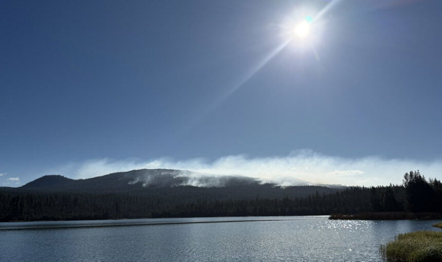
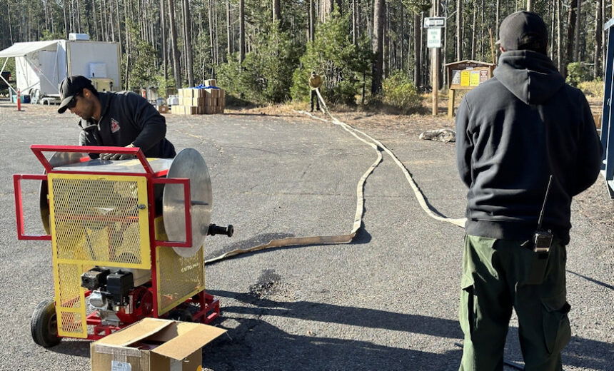
The complex consists of about 30 fires sparked by lightning Sept. 6, most kept small. The Little Lava Fire is holding at 11,225 acres. While no more full daily updates are planned, Central Oregon fire officials released photos of the fire still putting up smoke in a view from Lava Lake Campground and firefighters backhauling hose that’s no longer needed.
Find more of the latest info at: https://inciweb.wildfire.gov/incident-information/ordef-bachelor-complex-fires.
Here are Sunday's other fire updates in the area:
--
Willamette Complex South & Red Fire Update
Red, 208, Moss Mountain, Coffee Pot, Tire Mountain, McKinley Creek and Chalk Fires
Date: Sunday, September 29, 2024 Fire Causes: Lightning Email: 2024.willamettecomplex@firenet.gov Information Phone Line: 541-208-1742
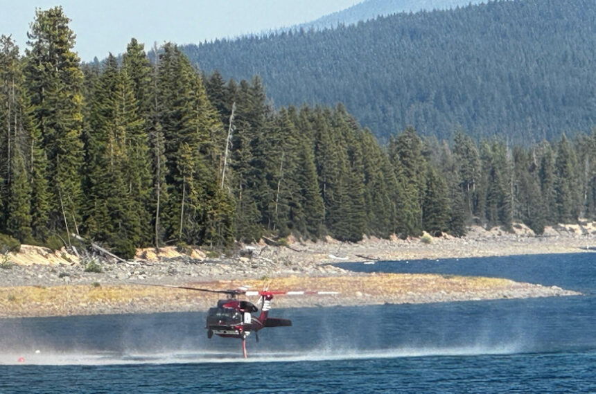
Willamette Complex South: Total Personnel: 471| Total Willamette Complex South Acres: 23,594 InciWeb: https://inciweb.wildfire.gov/incident-information/orwif-willamette-complex-fires-south Facebook: https://www.facebook.com/WillametteComplexFires/
Red Fire: Total Personnel: 68 | Total Red Fire Acres: 2,069 InciWeb: https://inciweb.wildfire.gov/incident-information/ordef-red-fire Facebook: https://www.facebook.com/2024RedFireOR/
Summary
The reallocation and repositioning of resources to maximize impact and efficiency on these fires is netting positive results. Though there have been slight increases in smoldering acreage, the fires remain well within established containment perimeters. Firefighters continue their focus on monitoring and suppression efforts. The forecast for the beginning of the week calls for a slight rebound of humidity levels before they trend down late Sunday into Monday. Crews continue repairing McKinley Creek dozer lines and clearing ditches in the Coffee Pot area. Repair work along the 2129 Road is ongoing. The Chalk, Coffee Pot, McKinley Creek and Tire Mountain fires are 100% contained. Any hot spots are well inside the perimeter, and the seeding of the Red Fire shaded fuel breaks is complete.
Red Fire (2,069 acres, 11% containment)
The Red Fire, which continues to creep slowly toward Crescent Lake, will remain on the landscape and won’t be completely extinguished until a season-ending event. The assessment of 11% containment of the Red Fire is based on cold sections of the fireline running north on the Pacific Crest Trail. As the fire moves to the south toward Crescent Lake and meets the shaded fuel break built along Forest Service Road 60, this percentage will increase. Percentage of fire contained is based on how much of the current fire perimeter has a directly positioned control-line that is stopping fire spread. This number — a percentage of the total fire perimeter — may fluctuate as the fire grows and an additional surrounding control line is secured.
The strategic firing operations tentatively planned for yesterday along the shaded fuel break were paused as wind shift resulted in unfavorable conditions. The intent is to clean up potential fuels ahead of the active fire where the fire’s edge will meet the fuel break and intersect FSR 60. As they have done for weeks, fire managers continue to update and review that plan regularly to ensure firefighter safety while protecting the community and critical resources.
An emergency fire closure remains in place for the Red Fire. Fire managers and Deschutes National Forest leadership are continually reevaluating the closure based on factors such as current and expected fire behavior and weather conditions. The Deschutes National Forest will reduce the closure as soon as it is safe to do so.
NOTE: This will be the last daily written update for the Red Fire. The Eastern Area Team will transition the Red Fire back to the Deschutes National Forest at 6pm today, September 29. There will also no longer be a dedicated incident email or Public Information phone line for the Red Fire. Significant fire updates will continue to be posted on the Red Fire Facebook page and Inciweb. Written updates will be prodcued as needed.
208 Fire (9,045 acres, 4% containment)
Chipping operations and mop-up continues on indirect lines surrounding the fire as crews near completion of this work. Much of that is happening on the west side near the Sierra Pacific Industries timberland and along the 2149 Road. Firefighters also continue frequent monitoring of the northwest corner of the fire in the Swift Creek area, and erosion prevention water bars are being constructed along the 6010 Road.
Moss Mountain Fire (2,186 acres, 10% containment)
Fuel reduction operations near the Wolf Mountain Communications site are nearing completion. Heavy equipment continues working in that critical area. The 23 Road remains closed to accommodate the removal of slash and brush. Air operations will be conducted as necessary. The weather forecast means favorable flight conditions for the next several days.
Weather and Fire Behavior
Mild, fall-like conditions will continue for the next several days. Temperatures are predicted to reach the upper-60s to low-70s. The air will give way to increasingly dry air by Sunday evening, and the relative humidity will likely drop to 20% or less in the early part of next week. This lower relative humidity could result in a change in fire behavior.
Closures, Fire Restrictions, and Evacuation
For closure information, visit: https://tinyurl.com/RedFireClosures2024 https://tinyurl.com/WillFireClosures2024.
For fire restrictions, visit: https://tinyurl.com/DesFireRestrictions2024 https://tinyurl.com/WillFireRestrictions2024.
The Level 1 – BE READY to Evacuate notice remains in effect for the Red Fire. For more information or to sign up for alerts, visit: www.klamathcounty.org/300/emergency-management.
Public Information
Willamette Complex – South
Eastern Area Complex Incident Management Team
Public Information Line: 541-208-1742, 8 a.m. – 8 p.m.
--
Rail Ridge and Wiley Flat Fire Update
September 29, 2024
Central Oregon Wildfire Information: centraloregonfire.org
Email: 2024.railridge@firenet.gov – Phone: 541-208-7111
Social Media, Evacuation and Closure Information: https://linktr.ee/RailRidgeFire
Rail Ridge Fire
Acres: 165,586 – Containment: 80% – Detection Date: 09/02/24 – Cause: Lightning – Total resources: 1,136
Operational Update: Yesterday, hot and dry conditions contributed to an increase in acreage on the Rail Ridge Fire. In the Black Canyon Wilderness, the fire crossed Black Canyon Creek onto the ridge east of Honeymoon Basin and poses new challenges to firefighters. Today’s weather will be much cooler, though winds will be stronger and out of the northwest, and relative humidity will be lower. Weather continues to challenge efforts. In the northern divisions, firefighters continue to mop up and extinguish isolated heat sources and are working toward suppression repair. More fireline has been added to containment. In the southern portion of the fire, patrols continue, and suppression repair is ongoing. Much of the repairs are being made to roads which received heavy impacts during suppression efforts.
Wiley Flat Fire
Acres: 30,186 – Containment: 94% – Detection Date: 09/02/24 – Cause: Lightning – Total resources: 47
Operational Update: Heavy equipment made progress on road repairs and falling teams are taking out hazard trees along road corridors.
Weather
Tomorrow’s wind direction will change and come from the northwest. It will be a dry day as relative humidity is expected in the teens. Temperatures will be much cooler, with highs only reaching into the sixties.
Evacuations
Rail Ridge Evacuations: Level 1 and 2 evacuation zones for the Rail Ridge Fire remain in Grant County.
Wiley Flat Evacuations: Level 2 and 3 evacuation zones are in place for the Wiley Flat Fire in Crook County.
For Current Evacuation Levels in Wheeler, Crook and Grant counties, please visit: https://linktr.ee/RailRidgeFire
Closures
The U.S. Forest Service and Bureau of Land Management have implemented closures for the Rail Ridge and Wiley Flat Fires. For more details and closure maps, visit https://linktr.ee/RailRidgeFire
