C. Oregon’s bout of ‘unhealthy’ smoke continues; Death Cab for Cutie concert canceled

(More unhealthy readings; concert cancellation)
Brandi Carlile's 2nd concert reset for Sept. 20; Oregon DEQ expands air quality alert to Crook, other counties
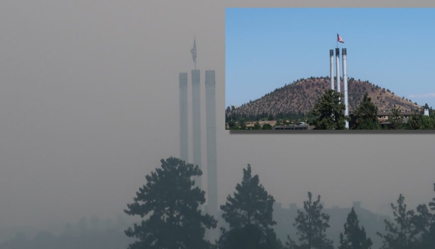
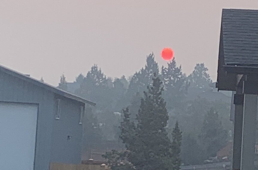
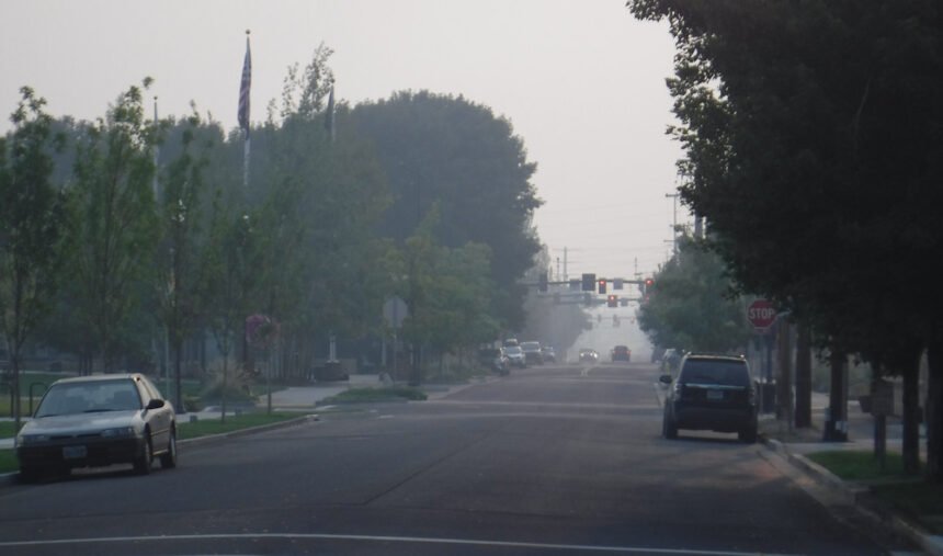
BEND, Ore. (KTVZ) – Another day of thick, "hazardous"-level wildfire smoke was keeping many Central Oregonians indoors on Labor Day and prompted cancellation of another Les Schwab Amphitheater concert.
The venue said Monday night's concert by Death Cab for Cutie was canceled due to the unhealthy air quality. Refunds are available at the point of purchase.
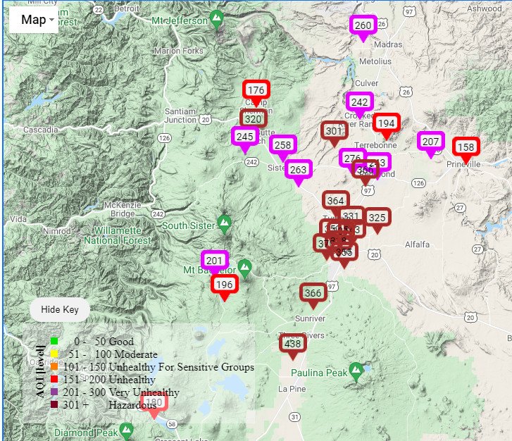
On Sunday, the smoke from wildfires burning around the region prompted an expanded air quality advisory to include all of Central Oregon. While the advisory is at this point due to end Tuesday, the smoke and haze are now forecast to last several more days.
On Sunday, the concert venue called off and rescheduled Sunday night's Brandi Carlile concert due to the smoke.
The Les Schwab Amphitheater posted to Facebook that Sunday night's concert, the second of Carlile's two shows in Bend this weekend, had been postponed and rescheduled for Monday, Sept. 20. Refunds are available at point of purchase, the venue said, adding, "Thank you for your patience and understanding."
Deschutes and Jefferson counties already were under an Oregon Department of Environmental Quality air quality advisory through 5 p.m. Tuesday, but that was expanded Sunday to include Crook, Wheeler and Grant counties.
“Wildfires burning in the region, combined with forecasted conditions, will cause air quality to reach unhealthy levels,” the National Weather Service advised, as the Bend-area forecast showed the potential for hazy skies through Wednesday night.
Since the smoke can cause burning eyes a runny nose and aggravate heart and lung diseases and aggravate other health issues, people were urged to “limit outdoor activities and keep children indoors if it is smoky.”
The Bend area had “hazardous” air quality readings Sunday morning and other areas were “very unhealthy,” according to the E::Space Labs map on KTVZ.COM’s weather page, though most dropped to the “very unhealthy” or “unhealthy” levels by mid-afternoon -- and were back at "unhealthy" air quality Sunday nigh and on Monday.
A new wildfire that broke out southeast of La Pine Saturday afternoon was lined at 45 acres, though mop-up work continues.
Here's a look at Sunday's update on some of the other major fires still burning in the region as we approach the one-year mark after Oregon's devastating 2020 wildfires:
Middle Fork Complex Daily Update – September 5, 2021
Northwest Incident Management Team 6
Shawn Sheldon, Incident Commander
Phone: 425-324-1267 (8am – 8pm)
Email: 2021.middlefork@firenet.gov
InciWeb: inciweb.nwcg.gov/incident/7745
Facebook: facebook.com/MiddleForkComplex
Twitter: twitter.com/willametteNF
Origin/Location: North of Oakridge, OR
Gales: 22,167 acres and 13% contained Date/Time Detected: July 29, 2021, 2:00 p.m.
Kwis: 1,485 acres and 98% contained Number of Personnel: 703
Total: 23,739 and 20% contained Cause: Lightning
Westfir, OR – Growth on the Gales Fire continues to be steady, and crews on the northwest flank of the fire have successfully connected firing operations between the eastern flank and the northern side of the fire. Mop up will continue in this area to increase confidence in the line holding.
Several active fingers and spot fires in the southern drainages of the fire are high priorities for operations today. The Portland Creek spot and finger growth in Nevergo Creek are near strategically-burned control line to the west, so an additional half-mile of strategic burning was added yesterday to strengthen this area. Additional strategic burning will occur today to tie in this new growth and prevent further uphill spread. Spot fires in Delp Creek and Purdue Creek are showing less activity, and line construction around them continues.
The Kwis Fire continues to put out interior heat, but as containment strengthens, confidence rises that the fire will stay within its current footprint. One engine is assigned to patrol and mop up the containment line up to 300 feet inward.
Weather: The past two days have been hot, dry, and favorable for an increase in fire behavior and potential spread, yet the fire grew only minimally. Drought-stressed fuels continue to be of concern. Slightly higher humidities today coupled with increasingly warmer temperatures the next several days are expected to yield similar fire behavior to the past several days.
Closures: Closures areas for the Middle Fork Complex are issued by the Willamette National Forest. See https://www.fs.usda.gov/alerts/willamette/alerts-notices for more information on these closures. Closures on major roads include Salmon Creek, Big Fall Creek, and Aufderheide Roads.
Safety: As fire personnel are moving to and from their base camp daily, please be aware of increased traffic. Following at a safe distance at a safe speed and keeping away from fire closures are a few ways to support firefighting efforts.
Bull Complex Factsheet for September 5
Bull Complex Wildfire
News – 6 hrs. ago
Inciweb: https://inciweb.nwcg.gov/incident/7773/
Email: 2021.bull@firenet.gov
Phone: 971-277-5075
Facebook: https://www.facebook.com/mthoodnf https://www.facebook.com/willamettenf
Twitter: https://twitter.com/mthoodnf https://twitter.com/willamettenf
Cause: Lightning Size: 15,804 acres Containment: 7 percent
Personnel: 570
Incident Command: Type 2 Northern Rockies Incident Management Team 4, Rick Connell, Incident Commander
Current Status: As the smoke cleared out, fire activity did increase in several locations and pushed smoke in a northeasterly direction throughout the day. The fire remained active in the Mother Lode and Welcome Creek drainages and helicopter bucket water drops were used to slow fire spread in several key locations including as it approached the Bull of the Woods Lookout.
Fire crews along the south side tested hose lines and pumps and monitored fire activity on the ridge between Battle Creek and Elk Lake Creek. Firefighters on the southeast side conducted some small tactical burning operations to slow and hold up the fire near the 4696 road and patrolled the existing containment lines. Additional tactical burning operations built more depth along the eastern side of the fire and from Rhododendron Ridge.
Adjusting to the wind shift, crews worked to mop up and secure the eastern line and utilized an Unmanned Aircraft System (UAS) with infrared heat sensors to seek out and extinguish pockets of heat working off the 6350 road to hold the line. Crews patrolled the containment lines on the northeast side of the fire at the confluence of the Collawash River and Elk Lake Creek. Material was hauled from the indirect lines that have been prepared north and northwest of the fire area.
Planned Actions: Firefighters will mop up along the eastern side of the fire and hold the line where recent burning has been completed to secure the edge. Crews will test hose lines and pumps on the indirect lines along the southern side and monitor the fire activity.
Along the southeastern and northeastern corners, where containment lines have been established, firefighters will strengthen those containment lines and mop up hot spots. Helicopters will continue to be used to slow fire spread in key areas on the northwest side of the fire and in other areas as necessary. The fire is expected to be active again when the smoke layers lift.
Large amounts of smoke are expected during the day because the vegetation and fuels are very dry and release a lot of smoke as they burn.
The weather today will be similar as yesterday, with temperatures from the mid 70s to lower 80 degrees, humidity levels will be in the 30% range, and winds will be out of the west/ southwest from 4-9 mph with gusts up to 14 mph. Warmer and dryer conditions are forecasted to continue through Tuesday before a change is forecasted for cooler and cloudier weather.
Evacuations: The Marion County Sheriff has issued a Level 1 “Be Ready” evacuation advisory only for Breitenbush Hot Springs. Residents should be aware of the danger that exists in their area, monitor emergency services websites and local media, and make an action plan should the evacuation level rise. The advisory can be viewed at: https://www.flashalert.net/id/MarionSheriff?alert=1.
Closures: For the safety of wildland firefighters and the public, the National Forests have enacted area closures that prevent the public from being upon National Forest System lands in the vicinity of the Bull Complex where uncontrolled fire and fire suppression activities are occurring. All Forest lands that are south and west of Forest Road 46, and east of the Riverside Fire perimeter are closed. The entire length of Forest Road 46 is closed. Lands within the 2020 Lionshead and Beachie Creek Fire areas are also closed. See the closure orders and maps at https://inciweb.nwcg.gov/incident/closures/7773/.
Contractors approved by the Forest Service through a permit system are allowed through the closure order, as are vendors and others working on recovery efforts related to the 2020 area fires. If the fire continues to grow to the south, some operations may be put on hold.
Air Quality: For information on air quality and related health concerns, visit https://fire.airnow.gov/ or https://oregonsmoke.blogspot.com/.
Primary and Cooperating Agencies: U.S. Forest Service, Oregon Department of Forestry, Bureau of Land Management, Marion County Sheriff’s Office, Clackamas County Sheriff’s Office.
