Crazy Creek Fire grows to about 28,000 acres, as visiting management team deals with more extreme fire behavior
(Update: Tuesday fire update, adding video, comments from SW Area Incident Management Team #5)
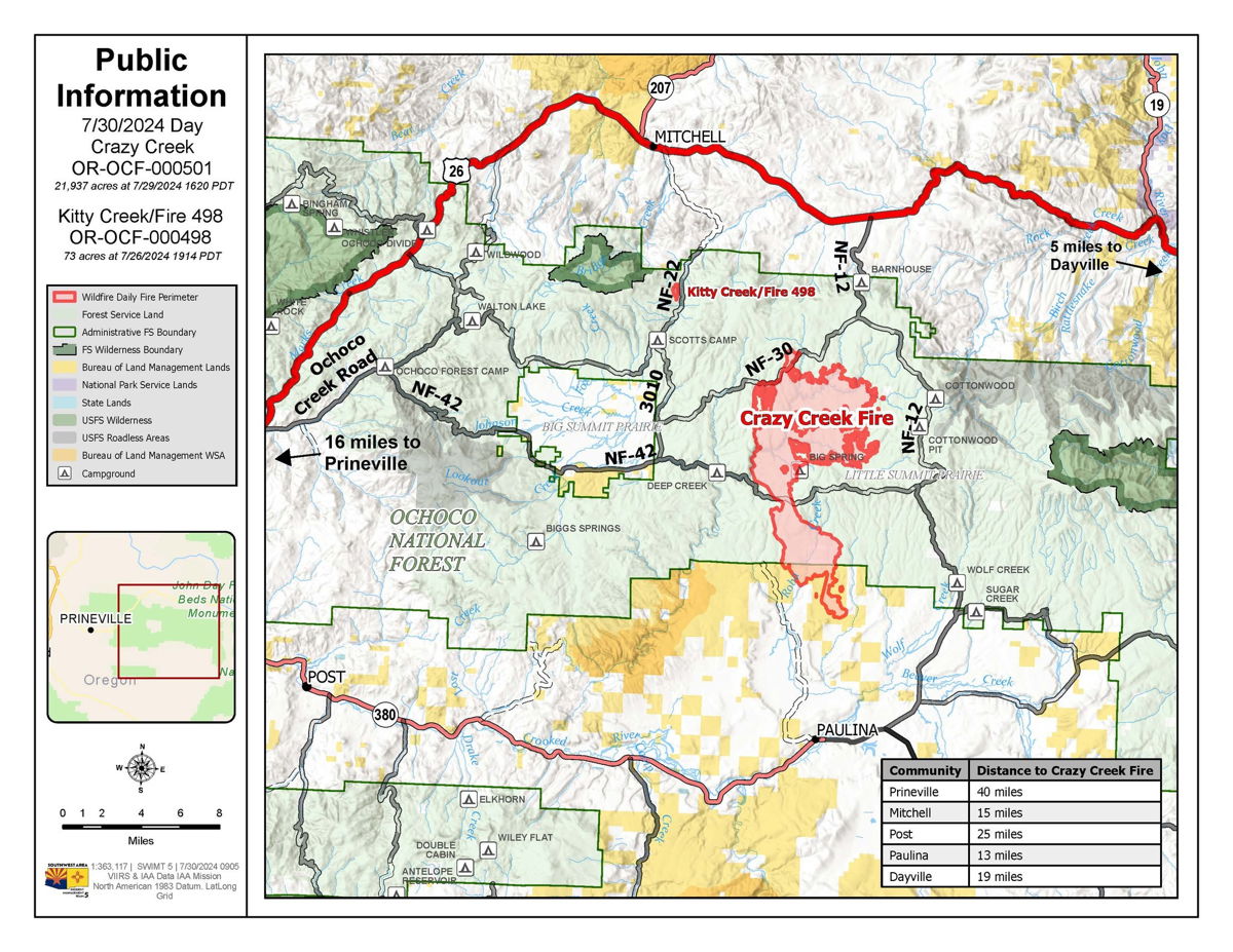
BEND, Ore. (KTVZ) -- Some new out-of-state help has arrived to help lead the fight against two fires burning in the Ochoco National Forest. The Crazy Creek fire north of Paulina has grown to more than 22,000 acres, with no containment. The Kitty Creek Fire is at 73 acres and 86% contained.
Watch Duty, quoting the National Interagency Fire Center, said late Tuesday the fire had grown to 28,064 acres.
A team based in Arizona and New Mexico, the Southwest Area Incident Management Team #5 is working with the Oregon Department of Forestry, BLM and the Forest Service.
"Crazy Creek, the fire's been moving in," Tony James of the incident management team said Tuesday. "The old-growth timber, the lot of the mixed conifer, it crawls up the the moss that's on the side of the trees. It crawls up that, spots and then that's how the fire's been progressing."
The Crazy Creek Fire is burning 40 miles from Prineville and has unique challenges.
PIO Lynn McAloon said the challenging factors include "really receptive fuels, dry, windy conditions, you know, sharing resources, being in a high level of preparedness nationally means that resources are stretched thin"
More than 300 people are working to stop the two fires. Their equipment includes 21 engines, five bulldozers and six water tenders.
There will be two in-person public meetings to discuss fire behavior, weather show fire perimeters, along with potential growth.
The first one will be 6 p.m. Wednesday at the Post General Store, 28550 SE Paulina Highway. The second will be at 6 p.m. Thursday at Crook County High School in Prineville.
McAloon said, "I'd like to remind people to stay vigilant and remember to follow any evacuation orders or advisories by local authorities such as the Crook County Sheriff's Office."
Level 3 GO NOW evacuation orders in the Ochoco National Forest have been expanded to the eastern boundary of Big Summit Prairie and south of the forest boundary. Crook County has extended level 3 go now evacuations south.
ODF and the Forest Service responded quickly to the Kitty Creek Fire, stopping it at 73 acres. Crews will now continue to monitor it for flare-ups.
James said, "We are thankful for the support that the communities have been giving us, and we look forward to continuing to work to get this fire contained and controlled."
For additional resources, you can visit Inciweb. Also, the incident management team has a Facebook page, containing operational updates.
Here is Tuesday's fire update:
--
498/Kitty Creek containment increases as national resource limitations and extreme fire behavior continue to challenge firefighters on the Crazy Creek fire
Daily Update July 30, 2024
Fire Information Phone:541-208-1768 (8am-8pm)
Media Information Phone:541-208-1770 (8am-8pm)
Email: 2024.crazycreek@firenet.gov
Acres: Crazy Creek - 21,937; 498/Kitty Creek - 73 Start Date: July 22, 2024
Location: Crazy Creek:16 miles north of Paulina, OR Personnel: 302 total for both fires
498/Kitty Creek: 7 miles south of Mitchell, OR
Containment: Crazy Creek 0%; 498/Kitty Creek 86% Fuels: Timber and short grass
Resources: 8 crews | 21 engines | 5 bulldozers | 6 water tenders | 1 masticator | 6 skid steer
Highlights: As containment on the 498/Kitty Creek Fire increases significantly, dry, hot conditions continue to challenge firefighters on the Crazy Creek Fire. The national preparedness level (PL) and Northwest geographic area remain at a PL5 – the highest preparedness level on the National Interagency Coordination Center (NICC) rating system. In PL5, national resources are heavily committed, causing challenges for incident staffing and filling of necessary resource to respond to dynamic fire situations, such as those on the Crazy Creek fire.
Fire Activity: Fire reached Moccasin Ridge on the southern end of the Crazy Creek fire and extended 1/ 4 mile south of Forest Road 30, east of Happy Camp Creek. Creeping fire activity was observed in the mixed conifer and lodgepole pine stands on the northern/northeastern flanks of the Crazy Creek fire as well as through the heavy dead/downed fuels. Slow, steady fire progression occurred north along Double Corral Creek, reaching the dozer-constructed containment lines near Toggle Creek and continued northeasterly, progressing along Thornton and West Thornton creeks.
Tuesday, crews on the north end of the Crazy Creek fire will continue to prepare containment lines while monitoring fire progression and initiating firing operations as needed and when safe to do so. In the northeast, efforts will continue in Toggle Meadow, where hand crews and dozer operators will construct containment lines around the private land. Crews on the south end will continue constructing direct fire line on the southwest side of the fire and will continue indirect line construction on the southeast side of the fire. As the week progresses, the region will experience hot, dry conditions. With the incoming drying trend, primary fire growth is expected to occur in grass and timber with more extreme behavior, such as heavy torching, and increased fire spread due to short-range spotting in the mixed conifer forests of the fire area.
Crews on the 498/Kitty Creek fire will continue to patrol and monitor the fire perimeter to further increase containment.
Evacuations: LEVEL 3 evacuations in the Ochoco National Forest have been expanded to the eastern boundary of Big Summit Prairie and south of the Forest boundary. Crook County has extended LEVEL 3 (GO status) evacuations to the south. As of now, Hwy 380 is the dividing line between LEVEL 3 and LEVEL 2. Camp Creek Road east to SE Beaver Creek Road north to the Forest Boundary, and east to the county line has been increased to LEVEL 3. The areas south of Hwy 380 from Camp Creek Road east, east side of SE Beaver Creek Road to the Forest Boundary, and east to the county line is at LEVEL 2. Wheeler County evacuation zone WHH-019C-B is in GO status.
Weather: Cooler temperatures will continue on Tuesday, with a chance of showers in the morning and temperatures in the low-high 70s and wind gusts up to 20mph. A shift is expected mid-week, bringing with it warmer temperatures and dryer conditions across the 498/Kitty Creek and Crazy Creek fires.
Importance of Fire Prevention: All public lands in Central Oregon, to include the Ochoco National Forest are in Public Use (Fire) Restrictions. All open flames, including woodstoves and charcoal briquette fires are prohibited. In times of high fire danger, it is crucial for everyone to follow fire prevention measures to avoid additional strain on overburdened resources. The public's cooperation in adhering to fire bans and restrictions is vital to prevent new fires from starting and to help our firefighters focus on containing the existing fires. Learn more at https://www.fs.usda.gov/alerts/ochoco/alerts-notices/?aid=89068.
Smoke: Smoke from multiple fires in Central Oregon are impacting the region. Additional details are available via https://outlooks.wildlandfiresmoke.net/outlook/079f0f73.
Fire Restrictions and Closures: The Ochoco National Forest has implemented a forest closure for the Paulina Ranger District. More information can be found at fs.usda.gov/alerts/ochoco/alerts-notices/?aid=89203.
More Information:
InciWeb: https://inciweb.wildfire.gov/incident-information/orocf-crazy-creek
Facebook: https://www.facebook.com/SWIMT5
Central Oregon Wildfire Information: https://centraloregonfire.org/
Crook County Emergency Information Map: https://arcg.is/1ij0vb
--
Crook County Sheriff's Office Monday announcement:
![]() Crazy Creek Fire Update
Crazy Creek Fire Update![]()
EVACUATION LEVELS INCREASED
July 29, 2024 11:00 hours
CCSO Command met with the Southwest Area Incident Management Team #5 this morning. We learned that the Crazy Creek Fire has pushed further south towards Paulina by several miles, thus triggering CCSO to increase the evacuation levels.
As of now, Hwy 380 is the dividing line between LEVEL 3 and LEVEL 2.
Camp Creek Road east to SE Beaver Creek Road north to the Forest Boundary, and east to the county line has been increased to LEVEL 3.
The areas south of Hwy 380 from Camp Creek Road east, east side of SE Beaver Creek Road to the Forest Boundary, and east to the county line is at LEVEL 2. Refer to the revised map for further details.
Crook County Sheriff's Search and Rescue is in route to the affected areas to conduct evacuation level notifications.
CCSO and Southwest Area Incident Management Team #5 is coordinating with Crook County Fire and Rescue and the Oregon State Fire Marshal's Office for structural protection in the Paulina area.
