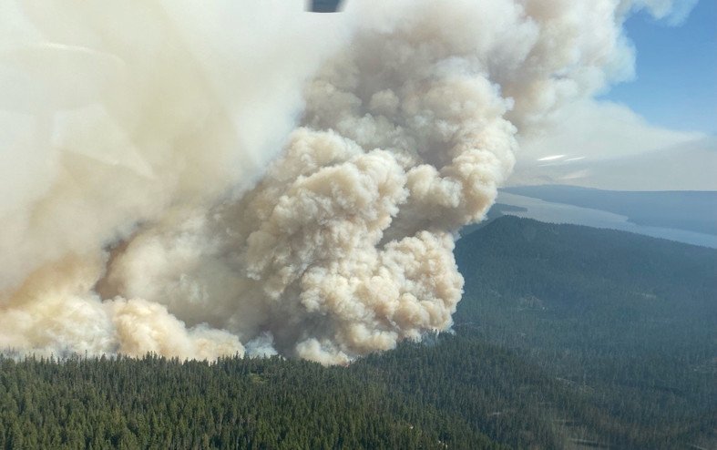
Cedar Creek Fire tops 74,000 acres, puts up tall pyrocumulus clouds, lightning; wind shift sends smoke back into C.O.
(Update: New info late Saturday night)
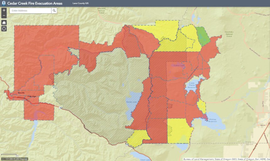
Oakridge still evacuated, Hwy. 58 still closed; some power restored
OAKRIDGE, Ore. (KTVZ) – The Cedar Creek Fire has more than doubled in size, topping 74,000 acres Saturday as winds shifted to push the blaze back toward the east, putting up towering pyrocumulus clouds that peppered the area with lightning and sent smoke again blowing into the High Desert.
“Easterly winds pushed the fire west until the early evening, when winds shifted and pushed towards the east,” fire officials said in a late Saturday night update on the fire’s Facebook page.
A late-Saturday update on the fire’s InciWeb page said the fire had reached 74,420 acres, with nearly 1,000 personnel battling it, and removed the earlier 12%c containment estimate.
“Giant pyrocumulus clouds formed directly above the fire, sending multiple lightning strikes into the fire footprint,” they said. “Lightning occurs when the clouds grow above 30,000 feet. These strikes did not influence the fire behavior.”
Despite the plume on the fire’s west side, it “did not make significant runs,” as it did on Friday, officials said late Saturday.
Thick, heavy smoke blanketed the fire Saturday, in, both the west and east zones, and ashfall was being reported over long distances amid some cooler temperatures.
Officials said seven task force teams of firefighters were prepared for direct and initial attack efforts overnight, strategically placed throughout the fire and surrounding communities with resources from the state fire marshal.
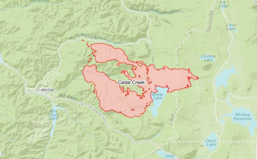
The fire remained north of state Highway 58, east of Kwiskwis Butte Road and south of Forest Road 19.
The fire grew by some 22,000 acres in 12 hours and 40,000 acres in a day, according to a Saturday afternoon posting.
The Oakridge, Westfir and High Prairie areas remained under a Level 3 (Go Now) evacuation order Saturday, although Lane Electric Cooperative said it had begun restoring power in some places, bringing in mutual-aid crews from other areas. The live, interactive evacuation level map is at https://lcgisorg.maps.arcgis.com/apps/webappviewer/index.html?id=fffd5cd4131d40bc885331fe3c905283
Officials said power restoration in the McKenzie area was delayed, requiring coordination with the Bonneville Power Administration, which also de-energized lines in the area as a precaution.
A red flag warning for critical fire weather stayed in effect until 11 p.m. Saturday.
Fire officials also noted that despite heat signatures showing on a map south of Oregon Highway 58 at Kitson Ridge, crews found no evidence of fire activity and said the fire had not crossed Highway 58.
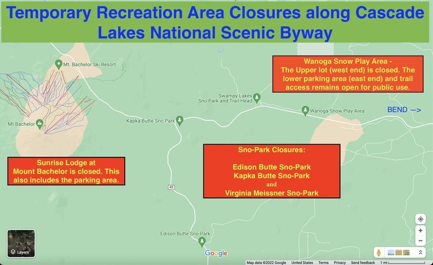
Among the widespread recreation impacts were closures to public access of the Edison Butte, Kapka Butte and Virginia Meissner sno-parks. Officials said the lower parking area at Wanoga Sno-Park remained open for public use and trail access, and Swampy Lakes Sno-Park and trailhead also remained open.
Sunrise Lodge at Mt. Bachelor and the parking area were closed for use as an incident command post for the fire’s East Zone, being used by Alaska Incident Management Team 1.
A long stretch of Highway 58 over Willamette Pass remained closed Saturday, from about milepost 13 at the Lowell Bridge on the west to Crescent Lake, milepost 70 on the east. ODOT advised motorists to take alternate routes and avoid the area. Check our TripCheck page for the latest.
Power shutdowns to reduce fire risk also were affecting other highways Saturday, ODOT said, advising travelers to watch for darkened traffic signals and debris in the roads. They also advised to expect heavy traffic late Saturday afternoon on Interstate 5 in Eugene around the Oregon Ducks football game.
Here's Saturday morning updates on the Cedar Creek and other large Oregon wild fires - remember that we have the state of Oregon's live wildfires dashboard on our Fire Alert page:
Cedar Creek Fire
September 10, 2022
Daily Update – 8:00 AM
Cedar Creek Fire Quick Facts
Size: 51,814 acres Contained: 12% Start Date: August 1, 2022 Location: 15 miles E of Oakridge, OR
Cause: Lightning Total personnel: 862 Resources: 29 engines 19 crews 46 heavy equipment 8 helicopters
Current Situation: Yesterday, Governor Kate Brown invoked the Emergency Conflagration Act. Level 3 evacuation level remains in place for the greater Oakridge, Westfir, and High Prairie area. Fire activity is expected to be high again today. East winds, low humidity, and high temperatures will continue today and start to ease tomorrow. Where winds align with terrain, tree canopy fire and fire spotting are anticipated. Fire will be carried by lichens and heavy fuels.
Status of the fire on the Willamette National Forest and West Zone: The fire has not crossed west of Highway 19; firefighters are working to hold and improve the east side. Spot fires crossed south of Highway 58 at Kitson Ridge. Firefighters are working to keep the fire north of Forest Road 1928. Today’s fire activity is expected to be extreme with long-range spotting and crown runs. Expect a large smoke column to develop by mid-morning. East of Waldo Lake, the Alaska Incident Management Team has established two branches and six divisions to work in the Deschutes National Forest side of the Cedar Creek Fire. Where possible, direct attack water drops with helicopters is occurring on the southeast edge. Crews are preparing Road 4290 from Charlton Lakes to the Cascade Lakes Highway to control the spread of the fire to the southeast.
To prevent the spread of the fire toward the east, efforts are focused on shaded fuel breaks 100-200 feet in depth on both sides of the Cascade Lakes Highway. Crews are working in the Brown Mountain area south of Crane Prairie Lake and working north. From the north, crews are working from the 2017 Nash Fire burned area near Elk Lake and improving the fuel breaks on both sides of the Cascade Lakes Highway working south. Additional contingencies are being scouted for east of the Cascade Lakes Highway.
Weather: A RED FLAG Warning is in effect today due to hot, dry, and windy conditions. East winds will continue today and switch to westerly winds tomorrow. Toward the afternoon the valley will become windy. Poor humidity levels overnight will allow for an extended burn window.
Closures: The Deschutes National Forest and Willamette National Forest have implemented closures for the Cedar Creek Fire. Please visit Willamette National Forest and Deschutes National Forest for detailed closure orders and a joint map. A Temporary Flight Restriction (TFR) is in place. The use of drones is prohibited in the fire area, please make it safe for our firefighters to use aircraft on the fire. Pacific Crest Trail hikers should visit pcta.org for current information.
Restrictions: Fire restrictions are in place on the Willamette National Forest and Deschutes National Forest.
Smoke: Smoke Forecast Outlooks are available at https://outlooks.wildlandfiresmoke.net/outlook.
Online: https://inciweb.nwcg.gov/incident/8307/ | https://www.facebook.com/CedarCreekFire2022/ |
YouTube: https://www.tinyurl.com/cedarcreekfireyoutube
Evacuations: Sign-up for emergency mobile alerts by going to oralert.gov Please check with Lane County Sheriff’s Office 541-682-4150 and Deschutes County Sheriff’s Office 541-693-6911 for updates and changes. Go to https://bit.ly/3D51kvC to view a map.
Fire Information: 8:00 AM – 8:00 PM | Phone: 541-201-2335 | Email: 2022.cedarcreek@firenet.gov
Van Meter Fire Update:
Incident Commander: Tyler McCarty, ODF Team 3
| Fire size: 2,502 acres | Structures lost: 2 homes, 7 other | Containment: 10% |
| Resources assigned: 457 | Fire information: 541-363-8140 | https://inciweb.nwcg.gov/incident/8405/ |
| Evacuations: https://www.facebook.com/KlamathSheriff | https://www.facebook.com/VanMeterFire |
Van Meter Fire
Klamath Falls, Ore. – Overnight, firefighters completed fireline around the southern end of the fire and continued to secure the perimeter in other areas. Matt Flock, Operations Section Chief, reminded resources at briefing “Completing that line helps to lock in the fire, but there is still an incredible amount of work left out there as we transition to mop-up and continue to widen the cold area around the fire.” Smoke may be visible today as unburned fuels within the fire are consumed.
As the work transitions to mop-up and securing fireline in the southern area of the fire, hose-lays will be constructed to provide water to all parts of the fire. Air resources will continue to provide support to moderate fire behavior as needed. In the northern area of the fire, where mop-up is already underway, firefighters will be patrolling for hotspots and smoke and gridding for heat. The goal is to widen the area from the established fireline toward the interior of the fire.
Structural resources will continue to monitor areas around homes, coordinating with wildland resources which will be working to grid for heat and cold trail these areas. Cold trailing is a process where firefighters look for signs of fire or smoke, feel the ground for heat, and use water to put out any areas where fire remains.
Due to minor growth Friday and improved mapping of the existing perimeter, the fire is currently 2,502 acres.
Evacuation levels will continue to be re-evaluated throughout the day. For the latest up-to-date evacuation information, please visit the Klamath County Sheriff’s Office Facebook page at https://www.facebook.com/KlamathSheriff or call 541-205-9730. An evacuation shelter has been established at the Klamath County Fair and Event Center in Klamath Falls for anyone displaced by the fire. Space for large and small animals is available as well.
Residential traffic is allowed, but to ensure public and firefighter safety the public is asked to stay out of the fire area. Bureau of Land Management lands in and around the fire area remain closed to the public.
No reportable accidents have occurred on the fire. Falling snags and trees, ash pits and rattlesnakes continue to be safety concerns for firefighters on the line.
Low humidity and high temperatures remain in the forecast with some increased wind activity.
A Temporary Flight Restriction exists around the fire to limit any aircraft not associated with firefighting activities in the airspace. Wildfires are always a no-fly zone for drones. A drone flying in the area can ground all operational aircraft and impact suppression activities.
Double Creek, Sturgill, Nebo, Goat Mountain Two Fires
September 10, 2022
Daily Update – 8:00 AM
Highlights: The cooler weather has moderated fire behavior somewhat in the timber, but the fire is still actively spreading in the grass. Structure protection preparations are complete along Lostine Road. Oregon State Fire Marshal (OSFM) task forces continue to assist with operations on the south side of Double Creek.
Double Creek Fire: 147,582 acres | 15% contained | 796 personnel assigned The west side of the fire has been secured and Upper Imnaha Road from Imnaha to Freezeout Road is in patrol status. The fire continues to actively spread in the dry grass on the north, east, and south side of the fire. Firefighters are working in Horse Creek drainage on the north side of the fire to secure structures and look for opportunities to build control line to the east. River boats are being used to patrol and assess structure protection needs along the Snake River. Firefighters continue to protect structures along Upper Imnaha Road on the south side of the fire and to scout for potential control lines to tie the road to the Snake River to the east. The OSFM task forces are engaged in structure protection preparations in Imnaha River Woods four miles south of the fire's edge.
Weather: Elevated fire weather conditions occurred yesterday with wind out of the northeast and very dry conditions. Similarly sunny and dry conditions are expected again today, but with a wind coming from the south. It is important to note that we will not be experiencing the conditions that are the cause for the Fire Weather Watch on the west side of the Cascades.
Smoke: The Oregon Department of Environmental Quality (DEQ) has issued an Air Quality Advisory that is in effect until 2:00 p.m. Saturday for Wallowa, Union, Deschutes, and Umatilla Counties. For additional information, visit the DEQ website. A smoke outlook for northeast Oregon is available from the wildland fire air quality response program. Additional information can be found at PurpleAir website.
Evacuations: Level 3 “Go Now” is in effect for the Town of Imnaha north to the Snake River at Dug Bar and south to Highway 39. Level 2 “Get Set” is in effect for Lostine River Road from Fir Road south to Two Pan (including all campgrounds and trailheads). Level 1 “Be Ready” is in effect for Lostine River Road from Highway 82 to Fir Road.
Wallowa Whitman National Forest Temporary Area Closures: The Wallowa Whitman National Forest issued Temporary Area Closures for the Double Creek Fire, Nebo Fire, and Sturgill Fire (includes Goat Mountain 2 Fire) on Monday. Closure Orders and Maps are available on the Wallowa Whitman National Forest Fire Incident Updates page.
Wallowa County Road Closures: Lostine River Road from Moffitt’s south is closed. Lower Imnaha Road and Dug Bar Road are closed. Upper Imnaha Road is closed. Hat Point Road is closed. FS 39 Road is closed from Target Springs Junction to Ollokot Campground [including the Canal Rd (3920) and Lick Creek Road (3925)].
Oregon Department of Transportation (ODOT) Closures: Highway 350 (Little Sheep Creek Highway) in Wallowa County is closed between milepost 6 and milepost 29, where the highway ends. Local traffic will be allowed. https://www.tripcheck.com/
Airspace: Airspace restrictions have been issued for the Double Creek, Nebo, Sturgill, and Goat Mountain 2 Fires. Temporary Flight Restrictions were updated for the Double Creek Fire (TFR 2/4975) and the Sturgill Fire (TFR 2/3189) to provide a safe environment for firefighting aircraft operations over the fires. Notice to Air Missions (NOTAM) 08/234 and NOTAM 08/235 were issued to provide safe airspace for the Nebo and Goat Mountain 2 Fires. Flight restrictions also apply to drones. Drones flying in areas of wildfire activity will cause firefighting aircraft to be grounded.
Restrictions: Forest Order #06-16-00-22-04 covers Phase B Fire Restrictions for all National Forest System Lands within the Wallowa-Whitman National Forest, except for the area within a ¼ mile of the Snake River between Hells Canyon Dam, River Mile 247.5, downstream to the Oregon-Washington border at Snake River Mile 176.0, which is regulated by Forest Order #06-16-04-22-01.
Fire Information
Office Hours: 8:00 AM – 8:00 PM
Phone: 541-216-4579
Email: 2022.doublecreek@firenet.gov
InciWeb: https://inciweb.nwcg.gov/incident/8366/
Facebook: www.facebook.com/doublecreekfire2022
YouTube: https://tinyurl.com/Double-Creek-Fire
Crockets Knob Fire Update
NORTHWEST INCIDENT MANAGEMENT TEAM 12
Incident Commander: Bobby Shindelar
September 10, 2022
Today is Northwest Incident Management Team 12’s last day on the Crockets Knob Fire. Management of remaining firefighting resources will transition to the High Desert Type 3 Incident Management Team tonight. Northwest IMT 12 would like to thank the Prairie City School District for hosting our team and the local community for your support and hospitality!
Weather: East winds will be gusty in the morning but will become calmer by the afternoon. Temperatures will be slightly warmer today with highs in the low-80s. Conditions will still be dry with relative humidity dropping into the low teens.
Operations: Yesterday fire activity was minimal, allowing firefighters the opportunity to mop up remaining heat along containment lines. Crews also continued pulling hoses and excess equipment from containment lines. Chipping and cleanup were ongoing along FSR 45 yesterday and will continue today. Resource advisors are assessing the impacts of the fire suppression activities. They are determining what repair work may be required to protect natural and cultural resources and minimize the potential for future erosion. Helicopters assisted local small fires yesterday and will be available to assist the Crockets Knob Fire and initial attack fires today as needed.
Closures and Evacuations: Grant County has lifted the Level One evacuation advisory in the area of the fire, and County Road 20 (Middle Fork Road) has been fully reopened. Today the closure area remains in effect on the Malheur and Umatilla National Forests. Sunday the Forests will be decreasing the closure area. For complete closure information, please go to: https://www.fs.usda.gov/detail/malheur/notices/.
Smoke may be visible to nearby communities and Forest visitors. Smoke and air quality impacts within the state can be monitored by visiting: http://oregonsmoke.blogspot.com
The Malheur National Forest’s Public Use Restriction is Phase C on the Blue Mountain and Prairie City Ranger Districts. No campfires or personal chainsaw use is allowed. The Umatilla National Forest remains in at Phase B, which allows campfires only in designated campgrounds and recreation sites. For more information, please go to: https://www.fs.usda.gov/detail/malheur/fire, and https://www.fs.usda.gov/detail/umatilla/alerts-notices.
Fire Danger remains High for the surrounding area. The vegetation is still very dry, and one spark or ember could start a significant fire. The public can help us by making good decisions when they recreate on public lands and by following local fire restrictions.
Quick Facts:
SIZE: 4,331 Acres
CONTAINMENT: 60%CAUSE: Lightning
PERSONNEL: 448
LOCATION: 19 miles north of Prairie City
FIRE INFORMATION: 541-625-08922022.crocketsknob@firenet.gov
FACEBOOK: https://www.facebook.com/CrocketsKnobFire
INCIWEB: https://inciweb.nwcg.gov/incident/8355/
TEMPORARY FLIGHT RESTRICTION: There is a Temporary Flight Restriction over the Crockets Knob Fire area. Wildfires are a No Drone Zone - if you fly, we can’t.
Rum Creek Fire Morning Update for Saturday, Sept. 10
Quick Stats -
Acreage - 21,347
Resources Assigned - 1,042
Containment - 55%
Fire Information: 541-625-0849
InciWeb: https://inciweb.nwcg.gov/incident/8348/
Evacuations: https://tinyurl.com/JOCOEvacMap
Road closures still in place at Rum Creek Fire
MERLIN, Ore. – While evacuation levels have been reduced near the Rum Creek Fire, road closures are still in place. Only residents (must show proof of residency) are allowed past the roadblocks.
The public is reminded not to drive past or around road closures, as this creates a hazard for firefighters and residents trying to return home. There are reports of people driving at excessive speeds, not paying attention to the road or traffic, or taking their half of the road out of the middle. Traffic congestion interferes with movement of fire equipment and personnel working on the fire, and may impede the response to a flare-up. If you do not need to be in the fire area, please stay out.
Burned areas are hazardous for people to enter. Dead and green burned trees can fall, often without warning. Burned areas that have not been cooled may have smoldering stump holes and deep pockets of hot ashes. Stepping into these can cause serious injury. Even with extensive training, firefighters are killed or injured by these fire hazards every year.
The Red Flag Warning and Heat Advisory issued by the National Weather Service extend into this evening. Friday night’s very dry, warm conditions were described by Fire Behavior Analyst Nate Perrine as “like day shift for fire activity, but dark.” Relative humidity levels will be critically low again today, below 10% in some areas. Wind gusts up to 18 mph from the southeast are expected at Rum Creek Fire, along with high temperatures around 100 degrees.
Despite the critical fire weather Friday, the Rum Creek Fire stayed within its footprint with no acreage gain. One interior flare-up was suppressed using water drops from helicopters to ensure fire did not threaten the containment line. On most of the fire, personnel took advantage of the increased fire behavior to continue mop up near the fire’s edges. Containment has increased to 55%.
A group of firefighters is staying in a temporary camp near the northwest edge of the fire, to avoid the long transportation time into this remote area. This allows firefighters to easily monitor and work on the fire overnight and during the day. With winds from the southeast in the forecast, having eyes on this area is critical to keeping fire within containment lines.
After today, fire weather is expected to abate, with cooler temperatures and higher relative humidity. After the extensive dry spell, fuels remain dry and the potential for new fire starts will stay high. Any new fire is expected to spread rapidly. Resources from the Rum Creek Fire are available to help with initial attack on new fire starts nearby.
The unmanned aerial system (UAS) has been reassigned to a fire with greater need for its special functions. On the Rum Creek Fire, the UAS assisted with aerial reconnaissance, infrared mapping, and tactical ignitions.
Evacuations: Evacuation orders and notifications have not changed. An interactive map showing evacuation levels according to address can be found at //JosephineCounty.gov/FireMap. For the most current evacuation information and resources, go to Josephine County Incident Information (rvem.org).
Road control: Josephine County Sheriff’s Office has established traffic access points around the fire zone. Road blocks are located at Galice Road near Crow Road; Galice Store; Bear Camp Road at Peavine (top intersection); Lower Grave Creek Road at Angora Creek (Grays Ranch); Quartz Creek Road about 3 miles up (end of County maintenance); Dutch Henry Road near Kelsey Creek (42 44'56.2/123 40'35.4); and Hog Creek at Galice Road. Only residents (must show proof of residency) and permitted users will be allowed through.
River status: The Wild section of the Rogue River below Grave Creek will remain open unless fire conditions warrant closure. River status is determined on a day-to-day basis. Please call 541-471-6535 for more information regarding Rogue River permits. No new boating permits will be issued at this time.
