Pile burning returns: Operations getting underway on the Deschutes and Willamette national forests
BEND, Ore. (KTVZ) -- Firefighters across the Deschutes National Forest plan to begin pile burning as favorable conditions exist, officials said Monday.
Firefighters select pile burning units for ignition based on moisture levels, forecasted weather and conditions predicted to move smoke away from communities where possible.
Firefighters primarily plan to start with higher-elevation piles. Ignitions could begin as soon as Monday and last through January.
The Bend-Fort Rock Ranger District plans to implement pile burning in areas west of Bend, west of Sunriver and southeast of La Pine. Ignitions could begin as early as Wednesday.
Crescent Ranger District firefighters plan to conduct pile burning across the district, including southeast of Crescent near Windigo Pass, northwest of Crescent in the Forest Service Road 1668 area, west of Crescent near Odell Butte, and northwest of Crescent in the Davis Mountain area.
The Sisters Ranger District firefighters plan to conduct pile burning in a variety of locations, including the Melvin Butte area southwest of Sisters, the Green Ridge area northeast of Sisters, and areas around Camp Sherman. If conditions are favorable, firefighters will start ignitions on piles in the Melvin Butte area today.
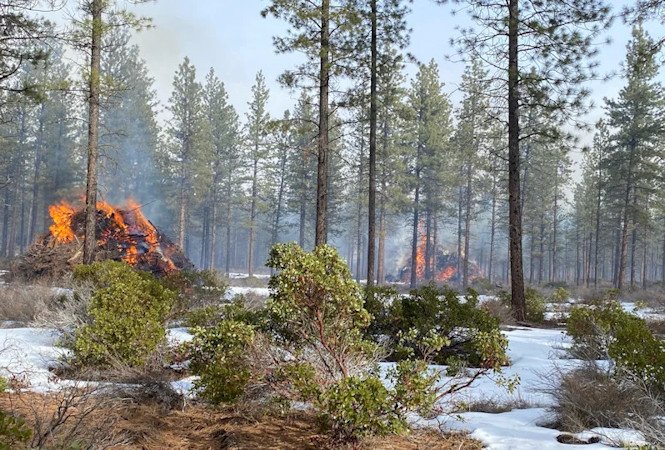
Piles may smolder, burn, and produce smoke for several days after ignition. Once ignited, firefighters monitor piles until they are declared out. Please do not report ignitions.
While smoke may linger in the area, removing these large accumulations of woody debris during the winter months minimizes fire danger. The piles are concentrations of leftover materials associated with vegetation management activities being done to help maintain and restore forest and ecosystem health while reducing hazardous fuels loading.
What does this mean for you?
The possibility exists for smoke to settle in low-lying areas due to cool night-time temperatures.
- When driving in smoky areas, drivers should slow down and turn on headlights
- If you have heart or lung disease, asthma, or other chronic conditions, ask your doctor about how to protect yourself from smoke
- Go to centraloregonfire.org to learn more about smoke safety and pile burning in Central Oregon
For more information on hazardous fuels reduction projects in Central Oregon, visit centraloregonfire.org/ or fs.usda.gov/deschutes and follow us on Twitter @CentralORFire. Text “COFIRE to 888-777 to receive wildfire and prescribed fire text alerts.
This work is occurring within the Central Oregon Landscape, one of 21 focal landscapes identified within the Forest Service’s Wildfire Crisis Strategy. The implementation of this work supports the Deschutes National Forest’s commitment to addressing the Wildfire Crisis Strategy which aims to reduce severity of wildfires, protect communities, and improve the health and resiliency of fire-dependent forests.
--
Pile burning taking place on the Willamette National Forest
Springfield, Ore., Oct. 16, 2023— Pile burning is underway on the Willamette National Forest due to the cool, damp fall weather. Throughout the fall, trained firefighting personnel will ignite the slash piles while fire danger is low and monitor them to ensure fire does not spread outside the immediate vicinity.
Burning will be weather-dependent and only occur if conditions are deemed ideal by firefighters. Restoration projects, vegetation management, noxious weed removal, and other brush clearing activities generated the slash piles. Burning is one of the most effective ways to remove non-merchantable woody debris from the forest before it becomes a hazardous fuel in the dry summer months.
Pile burning operations are anticipated on all four ranger districts this week:
- Detroit Ranger District: Burning planned Oct. 16-19. Piles located near Detroit Lake on Highway 22, Forest Service Road (FR) 46, and FSR 10. Smoke may be visible from Highway 22, FR 46, and Stahlman Summer Homes.
- Sweet Home Ranger District: Burning planned Oct. 16-19. Piles located approximately three miles west of Tidbits Mountain. Smoke may be visible from Owl Creek Road, FR 2027, and FR 2026.
- McKenzie River Ranger District: Burning planned Oct. 16-19. Piles located along FR 19, near Highway 126 at milepost 54, and near East King Road. Smoke may be visible from McKenzie Bridge, Rainbow, and FS 19.
- Middle Fork Ranger District: Burning planned Oct. 16-17. Piles located northeast of Oakridge in the Dead Mountain area.Smoke may be visible from Oakridge and Westfir.
Smoke may be visible from nearby trails, roadways, and waterways while the burns are in progress. Smoke impacts are expected to be minimal, and no area closures are anticipated. If unsure whether smoke or a fire is from a planned pile burn, people can contact their local fire department, county emergency services, or a nearby Willamette National Forest Ranger Station. Firefighter and public safety are always the top priority during any burning events.
For more information on future prescribed fire and pile burning operations, visit the alerts section on our website at www.fs.usda.gov/willamette or follow the Forest on Facebook and X, formally known as Twitter, @willametteNF for more updates.
