Red flag, excessive heat warnings point to dangers not just for firefighters
Matthew Draxton will have more on heat impacts in report at Five
REDMOND, Ore. (KTVZ) -- The National Weather Service in Pendleton issued a new red flag warning for much of the region for dry and unstable conditions bringing high fire danger, in effect until 11 PM Tuesday.
Due to the hot temperatures and increasingly dry conditions, officials raised the fire danger level to extreme for public lands across Central Oregon. That includes lands managed by the Forest Service, BLM and Oregon Department of Forestry.
Redmond Fire and Rescue said Monday that "all recreational fires are banned until the red flag warning expires."
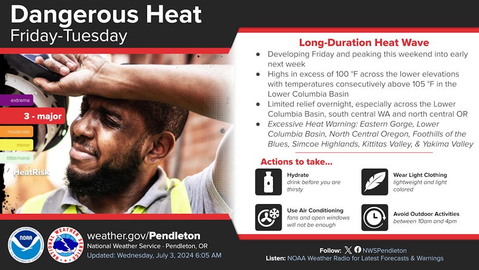
An excessive heat warning also was put in place for the region through 10 p.m. Wednesday for "dangerously hot conditions with limited overnight relief," meaning high temperatures of 95 to 110 degrees and lows in the mid-50s to lower 70s, which "will pose a major risk of heat-related illnesses."
...HOT, DRY AND UNSTABLE ALONG WITH BREEZY WINDS TUESDAY THROUGH
LATE WEDNESDAY...

.High pressure that has brought the hot temperatures the past
weekend is showing signs of breaking down. The instability will
increase as a result, and the combination of hot, dry and
unstable weather warrants Red Flag Warnings and Fire Weather
Watches. In addition, breezy winds will develop through the
Cascade gaps and into portions of the Columbia Basin Wednesday
and will coincide with low relative humidities in the afternoon
and evening.

ORZ610-611-639-640-WAZ694-695-090130-
/O.CON.KPDT.FW.W.0004.240708T1900Z-240710T0600Z/
East Slopes of Central Oregon Cascades-Deschutes National Forest -
minus Sisters Ranger District-
East Slopes of the Northern Oregon Cascades-
Central Mountains of Oregon-Yakama Alpine District-
East Washington South Central Cascade Mountains-
1019 AM PDT Mon Jul 8 2024

...RED FLAG WARNING REMAINS IN EFFECT UNTIL 11 PM PDT TUESDAY FOR
DRY AND UNSTABLE CONDITIONS FOR FIRE WEATHER ZONES OR610, OR611,
OR639, OR640, WA694, AND WA695...

* AFFECTED AREA...Fire Weather Zones 610 East Slopes of Central
  Oregon Cascades, 611 Deschutes National Forest  -minus Sisters
  Ranger District, 639 East Slopes of the Northern Oregon
  Cascades, 640 Central Mountains of Oregon, 694 Yakama Alpine
  District and 695 East Washington South Central Cascade
  Mountains.

* TIMING...Today through Tuesday night.

* WINDS...North 10 to 15 mph.

* RELATIVE HUMIDITY...As low as 8 percent.

* TEMPERATURES...Up to 105.

* IMPACTS...Any new and existing fires have a strong potential
  for extreme fire behavior.

* HAINES...As high as 6.

PRECAUTIONARY/PREPAREDNESS ACTIONS...

A Red Flag Warning means that critical fire weather conditions
are either occurring now, or will shortly. A combination of
strong winds, low relative humidity, and warm temperatures can
contribute to extreme fire behavior.
--
John Day Basin-Central Oregon-
Including the cities of Madras, Prineville, Redmond, John Day,
Bend, Mitchell, Monument, Spray, and Dayville
108 PM PDT Mon Jul 8 2024

...EXCESSIVE HEAT WARNING REMAINS IN EFFECT UNTIL 10 PM PDT
WEDNESDAY...

* WHAT...Dangerously hot conditions with limited overnight relief.
  Afternoon high temperatures of 95 to 110 degrees. Overnight low
  temperatures in the mid-50s to lower 70s. This will pose a major
  risk of heat-related illness.

* WHERE...Central Oregon and John Day Basin.

* WHEN...Until 10 PM PDT Wednesday.

* IMPACTS...Heat-related illnesses increase significantly during
  extreme heat events.

* ADDITIONAL DETAILS...Hottest temperatures during this
  long-duration heatwave are expected Tuesday.

PRECAUTIONARY/PREPAREDNESS ACTIONS...

Drink plenty of fluids, stay in an air-conditioned room, stay out of
the sun, and check up on relatives and neighbors.

Do not leave young children and pets in unattended vehicles. Car
interiors will reach lethal temperatures in a matter of minutes.

Take extra precautions when outside. Wear lightweight and loose
fitting clothing. Try to limit strenuous activities to early morning
or evening. Take action when you see symptoms of heat exhaustion and
heat stroke.

Stay cool, stay hydrated, stay informed.

