Falls Fire north of Burns tops 91,000 acres, 0% contained; 1,400 firefighters on it; fire less active than predicted

(Update: Wednesday update)
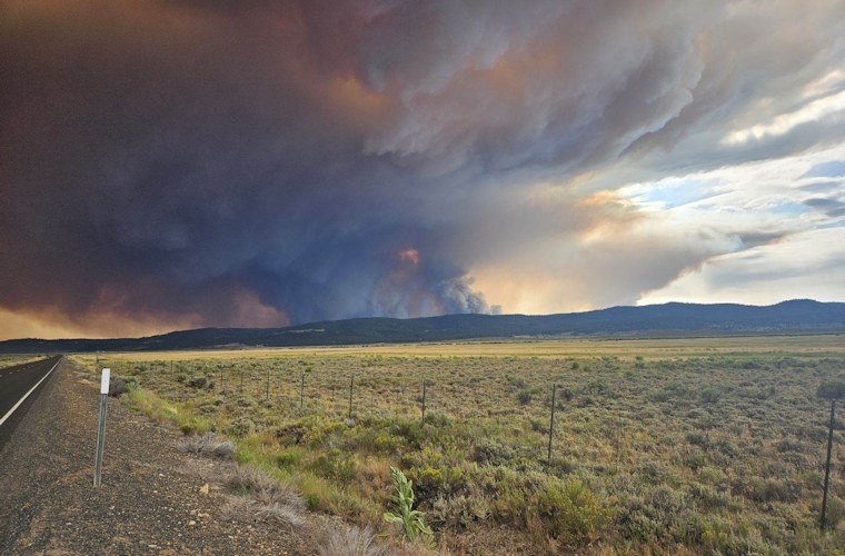
BURNS, Ore. (KTVZ) – The week-old Falls Fire burning in Harney and Grant counties about 13 miles north of Burns continues to grow, now topping 91,000 acres, as does a firefighting force now at more than 1,400 personnel. It's still at zero containment amid evacuations, but nearby U.S. Highway 395 is now open without traffic escorts.
The Oregon State Fire Marshal has activated seven task forces of engines and other equipment to respond to Falls Fire structure protection needs.
Tuesday morning fire update:
Visit the fire's Facebook page for the latest information)
The Falls Fire was less active yesterday than predicted. The fire acreage is now estimated to be 91,269 with 0% containment. The fire is burning approximately 13.5 miles north of Burns, 15 miles southwest of Seneca, and 3 miles west of Highway (Hwy) 395. Hwy 395 was reopened yesterday at approximately noon.
HWY 395 is now fully open once again, with no patrol cars or flaggers, officials said Wednesday afternoon.
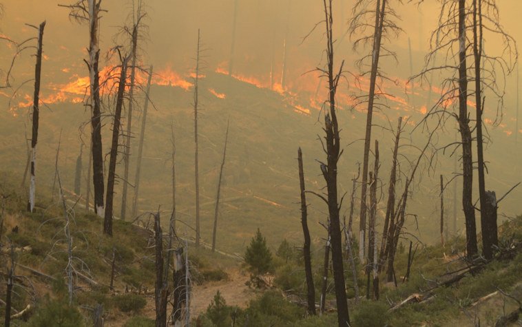
Yesterday, the fire was not as active and growth was relatively moderate despite predicted conditions. Control lines along much of the south and west portions of the fire, along Forest Service Road (FSR) 43, held firm with only a few problem spots that were lined and mopped up. Significant progress was made at the northwest corner of the fire along FSR 4310 where firefighters were able to “turn the corner” and build direct dozer and hand line.
Along the northeast and eastern areas of the fire perimeter, firefighters were able to construct both direct and indirect control lines where conditions allowed for safe operations. At the southeastern corner of the fire, firefighters were able to keep the fire from coming out of the Lake Creek drainage. Efforts to establish dozer line to tie into the Silvies River area over to FSR 3110 area continued to make progress. Mop-up operations continue along FSR 43.
Aerial resources, including five helicopters, six single-engine air tankers (SEATs), two large air tankers (LATs), and two very large air tankers (VLATs) helped to slow the fires growth, and supported firefighters as they made progress constructing and securing containment lines.
Today, fire behavior is predicted to be heavily influenced by multi-directional winds. There is an increased possibility of thunderstorms in the area which will produce downdraft winds. New line construction efforts will focus on extending line from the northwest corner of the fire moving to the east across the northern flank. Crews will construct direct and indirect control lines along the northeast and southeast flanks in the FSR 31 area. Efforts to secure line between FSR 3120 and Lone Pine Road will continue. Mop-up operations will continue on portions of the southern and western areas of the fire along FSR 43. Firefighters will continue to scout for future control lines to the north and east.
Yesterday, Oregon State Fire Marshal structure teams were able to document homes and outbuildings that were lost early on in the fire. Ten residences were lost and thirteen “other” structures were also destroyed. The term “other” could be campground buildings, pump houses, sheds, shops, lean-tos and other small buildings. Information for damaged and lost assets will be delivered to Harney County. Community members with questions can contact the Non-Emergency County Information Line at 541-589-5579.
Last night, OSFM night crews focused on the Lone Pine burnout operations and holding triaged homes along the southern edge of the fire. Today, they will continue patrolling the Hines Logging Road and the Lone Pine Road. Two task forces will continue to identify buildings and complete the triaging process along the 31 Road and Hwy 395. Triaging includes establishing water supply, removing fuels near structures, identifying firefighter hazards, and supporting any burnout operations near assets. Structure firefighters will progressively work their way north to the town of Seneca.
There has been a significant arrival of resources on the fire to help with fire suppression efforts. Currently there are 1,413 personnel on the fire; this includes 48 20-person hand crews, 79 fire engines, 17 bulldozers, and 24 water tenders.
Today’s predicted weather includes cloudier conditions with an increased possibility of thunderstorms in the general area around the fire that could produce strong outflow winds. Winds in general are predicted to be erratic, shifting, and multi-directional. Temperature highs will be 90 – 98 degrees and relative humidity around 15%.
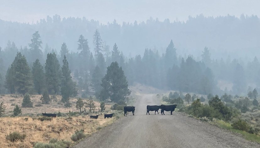
Evacuation notices remain in effect in Grant and Harney Counties. For the most accurate evacuation information, please visit the Harney County Sheriff’s evacuation map here: https://tinyurl.com/3zst4sjy, or the Grant County Emergency Management Facebook page at: https://www.facebook.com/profile.php?id=100068819321423.
The Malheur National Forest issued a fire area closure. A detailed map and additional information about the fire area closure are available at: https://www.fs.usda.gov/detail/malheur/news-events/.... A temporary flight restriction (TFR) remains in place over the fire area.
Please continue to do your part to prevent human caused wildfires and remember that #onlyyoucanpreventwildfires! Know Before You Go and check for fire restrictions in areas you are living and visiting.
Harney County Emergency Management
U.S. Forest Service-Malheur National Forest
--
Sunday notice from Grant County Emergency Management:
The American Red Cross is operating a shelter for evacuees from the Falls Fire. The shelter is located at the Grant County Fairgrounds, Trowbridge Pavilion, in John Day. There is a limited number of animals from evacuated locations that can be accommodated there as well.
The Harney and Grant County evacuation areas map can be found here.
To view a GIS version of the evacuation map: https://harneycounty.maps.arcgis.com/.../index.html...
--
Forest Service news release:
JOHN DAY and HINES, Ore. - The Malheur National Forest has issued a new area closure for the Falls Fire. To protect public health and safety, fire managers have closed the area around the fire due to fire activity and fire suppression operations. This updated closure will be effective July 14, 2024, through December 31, 2024, unless rescinded sooner.
Closure Area Description:
· Starting at the junction of Highway 395 and the Malheur National Forest boundary, going east and north along the forest boundary to the intersection with Forest Road 15.
· Heading north on Forest Road 15 to the junction with Forest Road 16.
· Forest Road 16 west to the junction of Highway 395.
· North on Highway 395 to the junction of Grant County Road 63 (Izee Highway).
· Grant County Road 63 southwest to the Malheur National Forest Boundary following the forest boundary around the southern portion of the Emigrant Creek Ranger District to the intersection of Highway 395 and Malheur National Forest Boundary.
--
OSFM sending firefighters, incident management team to Falls Fire in Harney County
Oregon State Fire Marshal - 07/14/24 12:38 PM
SALEM, Ore. - The Oregon State Fire Marshal is sending its Blue Incident Management Team and four task forces to the Falls Fire burning 20 miles northeast of Riley in Harney County.
Hot, dry, and windy conditions caused the fire to grow rapidly on Saturday, pushing it to 55,000 acres with zero percent containment.
“Within the last week, we mobilized three incident management teams to fires across Oregon. This highlights the substantial fire danger we are seeing,” Oregon State Fire Marshal Mariana Ruiz-Temple said. “With dry lightning expected to hit east of the Cascades on Sunday, I can’t stress enough the importance of taking action to prevent sparking another wildfire.”
The Grant and Harney County sheriffs' offices have evacuation orders in place. A map of Harney County evacuations can be found here. Grant County evacuations can be found here.
For fire information, please follow the Falls Fire Facebook Page or the Falls Fire InciWeb page.
