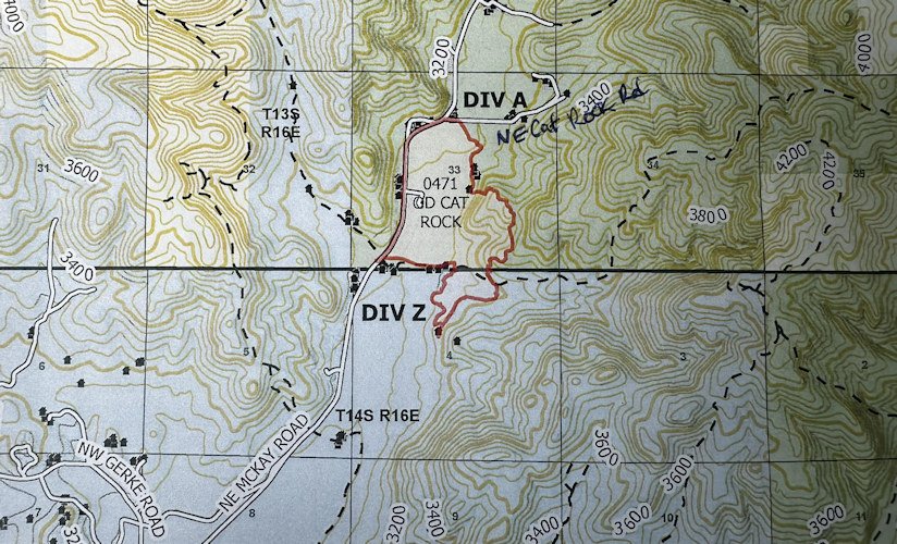
219-acre Cat Rock Fire off McKay Creek Road north of Prineville now 30% contained, drops to Level 1 evacuation notice

(Update: Fire now 30% contained, evacuation notice down to Level 1)
PRINEVILLE, Ore. (KTVZ) – The Crook County Sheriff's Office on Monday morning reduced the evacuation notice to Level 1 BE READY for a wildfire fanned by heat and wind that broke out Saturday afternoon near McKay Creek Road, about six miles north of Prineville, burning over 200 acres and brought by 100 firefighters to 30% containment.
The Cat Rock Fire was reported shortly before 3:30 p.m. Saturday and first reports from the sheriff’s office indicated it had burned 20 to 30 acres and was moving south and southeast in grass, brush and timbers, threatening structures. Later, an estimate put the size at about 500 acres, later mapped to a reduced 219 acres.
Monday's update:
PRINEVILLE, Ore. – With warm, dry conditions persisting over the fire area, the Cat Rock Fire north of Prineville in Crook County remains at an estimated 219 acres. The forecast weather shows temperatures remaining in the mid 90s with light winds from the northeast. These conditions aren’t expected to cause control issues but may cause smoldering of unburned fuel within the fire perimeter. Fire containment is currently estimated at 30 percent.
The Central Oregon Type 3 Incident Management team is in place, with approximately 100 firefighters on the ground. Today fire personnel continue to protect structures along the McKay Creek corridor and east of the McKay Creek Road. In addition, crews and engines continue mopping up the fire perimeter and hot spots.
Infrared flights using an Unmanned Aircraft System (a drone) were conducted by Crook County Sheriff’s Department. The collected images will be utilized to identify and address any areas of concern. Crook County law enforcement, in consultation about fire conditions with ODF, reduced evacuation levels to a Level 1 (Get Ready) starting today on McKay Creek Road near the Cat Rock intersection all the way to the Dry Creek Road intersection.
The fire’s cause is still currently under investigation.
For more information on the Central Oregon District and fire season regulations, visit https://odfcentraloregon.com/. Check your local restrictions at https://www.oregon.gov/odf/fire/pages/restrictions.aspx.
After consulting with the Incident Commanders with the Oregon Department of Forestry and Crook County Fire & Rescue, the evacuation level will be reduced to LEVEL 1 as of 7:00 am.
Various state, private, and federal fire entities are still on the scene to ensure the fire is out. Today's goal is to complete a hose line around the contained fire and extinguish any hot spots.
CCSO will fly the fire this morning with one of our drones to check for hot spots.
The cause of the fire is still under investigation by ODF, CCFR, and CCSO members. The cause of the fire is yet to be determined. Any future press releases concerning the fire will be provided by ODF.
--
Earlier info:
The east side of NE McKay Creek Road been at Level 3, then Level 2 between Dry Creek and Cat Rock Road, as fire crews worked to reinforce the lines.
While McKay Creek Road was open to traffic, the sheriff's office urged motorists to driver slowly in the area, as equipment and personnel were moving in and around the fire scene.
Kelsey McGee is heading to Prineville on Sunday to talk with fire officials and area residents. She's also reaching out to the fairgrounds to see if anyone brought their livestock there when they had to evacuate. Her report will be on NewsChannel 21 at Six.
Federal, state and Crook County Fire & Rescue crews tackled the blaze, with several aerial resources also on scene, including air attack, air tankers and a helicopter supporting engines on the ground.
In the first of a series of videos on the sheriff’s office Facebook page, Lt. Mitch Madden said the Level 3 GO NOW was for about a mile south of the intersection of McKay Creek and Gerke roads and a mile north of the intersection with NE Cat Rock Loop.
“Please evacuate if you can,” Madden said, also asking others to stay out of the area so firefighters can do their work. Madden also said the west side of McKay Creek was not in danger.
A Level 2 BE SET pre-evacuation alert was issued from the 1800 block of McKay Creek Road south to NE Dry Creek Road.
Undersheriff Bill Elliott said a shelter was being set up at Gary Foster Hall at the Crook County Fairgrounds for any livestock that needs to be moved. He said Barn 13 has 20 stalls they can move animals to.
In an update around 7:30 p.m., Madden said crews were still fighting the blaze, dropping retardant, and said people are not allowed up McKay Creek Road.
"We're trying to put the fire out as quickly as he can," Madden said.
Around 9:30 p.m. Madden said the Level 3 evacuation along McKay Road had been lowered to Level 2, allowing people to return to their homes, but advising they need to be ready to go in case the fire flares up again.
"Fire and law enforcement personnel will remain in the area throughout the night.," a sheriff's office posting late Saturday night said, adding, "At this time, the cause of the fire is unknown."
Madden also said earlier that power was cut in the area, and Pacific Power's outage map showed 94 customers under an emergency de-energization. The map later showed that outage had ended, but an area northwest of Prineville had anear 800 customers in a new outage that was investigated and resolved.
