Pyramid, Ore fires each burn about 500 acres, largest of 22 lightning-sparked fires tackled on Willamette Natl. Forest
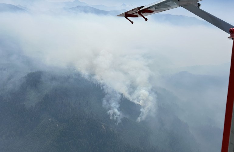
SPRINGFIELD, Ore. (KTVZ) -- Before Sunday's thunderstorms moved through Oregon, last week's lightning sparked nearly two-dozen blazes on the Willamette National Forest, including the Pyramid and Ore fires that by Sunday had each burned over 500 acres in rugged terrain.
Here's a forest overview Sunday and details of the two blazes:
Willamette National Forest
Fire Update - July 21, 2024
Interagency fire crews have been tracking and fighting 24 wildfires across the Willamette National Forest since last Monday, including 22 that were sparked by a lightning storm overnight on Tuesday that recorded more than 200 down strikes in Lane County and more than 1,000 lightning strikes across the state.
Because of a rapid initial attack and aggressive fire suppression, 10 of those wildfires have been contained or controlled in the past week. Crews are working hard, and resources are stretched across the region to meet the need as new starts are detected. Total fires on the landscape this week included 14 fires in the Middle Fork Ranger District, 6 fires in the McKenzie River Ranger District, and 4 fires in the Santiam River Zone and Sweet Home Ranger District.
Areas of focus include the Pyramid Fire, the Ore Fire, and the High Prairie Fire, among others. One Complex Incident Management Team (CIMT) took command of the Ore Fire on Saturday, and another CIMT was in-briefed for the Pyramid Fire in the Sweet Home Ranger District.
Fire closure orders for public and firefighter safety were issued today for 3 more fires in the Middle Fork Ranger District: the Chalk Fire, the Tire Mountain Fire, and the Moss Mountain Fire near the Diamond Peak Wilderness.
Fires that are contained or controlled include: Skipper, Alpine, Deer Creek, Deer Butte, 199 MR, 202 MR, 226 MR, 212 SRZ, 225 SRZ, and Westfir-Oakridge Rd.
The public is encouraged to stay safe, observe closures, pay attention to evacuation warnings, and avoid active wildfire areas to give firefighters and first responders the room they need to move heavy equipment and work. Visitors are encouraged to support firefighters and crews by recreating elsewhere in the coming days, especially with more lightning activity on the horizon.
--
PYRAMID FIRE
INCIDENT UPDATE
Date: July 21, 2024
facebook.com/Willamette Fire Information: 541-208-1264
Hours: 08:00AM to 8:00PM
x.com/willametteNF Email: 2024.Pyramid@firenet.gov
Location: Linn
County, CA
Size: 500 acres
Cause: Lightning
Start Date: Wednesday July 17, 2024
Percent Contained: 0%
Personnel: 94
CURRENT SITUATION:
This morning at 6:00 AM, California Interagency Incident Management Team 5 assumed command of the Pyramid Fire. The fire is burning in old-growth forests with heavy timber and steep rugged terrain, making access difficult for firefighters. Crews have been constructing indirect containment lines using heavy equipment, opening up old roads, and clearing trails in an effort to keep the fire from spreading into the Middle Santiam Wilderness, private industrial timberlands, and communities. The fire is being managed under a full suppression strategy, and the team has ordered more resources and equipment to battle the fire while always keeping firefighter safety in mind.
WEATHER:
A Red Flag warning is in effect until this evening for scattered thunderstorms, lightning, and critically dry fuels. Gusty outflow winds may increase fire activity throughout this period.
CLOSURES:
On July 19th the Willamette National Forest issued an emergency closure order for the Pyramid Fire for public and Firefighter safety. Read the full Forest Order closing the area at https://www.fs.usda.gov/.../FSE_DOCUMENTS/fseprd1194122.pdf
EVACUATIONS:
On July 17th, the Linn County Sheriff’s Office, in coordination with the Forest, issued a level 3: Go Now Evacuation Alert for the closure area affected. Sheriff Duncan wants everyone to know that the large evacuation area is necessary to give wildfire response teams enough space to safely travel and fight the fire. The fire itself is much smaller than the evacuation area.
No residential structures are in jeopardy of the fire. This LEVEL 3: GO NOW! Evacuation Alert is primarily impacting forest and recreation areas.
Please refer to the Linn County Fire Map https://tinyurl.com/LinnCoFireMap for full details of the issued evacuation area (which will appear in red).
Follow the Linn County Sheriff’s Office on Facebook at https://www.facebook.com/LinnSheriff
FIRE RESTRICTIONS:
Effective July 17, fire restrictions apply to all lands within the Willamette National Forest, including the Three Sisters, Mt. Jefferson, Mt. Washington, Waldo Lake, and Diamond Peak Wilderness areas. Read the full restriction at: https://www.fs.usda.gov/alerts/willamette/alerts-notices/?aid=81487
--
NW INCIDENT MANAGEMENT TEAM 10
Ore Fire Update
July 21, 2024 - 10:15 AM
Size: 534 acres | Reported Date: July 16, 2024 | Personnel: 173
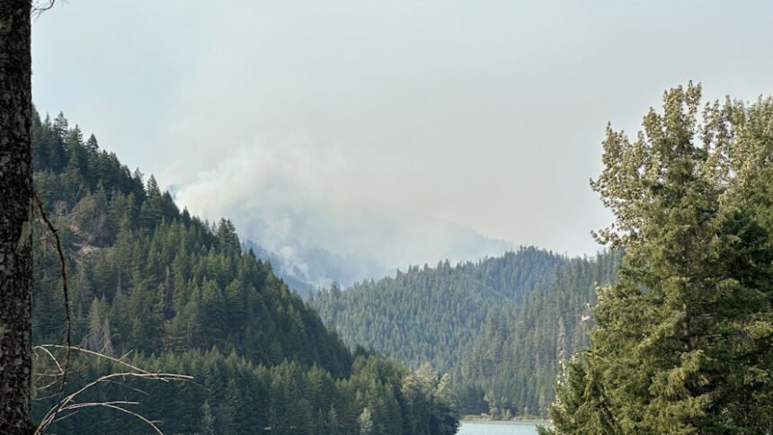
(Springfield, Ore.) – Fire suppression efforts continue on the Ore Fire, which is burning in steep, rugged terrain 7 miles northeast of Blue River, Oregon. The current acreage of 534 is an estimate due to the unavailability of infrared flight. The cause of the fire is under investigation.
In order to minimize risk to firefighting personnel in hazardous terrain, fire managers are implementing containment strategies, such as utilizing existing roads and natural barriers to create containment lines. Firefighters are engaging in activities that will result in a higher probability of success in suppressing the fire while protecting values at risk, such as communities, infrastructure, and forest and cultural resources. The control objectives for this fire include several miles of forest fuel reduction along roads and trails using crews and mechanized equipment. Firefighter and public safety remain the top priority on the Ore Fire.
Yesterday, firefighters removed hazardous trees along the FS 15 road and the fire’s edge. Aerial resources were active, supporting ground crews by monitoring fire progression and assisting with water drops. Heavy machinery, such as masticators and feller bunchers, removed and chipped large trees and vegetation into more manageable material along the FS roads 15, 1509, and 1503. Firefighting efforts were successful in holding the fire north of the FS 15 Road. In addition, crews continued to scout divisions and identify possible control lines utilizing natural barriers and access features.
Today, crews and equipment will build on progress made by continuing work on FS roads 15 and 1509 by thinning and removing fuel from these containment lines. Air operation resources are available and will be utilized to assist personnel as needed and monitor fire progression. Firefighters are also working closely with Resource Advisors to minimize damage to the landscape and cultural resources.
Weather: Near-normal temperatures will move into the area today through the beginning of the week, with highs in the 80s. Relative humidity will increase, and winds will remain terrain-driven over the fire area. A Red Flag Warning is currently in effect until 8 PM for lightning on critically dry areas. The potential for gusty outflow winds in thunderstorm areas could allow for new and existing fires to grow rapidly.
Safety: Fire personnel will be working with heavy equipment along FS Road 15 and 1509. Fire managers ask the public to drive defensively while crews diligently work to complete suppression efforts along the road. Fire restrictions are in place within the Willamette National Forest. Current fire restriction information can be found at: https://www.fs.usda.gov/main/willamette/fire.
Smoke: Smoke from numerous wildfires burning throughout the state will affect air quality in many areas over the coming days. For information on air quality in your area go to: www.airnow.gov.
Forest Closures: Established closures in the Willamette National Forest are in place around fire-impacted areas. These closures include the following sites: Buck Mountain Trail, Tidbits South and West Trail, Gold Hill Trail, Mona Campground, Lookout Campground, and Saddle Dam Boat Launch. For a complete list of recreation and roads in the Ore Fire closure order, visit https://www.fs.usda.gov/alerts/willamette/alerts-notices.
