Central Oregon fires grow fast in hot, windy weather: Crazy Creek Fire doubles to 10,000 acres, new evacuations
(Update: Thursday report)
Here's the Thursday morning report:
Central Oregon Interagency Dispatch Update – July 25, 2024
Central Oregon —Yesterday fire activity increased on the Camp Creek Fire burning 12 miles southwest of Paulina due to afternoon winds. The fire is now estimated at 500 acres and is 0% contained. The fire predominately pushed to the north and is now approximately four miles south of Highway 380. Firefighters on the ground were supported by a very large airtanker, large airtankers, single engine air tankers and air attack. As of last night, the fire was holding along Camp Creek Road on the east side and tankers had dropped fire retardant along the west side.
Yesterday afternoon, the Crook County Sheriff’s Office issued the following: “CCSO Incident Command is on scene at SE Camp Creek Road for the 523 Fire. Strong winds have pushed the fire eastward along SE Camp Creek Road approximately 6 miles south of Paulina Highway. CCSO is placing area residence at LEVEL 2 (BE SET) from SE Camp Creek Road east to Paulina. BLM fire resources are on scene. We ask that you use caution if you are traveling through the area due to the amount of smoke and resources in the area.” For additional updates from the Crook County Sheriff’s Office visit facebook.com/CrookCountySheriff or visit their interactive map: crookcounty.maps.arcgis.com/apps/instant/minimalist/index.html?appid=3ddd30c1faeb455fb287dfa122d9ea5e
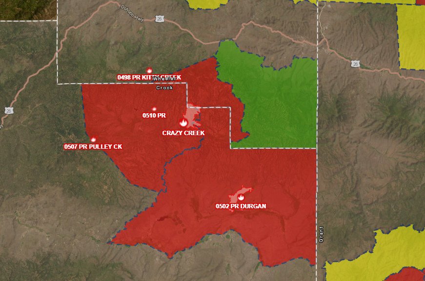
The Durgan Fire, which started on private lands adjacent to the Ochoco National Forest approximately six miles northeast of Paulina was more accurately mapped at 3,200 acres. Firefighters are cooling down hotspots and conducting mop-up operations. Firefighters on scene include Post-Paulina Rangeland Fire Protection Association (RFPA) and federal resources. Federal resources are currently in unified command with the Crook County Emergency Management. The fire is now 85% contained.
On Monday evening, the Crook County Sheriff’s Office shared the following update: “According to incident command at the scene of the fire, the evacuation levels have changed. South of the forest boundary on Beaver Creek Road is now at a level 2 evacuation status. Everything east of Big Summit Prairie to the county line and south to the forest boundary will remain at level 3 evacuation. The roadblock at Ochoco Ranger Station will be removed soon. The roadblock at Beaver Creek Road and Paulina Highway will be moved to the forest boundary.” For additional updates from the Crook County Sheriff’s Office visit facebook.com/CrookCountySheriff or visit their interactive map: crookcounty.maps.arcgis.com/apps/instant/minimalist/index.html?appid=3ddd30c1faeb455fb287dfa122d9ea5e
The Pulley Creek Fire, burning on the Ochoco National Forest, approximately one mile southwest of Big Summit Prairie, remains at 11 acres. Firefighters are continuing mop-up operations and have secured 70 feet interior of the perimeter. Lines continue to hold.
The Round Mountain and Wickiup Fires are burning approximately seven miles northwest of La Pine and just north of Wickiup Reservoir. A Central Oregon Type 3 Team is managing both incidents. Firefighters are continuing to mop up hots spots and secure the perimeters of both fires. The Wickiup Fire remains 168 acres and 70% contained. The Round Mountain Fire remains 108 acres and 25% contained. The Eastern Area Complex Incident Management Team will assume command of these two incidents tomorrow to relieve local resources allowing them to rest and prepare for future initial attack.
Monday the Deschutes County Sheriff’s Office decreased evacuation notices around the Wickiup Fire to Level 1 (Be Ready). This includes the Haner Park area and the Deschutes National Forest between Forest Service Road 4262 and Forest Service Road 44, south of South Century Drive (FS 42) and Burgess Road (FS 43).
The Deschutes National Forest has issued area emergency closures for both the Wickiup Fire and the Round Mountain Fire. Bull Bend and Wyeth Campgrounds and Tenino Boat Launch are currently closed. North Twin Lake Campground remains closed and is being used to support firefighting operations.
Firefighters construct control line around a fire to establish a barrier to keep it from spreading. Containment is based on their confidence that a portion of the fire is secure, and the fire will not move beyond the control line. Firefighters may have control line around the perimeter of a fire, but until they are able to decrease fire activity along the edge of the control line and cool down hotspots, they do not consider that portion of the fire contained.
Visit the official source for wildfire information in Central Oregon at centraloregonfire.org for wildfire updates or follow fire information on X/Twitter @CentralORfire. Call 9-1-1 to report a wildfire.
