Oregon Dept. of Forestry reports over 1 million acres burned; good progress seen on several blazes

(Update: Sunday ODF report)
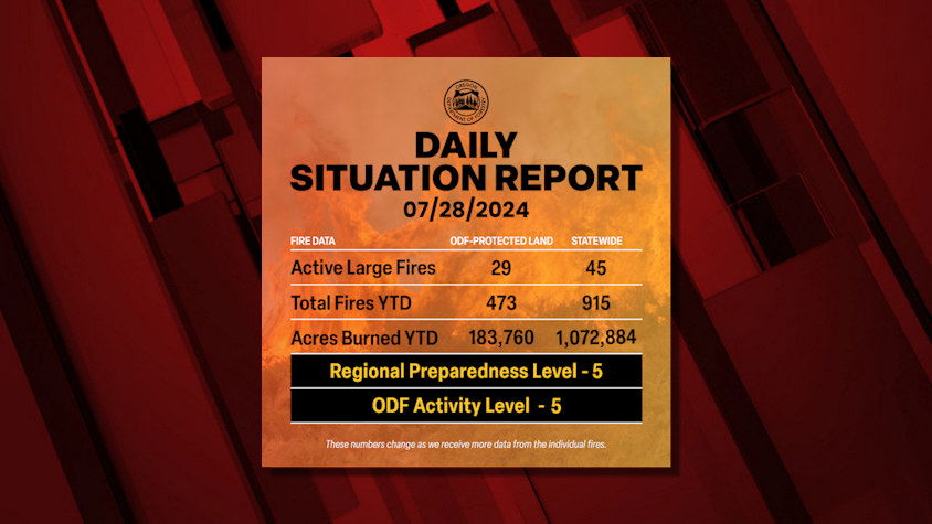
SALEM, Ore. (KTVZ) -- Several of Oregon's largest recent wildfires are at or over 50% containment, thanks to the hard work of thousands of firefighters, while others being tackled are still at zero or in the single digits as the total burned surpasses 1 million acres, the Oregon Department of Forestry said in Sunday's situation update.
Here's the full report.
ODF Incident Management Teams
- Team 1 is in command of the Battle Mountain Complex – Zone 1 and Courtrock fire near Monument (ODF Central Oregon District). Updates available on the incident’s Facebook page.
- Team 3 is in command of the Battle Mountain Complex – Zone 2 near Ukiah (ODF Northeast Oregon District). Governor Kotek has invoked the Emergency Conflagration Act for this fire. Updates available on the incident’s Facebook page.
- North Carolina Forest Service Complex Incident Management Team (CIMT) is in command of the Cottage Grove Complex (ODF South Cascade District). Updates available on the incident’s Facebook page. This team was ordered in by ODF through a state-to-state mutual aid agreement.
- Team 2 is currently on rotation.
ODF Priority Fires
| FIRE NAME | ACRES BURNED (est. acres) | CONTAINMENT | LOCATION | COMMAND |
| Courtrock | 14,496 | 17% | 7 miles South of Monument | ODF IMT 1 |
| Battle Mountain Complex | 162,389 | 7% | West of Ukiah | ODF IMT 1/ ODF IMT 3 |
| Cottage Grove – Lane 1 Fires | 7,327 | 0% | East of Cottage Grove | NC CIMT |
| Durkee | 288,690 | 49% | 5 miles SW of Durkee | CIMT SA Team 3 /OSFM Green Team |
| Falls | 141,989 | 57% | 20 miles NW of Burns | NW Team 8/OSFM Blue Team |
| Microwave | 806 | 53% | 5 miles SW of Mosier | GB Team 6 |
| Cougar Creek | 15,703 | 26% | 35 miles SE of Dayton, WA | CIMT NW Team 13 |
| Pyramid | 1,050 | 8% | 15 miles S of Detroit | CA IMT 5 |
| Slate | 91 | 8% | S of the Detroit Resevoir | CA IMT 5 |
| Crazy Creek | 14,721 | 0% | 16 miles E of Paulina | SW IMT 5 |
| Winding Waters Complex | 565 | 0% | West of Ukiah | Type 3 Team |
There are approximately 9,663 personnel assigned to the 45 large fires across the state, not including many of the local and agency government employees, landowners, forestland operators, and members of the community who are contributing every day.
 ODF Highlight: Oregon is Hawaii’s first deployment under the NW Compact ODF Highlight: Oregon is Hawaii’s first deployment under the NW CompactThis past April, Hawaii became the eleventh member of the Northwest Wildland Fire Protection Agreement (NW Compact). On July 26, Oregon received Michael Walker, State Protection Forester, from Hawaii Division of Forestry & Wildlife to join ODF’s Statewide Support Team. This is the first deployment for Hawaii under the NW Compact. Walker will be serving the team as a Resource Unit Leader.The purpose of the NW Compact is to promote effective prevention, suppression, and control of forest fires in the Northwest wildland region of the United States and Western areas of Canada. It provides an efficient way for member states, provinces, and territories to cope with wildland fires that might be beyond the capabilities of a single member agency, through information sharing, technology and resource distribution. Weather Westerly general winds will continue today along the east slopes of the Cascades and through the terrain gaps. These will pick up on Monday. Isolated thunderstorms are possible today over southeast Oregon and possibly over northeastern Washington. Temperatures will continue to be slightly below normal today through Monday. Prevention As firefighters take advantage of more favorable weather conditions, make sure you’re not adding another fire to their tasks. Keep up on your fire prevention and learn more at www.keeporegongreen.org. Please, know the fire danger level of the areas where you live, work and play, and follow all local restrictions on burning, equipment use, campfires and other activities that can start wildfires. Find danger levels and restrictions across the state here. Resources ODF wildfire blog and Public Fire Restrictions/Danger Levels mapRegional situation report and national situation reportInciweb (information, photos, videos, and maps from specific incidents) |