Crazy Creek Fire keeps growing within its perimeter, now over 86,000 acres; containment increases to 63%
(Update: Tuesday report on more acres burned, containment increase)
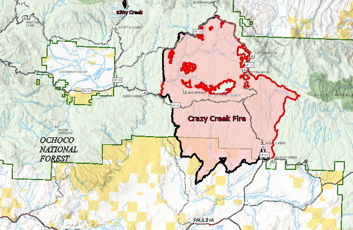
PAULINA, Ore. (KTVZ) -- The over 3-week-old Crazy Creek Fire has grown to over 86,600 acres in Crook and Wheeler counties, but that's all interior burning, as the perimeter has been holding and the blaze is now 63% contained, officials said Tuesday.
Here's Tuesday's update:
Cooling temperatures and higher humidities improve conditions for containment
Daily Update August 13, 2024
Fire Information Phone: 541-208-1768 (8 a.m.-8 p.m.)
Email: 2024.crazycreek@firenet.gov
Acres*: Crazy Creek – 86,603; 63% contained Kitty Creek – 73; 100% contained
*Acreage changes may occur due to overnight operations and infrared mapping.
Location: Crazy Creek: 5 miles north of Paulina, Oregon; 498/Kitty Creek: 7 miles south of Mitchell, Oregon
Start Date: July 22, 2024 Personnel: 739
Resources: 20 crews | 1 helicopter | 39 engines | 12 bulldozers | 19 water tenders | 3 masticators | 37 skid steers
Highlights: On Monday, interior pockets of fuel continued to burn within the Crazy Creek Fire, though the fire perimeter continues to remain the same. The Crazy Creek Fire increased by 2,091 acres burned to 86,603 total acres. Firefighters successfully held problem areas in check. The fire is now 63 percent contained.
Changing weather conditions such as slightly cooler temperatures and slightly higher relative humidities created improved conditions for containment yesterday. This trend is expected to continue for the next several days.
Firing operations and yesterday’s increased fire activity accomplished a lot in reducing the size of the interior islands. The fire activity is active along the northeast side of the fire in Little Summit, Wolf, and East Wolf Creek. Active fire behavior is expected to continue over the next several days with potential spotting over containment lines. Firefighters will continue to patrol for the threat of spot fires outside of control lines.
An overnight flyover of the Kitty Creek Fire confirmed that it is out.
Evacuations: Crook County Sherriff’s Office has lowered the evacuation level to Level 2 for the area of Highway 380 north to SE Puett Road. The area north of SE Puett Road around the perimeter of the fire is still at Level 3. The area south of Highway 380 is now lowered to Level 1. Please review the Crook County Office of Emergency Management evacuation map for further details.
Weather: Slightly cooler weather is forecasted over the next couple of days with high temperatures in the 80s, low relative humidities, partly cloudy skies, and light wind gusts of up to 20 mph in the afternoon.
Importance of Fire Prevention: All public lands in Central Oregon, including the Ochoco National Forest, are in Stage 2 Public Use (Fire) Restrictions. All open flames, including woodstoves and charcoal briquette fires, are prohibited. In times of high fire danger, it is crucial for everyone to follow prevention measures to avoid additional strain on overburdened resources.
Fire Restrictions and Closures: The Ochoco National Forest has implemented a forest closure for the Paulina Ranger District. The Bureau of Land Management has issued a temporary closure for public lands in Crook and Grant counties.
More Information:
InciWeb: https://inciweb.wildfire.gov/incident-information/orocf-crazy-creek
Facebook: Facebook.com/Crazy Creek Fire
Central Oregon Wildfire Information: https://centraloregonfire.org/
Crook County Emergency Information Map: https://arcg.is/1ij0vb
