A still-warm, still-dry early fall means C.O. fires are still putting up smoke, but containment also growing
Bachelor Complex at 68%; Rail Ridge 'tactical firing operations' to put up more smoke this week
BEND, Ore. (KTVZ) – The Bachelor Complex of fires, primarily the Little Lava Fire, grew some over the weekend, totaling 12,536 acres, but containment also grew to 68% by the 70 personnel on the lines, despite the recent warm and windy conditions at times.
Central Oregon fire officials shared photos Sunday of firefighters hiking along the Edison No. 3 Trail on the northern flank of the Little Lava Fire as the work to reduce fuels and prepare the trail as a control feature to keep the fire from growing to the east.
“The Little Lava Fire is expected to continue burning slowly north with low to moderate intensity with the current mild, warm weather conditions,” a Deschutes National Forest update said Sunday.
Meanwhile, near Crescent Lake, about the same number of firefighters (74) have brought toe 2,817-acre Red Cire to 15% containment.
Officials said strategic burn operations near Greenwood Point were successful Saturday in eliminating unburned fuels between the fire and control lines, protecting cabins to the east.
The fire is expected to continue creeping and backing to the east along Forest Service Road 60.
Here are Sunday's other fire updates:
Favorable weather moderates Bingham Fire growth
Daily Update: October 6, 2024
Fire Information Phone: 503-854-3366 (8 a.m.-8 p.m.)
Email: 2024.Bingham@firenet.gov
Acres: 183 Containment: 0%
Location: Areas of the Mount Jefferson Wilderness, east of Marion Forks.
Start Date: September 30,2024 Personnel: 251
Resources: 10 crews | 10 engines | 2 bulldozers |
Highlights: The Bingham Fire saw minimal growth as cooler temperatures and low wind speeds kept the fire at its existing 183 acres. California Incident Management Team 1, under the direction of incident commander John Goss, assumed management of the fire at 6 a.m. today.
Firefighters worked throughout the day building containment lines around the fire’s perimeter. Particular attention was given to the fire’s northwest corner, where an enclave of summer homes and a fish hatchery lie about 2 miles from the fire’s perimeter. A crew of firefighters have been stationed near the structures to begin constructing contingency containment lines in the event the fire escapes its current perimeter.
While fire behavior has been tempered by weather in the mid-60s and winds mostly less than 5 miles an hour the last two days, temperatures are forecasted to climb into the upper 70s today and into the 80s Monday. Winds are expected to remain relatively calm, up to 5 to 10 miles an hour.
Evacuations: LEVEL 3: GO NOW! Evacuation alerts have been issued by the Linn County Sheriff’s Office for a large area of the Mount Jefferson Wilderness. Additionally, LEVEL 2: GET SET evacuation alerts have been issued for the area around Marion Forks Campground and Marion Forks Fish Hatchery. The Level 2 evacuation area also extends along Highway 22, to a ½-mile west of Highway 22, from Pamelia Road (NFS Road 2246) south to Parrish Lake Road (NFS Road 2266). Please refer to the Linn County Wildfire Map for more information: https://tinyurl.com/LinnCoFireMap. Highway 22 remains open at this time.
The Willamette National Forest issued an updated formal closure yesterday in the same footprint of the Level 3 Evacuation here: https://tinyurl.com/26jpr9a6. A large evacuation area like this is necessary to give wildfire response teams enough space to safely travel to and fight the fire as crews will be on road systems and trails and air assets may be utilizing nearby water sources. The fire itself is much smaller than the evacuation area. The Pacific Crest Trail through the Mount Jefferson Wilderness is expected to remain open. The trails and roads west of the highway are closed from Pamelia to Big Meadows Loop/Turpentine Loop area. Hunting season will be opening today, and the forest will work with Linn County Sheriff to reduce closure areas as soon as it is safe to do so.
Weather: Mild and dry conditions with light winds are expected. Temperatures are forecasted to climb into the low 80s by Monday, but falling back into the 60s on Tuesday. A 10 percent chance of rain is expected by Tuesday or Wednesday.
--
Rail Ridge Fire Update
October 06, 2024
Central Oregon Wildfire Information: centraloregonfire.org
Email: 2024.railridge@firenet.gov – Phone: 541-208-7111
Social Media, Evacuation and Closure Information: https://linktr.ee/RailRidgeFire
(Link Tree appears to be down, but more info can be found at: https://inciweb.wildfire.gov/incident-information/orocf-rail-ridge
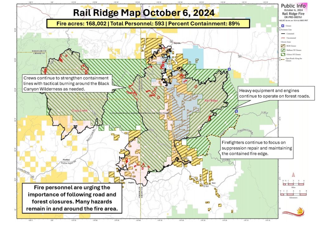
Acres: 168,002 – Containment: 89% – Detection: 09/02/24 – Cause: Lightning – Personnel: 593
Forest closures are still in place and hazardous conditions remain within the fire area. Hazards include:
- Narrow, damaged, one-way roads
- Changing and unexpected fire behavior
- Hazard trees
- Unstable ground that has recently been burned
- Heavy equipment, vehicles, and crews on the roads
It is critical for the safety of forest visitors and fire personnel that no unauthorized people enter the fire area. Information including updates on the Rail Ridge Fire, the forest closure order, and a map with ODFW hunting management areas overlayed with the closure area and fire footprint can be found at https://linktr.ee/RailRidgeFire.
Operational Update
Yesterday, smoke was visible in the area as fuels continue to burn on the interior of the fire. Crews performed tactical firing operations to strengthen the dozer and hand lines around the active fire in the Black Canyon Wilderness. Firefighters worked diligently on protecting the communications site and lookout tower on Wolf Mountain. Yesterday’s firing operations helped secure that site. Suppression Repair work and mop-up continued around the fire.
Today, firefighters will be focusing on suppression repair and maintaining the perimeter along the edge of much of the fire. A slight afternoon increase in winds may cause some increased fire activity in the Black Canyon Wilderness area. Crews will continue to strengthen the perimeter and perform tactical firing operations as needed.
Weather will continue to be seasonably warm, although the shorter days and higher relative humidity that come with early October will be shortening the afternoon burn period. Suppression repair remains a focus for the incident management team, and fire crews based out of both the Rager and Dayville fire camps will continue this important work.
Patrolling of the uncontained areas around the northern edge of the fire and mop-up of any heat found along the contained fire edge will continue. Air resources remain available to firefighters as needed.
Weather: Above seasonally normal temperatures in the low to mid 70s are expected with dry conditions due to lower relative humidity than the last few days. Afternoon winds are expected with possible gusts up to 20mph.
Evacuations: Level 1 evacuations in Grant County were dropped this week and the Level 2 evacuations remain. Wheeler County evacuations remain the same.
For Current Evacuation Levels all affected counties, please visit: https://linktr.ee/RailRidgeFire
Closures: The U.S. Forest Service and Bureau of Land Management have implemented closures for the Rail Ridge Fire. For more details and closure maps, visit https://linktr.ee/RailRidgeFire
--
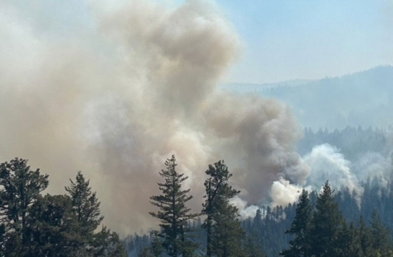
Public Should Expect an Increase in Smoke From the Rail Ridge Fire, Officials Say
Tactical firing operations over the next several days in the Black Canyon Wilderness will produce a short-term increase in smoke.
The operations, which will start October 7, will allow fire crews to focus suppression activities on the last actively burning section of the Rail Ridge Fire. Without these actions, the uncontained fire in the Black Canyon Wilderness will continue to burn until a fire-season ending weather event occurs. Current weather predictions show no such event forecasted in the next two weeks. With consideration of wind patterns and weather, an increase in smoke is expected to the northeast of the fire, potentially impacting Dayville and Mount Vernon and possibly John Day.
Firefighters have been using small firing operations to stay ahead of the fire growth as the fire moves out of the steep canyons west of the South Fork John Day River. Fire personnel have determined the best course of action at this time is to perform further tactical firing operations, much like a prescribed burn would be implemented this time of year. The prescribed firing operations provide for an opportunity for mild, healthy fire effects throughout the wilderness and shorten the duration of having uncontained fire on the landscape.
The plan will create additional smoke in the area but for a reduced amount of time. The shorter timeline will also help limit costs of the firefighting effort, keep firefighters safer and require less resources when the fire is returned back to the local unit to manage. “We want to help local communities and land owners get back to normal.” says Rail Ridge Incident Commander Brian Ebert. “Extreme fire behavior is unlikely this time of year, and weather conditions are favorable to complete the remaining five miles of open line along the Northwest edge of the fire. The intent is to provide some much-anticipated relief to those who live nearby.”
In areas very close to the fire, there will likely be a higher smoke impact at night and in the morning due to inversion. Forest visitors should be keeping their distance from the fire area by following forest closures. For more information about the closures, including a map with the ODFW hunting management unit areas overlaid with the closure area and fire footprint can be found at: https://linktr.ee/RailRidgeFire. Visitors coming to hunt in the area should be sure to check closures to know where camping and hunting is allowed.