Snowstorm, blizzard move into Cascades, C. Oregon; COCC closed at noon, OSU-Cascades, courts at 4 p.m.
(Update: Winter storm warning, more snow predicted; OSU-Cascades, courts closing at 4 pm)
BEND, Ore. (KTVZ) – The first surge of a major winter storm that’s expected to bring blizzard conditions in the Cascades and some areas of the High Desert moved in Tuesday morning, making for widespread travel trouble and prompting Central Oregon Community College to close its campuses at midday and OSU-Cascades in the late afternoon.
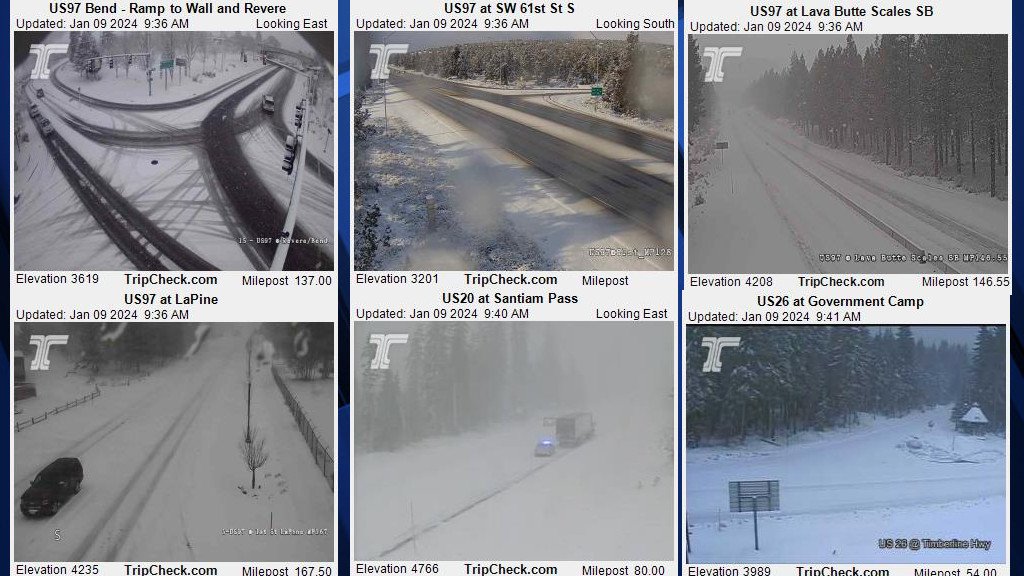
In Bend, overnight rain turned to heavy, wet snow around daybreak, piling up an inch or two in a couple of hours before sun and blue skies appeared in a mid-morning storm break. There were reports of stuck semi- and delivery trucks, slide-offs and scanner reports of “almost a complete whiteout” in places.
The National Weather Service issued a winter storm warning for Central Oregon around noon, warning of more heavy snow, with 2-5 more inches Tuesday night, total storm accumulations of 4-8 inches and winds gusting up to 40 mph, later increased to 50 mph But the NWS also said Bend could see 5-9 more inches Tuesday night.
Due to weather and road conditions, all COCC campuses closed at noon Tuesday. All classes and events are canceled, including remote/online classes. The closure impacts both on-campus and remote personnel. For more information, go to https://www.cocc.edu/emergency.
If members of the community are interested in receiving COCC Alert, the college's emergency notifications, they can follow the sign-up instructions online.
Meanwhile, OSU-Cascades decided by early afternoon that the Bend campus will close at 4 p.m. due to the snowstorm in the region.
Students were advised to check Canvas for information about affected classes. Students and employees were advised to exercise caution on their commute home. For more information, visit OSUcascades.edu or call 541-322-3100.
Deschutes County Circuit Courts also announced they were closing early, at 4 p.m.
The snowfall, though forecast and not a surprise, also affected other activities, prompting a 10-day delay in the ribbon-cutting of the Rooted at Poplar workforce housing development in southwest Bend. (Please let us know about any weather-related cancellations or delays at stories@ktvz.com.)
NWS forecasters in Pendleton said in their mid-morning discussion that the cold front which swept across the region Tuesday morning brought very gusty winds and heavy mountain snow. Another round of strong winds and precipitation is expected in the evening as a “secondary low” tracks across the northern part of the state.
A blizzard warning remains in effect until 4 p.m. Wednesday for the east slopes of the Cascades, including La Pine and Sunriver, with total snow accumulations of 10-36 inches and winds gusting as high as 60 mph, meaning “very difficult to impossible” travel. Motorists were still urged to only travel in emergencies.
In the northern Cascades, “dangerous blizzard conditions” were expected, with white-out conditions at times and 1-4 feet of snow expected, heaviest above 3,000 feet, and southwest to west winds gusting to 55 mph at pass levels and as high as 75 mph for ski resort elevations. A winter storm warning was in effect above 1,500 feet and blizzard warning over 3,000 feet.
Tuesday morning's ODOT update:
Winter is hitting Oregon hard this week with snow, high winds and cold in many parts of the state.
The National Oceanic and Atmospheric Administration (NOAA) sees the first severe storms of the season with blizzard conditions including near zero visibility starting today.
Last night, I-84 in eastern Oregon saw multiple closures for crashes and spun-out vehicles that struggled to gain traction on snowy roads.
U.S 97 is snow covered from Redmond south to the border with California and blizzard conditions are due to hit the corridor south of Bend.
All mountain passes, both high and low elevation, are already seeing the impacts of this storm. High winds combined with heavy precipitation will cause travel impacts. Expect to encounter chain restrictions if traveling these areas and plan extra time for your journey if you decide to travel. Delays and closures are common during storms of this magnitude.
The Portland area may get some light snow Tuesday night or Wednesday morning. Be prepared to drive in the snow and make sure you have a capable vehicle to get you where you need to go. Remember that public transportation can be a good option.
Tripcheck.com has real time updates for conditions happening on the roads. It is the public facing view of our 24/7 staffed dispatch centers that monitor all state roads.
No matter where you are in Oregon, prepare for challenging conditions in the days to come. Stay home if you can or plan ahead and prepare if you have to travel. We want everyone to get where they need to go safely.
For even more winter weather driving tips, see ODOT's winter travel news packet.
