NWS confirms destructive SE Oregon, western Idaho storm was a microburst
BOISE, Idaho (KTVB) — The Nyssa, Oregon community faces the aftermath of a confirmed microburst that tore through their community Wednesday afternoon. KTVB was on the scene and residents said that the storm felt like a tornado or hurricane.
The National Weather Service in Boise confirmed on Thursday that the weather event in southeast Oregon an western Idaho was a wet microburst produced by a supercell thunderstorm, after sending a team to the area to evaluate the damage.
While the damage was significant, the community banded together to help their fellow neighbors.
Nyssa Police Chief Don Ballou said he loves his community because it has come together to help each other and repair what was broken.
"One thing I love about this Nyssa community is when things like this happen, they come out," Ballou said.
Ballou said he was also helping with cleanup efforts on Thursday.
"I was out there yesterday, trimming trees and doing everything everyone else was doing," Ballou said.
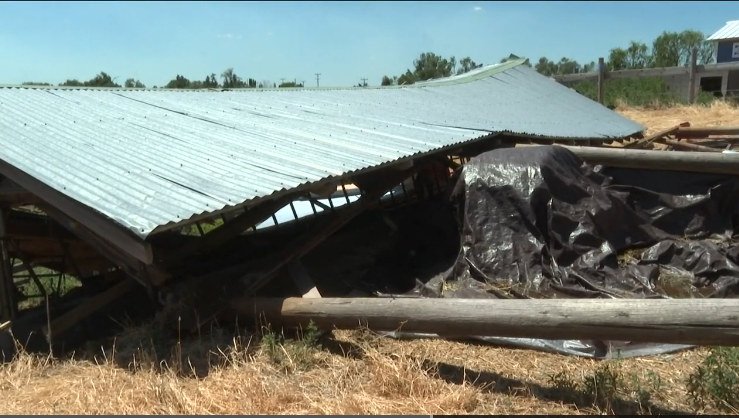
The NWS report revealed the damage is consistent with a wet microburst. The storm's powerful straight-line winds flattened wheat and corn crops, ripped aluminum siding off outbuildings and flipped over a small shed and a camper. Ten power poles were shattered at their bases, but they had already been replaced at the time of the survey.
"A house was reported to have a window shattered, and the rapid increase in pressure inside the house caused a crawlspace door to shoot upwards and for trusses to be broken. One barn had its doors ripped off by the wind," NWS stated in its investigation.
One person said they broke their arm when flying debris hit them, this person believed the debris was a tree limb, according to NWS.
NWS determined the storm's maximum wind gusts were around 75-80 mph (which means winds briefly reached the strength of a category 1 hurricane) (Additional note: hurricane strength is based on sustained wind speeds and not wind gusts but in this case it's unclear exactly how long the strong winds with this storm lasted). There were also hailstones an inch in diameter that battered and shredded one cornfield and exposed the heads of onion fields.
NWS said they also saw minor flooding during their survey and during the storm, water was about six feet deep in the East Main Street railroad underpass.
Of the areas the NWS surveyed, they found the most significant damage was to the west of Parma, areas south and east of the storm.
For those in the Nyssa community, the power was out for 12 hours before it was restored. Several trees are still overhanging homes in South Park and at Nyssa Elementary School, but the roads are all open and clear of flooding.
Residents said they are now hiring contractors to give them estimates on rebuilding, clearing trees and cleaning up from the disaster.
