Lionshead Fire grows to nearly 19,000 acres as area closures expand
(Update: Willamette National Forest expands wilderness closure after 'relatively quiet day ... minimal growth')
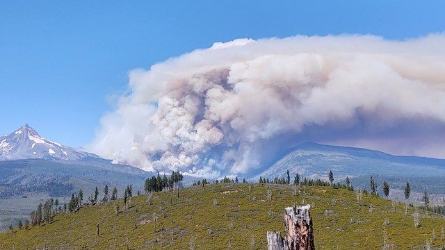
Strong winds, extreme fire behavior could pose major test on Monday
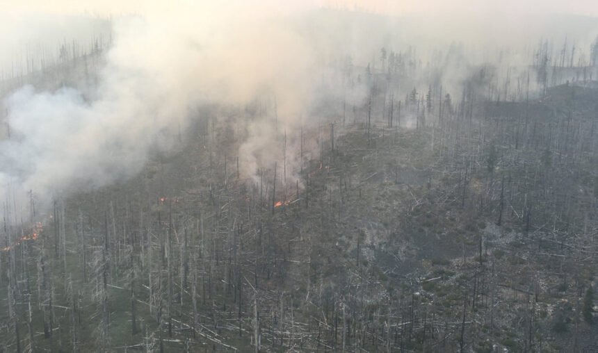
WARM SPRINGS, Ore. (KTVZ) -- The Lionshead Fire on the Warm Springs Indian Reservation grew to nearly 19,000 acres by Monday, prompting closure of most of the Mount Jefferson Wilderness Area, trail and campground closures on three national forests and pre-evacuation notices in the Camp Sherman area.
On Sunday night, fire managers called it "a relatively quiet day, with minimal growth on the fire line." But officials said it still grow by roughly 2,000 acres, to 18,615 acres, by Monday morning
"The fire area was either shaded by the smoke or covered by an inversion which never lifted," officials said.
However, they warned, the red flag warning for strong winds Monday afternoon "could be very challenging for firefighters and managers."
Late Sunday night, the Willamette National Forest issued a news release expanding its Mount Jefferson Wilderness Area closure:
Lionshead Fire to temporarily close Mt. Jefferson Wilderness and adjacent national forest lands
Springfield, OR, Sept. 6, 2020 – Fire managers warn that the Lionshead Fire is exhibiting active behavior on the Warm Springs Reservation and Deschutes National Forest that could soon spread onto the Willamette National Forest. To uphold public safety as the highest priority, the Willamette National Forest is preparing an expanded closure order in the Mt. Jefferson Wilderness west to Oregon Highway 22 and south to U.S. Highway 20.
“We are ramping up our closure to ensure folks stay clear of the area during the next 72 hours,” said Willamette Forest Supervisor David Warnack. “We plan to shrink the closure as appropriate, once we see how the fire behaves with anticipated high wind gusts during these next few days.”
For public safety, Detroit wilderness rangers, alongside Linn and Marion county sheriff's deputies,, are working together to notify visitors in the area encompassed by the expanded closure order.
Over these next few days, the combination of high winds at 15-30 mph from the east with gusts up to 50 mph, low humidity and dry fuels could cause rapid fire spread. A red flag warning is in effect for wind and low humidity through Wednesday evening.
The forest urged people to please observe public use restrictions and help us limit potential new starts during this time.
“The fire weather forecast is extremely rare and occurs only a few times a century,” said Eric Johnson, deputy fire staff for Northwest Oregon Fire Management. “Any new fires will prove challenging to suppress, so please help firefighters by not doing activities that could create sparks.”
Visit: https://inciweb.nwcg.gov/incident/7049/ for more information on the Lionshead Fire. Visit: https://go.usa.gov/xGDq5 to view the forthcoming closure. Visit: https://www.fs.usda.gov/main/willamette/fire for a list of personal use restrictions and to find fire closure orders and follow us on Facebook and Twitter @WillametteNF.
Meanwhile, the Oregon Department of Environmental Quality issued a new air quality advisory late Sunday for areas of Southern and Central Oregon due to smoke, including Deschutes County through Monday night due to smoke from the Lionshead Fire.
Sisters had risen to the "unhealthy" category for air pollution Sunday night, while the rest of the area was in the "moderate" category, according to the DEQ's Air Quality Index.
Here is the full text of a broader area closure on the Deschutes National Forest, announced Sunday afternoon. The map can be found at: https://www.fs.usda.gov/Internet/FSE_DOCUMENTS/fseprd798764.pdf
Deschutes National Forest Officials Increase Area Closure Due to Lionshead Fire
New closure area includes portion of Metolius Basin
Sisters, Ore.- Effective immediately, the Sisters Ranger District on the Deschutes National Forest is implementing an increased area closure due to the Lionshead Fire’s very active fire behavior.
The closure area boundaries are as follows (see map for more information):
Northern Closure Boundary
From the boundary between the Willamette National Forest, the Deschutes National Forest, and the Warm Springs Indian Reservation (T 11S, R 8E, Section 5) near Goat Peak, heading east and including all lands south of Warm Springs Indian Reservation boundary, to the intersection of Forest System Road (FSR) 1400 (T 11S, R 9E, Section 35)
Eastern Closure Boundary
From the junction of the Warm Springs Indian Reservations and FSR 1400 (T 11S, R 9E, Section 35) south along FSR 1400 including FSR 1400, all lands west of FSR 1400 to the intersection of FSR 1247 (T 13S, R 9E, Section 3)
Southern Closure Boundary
From the intersection of FSR 1400 and FSR 1217 (T 13S, R 9E, Section 3) heading west and all lands north of FSR 1247 including FSR 1247, to the junction FSR 1247 with FSR 1200 (T 13S, R 9E, Section 7) then north on FSR 1200 to the junction of FSR 1220, then heading west and all lands north of FSR 1220 including 1220 to the northern boundary of Section 4 (T 13S, R 0E), then heading west and all lands north of the Section 4 boundary to the Willamette National Forest (T 12S, R 7E, Section 36)
Western Closure Boundary
From the intersection of the northern boundary of Section 4 (T 13S, R 0E) with the Willamette National Forest boundary, south of Three Finger Jack including all lands east of the Willamette National Forest boundary including the Pacific Crest trail 2000 until the junction of the Willamette National Forest boundary, Deschutes National Forest boundary, and Warm Springs Indian Reservation boundary (T 11S, R 8E, Section 5)
Campgrounds
Within this closure area, the following campgrounds are now closed: Candle Creek, Lower Bridge, Pioneer Ford, Allen Springs, Canyon Creek, Lower Canyon Creek, Gorge, Pine Rest, Smiling River, Jack Creek, Jack Lake, Abbot Creek and Sheep Springs Horse Camp.
Developed Recreation Sites
The following developed recreation sites are now closed: Jefferson Lake Trailhead, Cabot Lake Trailhead, Brush Creek Trailhead, Bear Valley Trailhead, Rock Pile Lake Trailhead, Jack Lake Trailhead, Head of Jack Creek Trailhead and Lower Bridge Picnic Area.
Trails
In addition to all trails within the closure area, the following trails are also closed: Old Summit trail 4014 north of Booth Lake (T 13S, R 8 E, Section 7), Shut In trail 4019 and the Pacific Crest Trail for the entire length within the Mount Jefferson Wilderness on the Deschutes National Forest.
Roads
All roads within the closure area are closed, including: FSR 1490 from the junction of FSR 1400 to the junction with FSR 1140, FSR 1400 north from the junction with FSR 1120 to the junction with FSR 1499, FSR 1499, FSR 6400 (SW Montgomery Road) from trail 4019 to the Monty Campground, FSR 1217, FSR 1200 from the junction of FSR 1217 to the north and FSR 1220.
Visitors should abide by this closure to avoid potential injury and create unnecessary risk to others. The closure will remain in place until the wildfire is no longer a threat to these areas.
Individuals concerned about the large smoke column in the Sisters and Camp Sherman area should be assured that the Green Ridge Fire remains 100% contained and all smoke is from the Lionshead Fire.
For information on the Lionshead Fire, please go to https://inciweb.nwcg.gov/incident/7049/ .
Area closures, including 40 miles of the Pacific Crest Trail, and Jefferson County's Level 1 and 2 evacuation notes were announced on Saturday.
Here's Sunday morning's update on the Warm Springs fires, along with the Beachie Creek Fire north of Detroit and extreme fire danger in northwest Oregon forests:
Quick Facts
Incident Summaries
P-515 / Lionshead
Approximate Size
in acres: 4,609 ac./
15,945 ac.
Fire Containment: 95% / 31%
Incident
Commander: Alan Lawson
Resources on the
Fires:
Crews: 17
Helicopters: 4
Engines: 20
Water Tenders: 23
Dozers: 7
Masticator: 5
Skidgen: 5
Total Personnel: 611
Jurisdiction:
Confederated Tribes
of Warm Springs
Oregon Smoke Blog
http://oregonsmoke.blogspot.com/
Facebook
https://www.facebook.com/KWSOnews
https://www.facebook.com/northwestteam10/
Inciweb
https://inciweb.nwcg.gov/incident/7050/
https://inciweb.nwcg.gov/incident/7049/
Sunday, September 6, 2020
Incident Commander: Alan Lawson, Northwest Team 10
E-mail – 2020.p515@firenet.gov
Fire Information: 971-277-5075
Warm Springs, Oregon - This update is for the P-515 and Lionshead Fires, burning on the Warm Springs Reservation. Both fires are being managed for full suppression.
Current Status: The perimeter of the P-515 Fire is completely lined. Hand crews continue to improve containment lines and mop up is ongoing in close coordination with resource advisors. Back haul of excess equipment is being facilitated and resources are being incorporated with the Lionshead Fire.
The Lionshead Fire burned actively yesterday and is now 15,945 acres and 31% contained. The fire spotted approximately 2 miles to the north into the Shitike Drainage. The fire also made a push to the southwest, then hooked back to the east, crossing Bald Peter. Air resources worked the edges of the fire, giving firefighters time to continue to assess potential containment options along the fire’s perimeter.
Today’s Operations: Ground crews will continue to assess potential opportunities for indirect containment options along the P-400 Road to the north and the J-140 Road to the south. Low relative humidity, high temperatures, and dry conditions will lead to continued extremely active fire behavior throughout the day. A strong low-level inversion will limit air support through most of the day. Crews will continue to mop up along all secure containment lines and spot fires.
Weather and Fire Behavior: With abundant dry fuels and both daytime and nighttime humidity values that continue to be very low, extremely active fire behavior is expected again today. Winds on Sunday will be light and variable, followed by a cold front on Monday moving from north to south with wind gusts expected to be 35-40 mph from the east-northeast. A fire weather watch is in effect for gusty winds and low humidity Monday and Tuesday.
Closures: For public and firefighter safety, roads and trails on the southwest portion of the Warm Springs Reservation near the fires are closed to the public. Deschutes National Forest and Willamette National Forest are closing much of the Mt. Jefferson Wilderness. Forty miles of the Pacific Crest Trail are closed between Santiam Pass and Olallie Lake. Mt. Hood National Forest has closed the Olallie Lake and Breitenbush Lake area. Allingham Campground and campgrounds to the north are now closed. See Willamette, Deschutes, and Mt. Hood N.F. websites for trail and area closures.
A Temporary Flight Restriction is in place over the P-515 and Lionshead Fires. Wildfires are a No Drone Zone.
Evacuations: Orders are being issued for evacuations as conditions change. Please monitor the sheriff’s department and National Forest websites and Facebook pages for updates.
www.fs.usda.gov/deschutes/
www.fs.usda.gov/willamette/
www.fs.usda.gov/mthood/
www.facebook.com/DeschutesCountySheriff/
www.facebook.com/JeffersonCountyORSheriff/ www.facebook.com/LinnSheriff/
www.facebook.com/MCSOInTheKnow/
COVID-19: NW Team 10 is following recommendations from the Centers for Disease Control and Prevention to keep fire personnel and the public safe. There is no public access to the Incident Command Post at the Jefferson Co. Fairgrounds.
Prevention Message: National Preparedness Month is recognized each September to promote family and community disaster planning, now and throughout the year! Learn more here: https://www.ready.gov/september
---
Beachie Creek Fire update, Sunday, Sept. 6:
Brian Gales, Incident Commander Lonnie Click, Deputy IC
| Start date: Aug, 16, 2020 | Location: Opal Creek wilderness, 6 mi North of Detroit, OR | Cause: Unknown |
| Fire size: 425 Acres | Helicopters Assigned: 4 | Total personnel: 153 |
Gates, Ore. – Fire officials continue to be fully engaged with the Beachie Creek Fire, located within the Willamette National Forest, six miles north of the community of Detroit. The fire is currently confined to the Opal Creek Wilderness, and is burning in heavy timber on inaccessible, steep slopes.
Firefighting efforts today will be a continuation of keeping the fire in its current location utilizing aviation firefighting resources with water delivery. Indirect fire line opportunities are also being identified where possible. Forest roads will be improved for firefighter access and containment lines should the fire come out of its current location. This includes identifying hazardous trees for removal in anticipation of the upcoming wind event.
WEATHER: Critical fire weather conditions are expected to develop Monday and persist through Wednesday night. In addition, an unseasonably strong offshore flow event is expected to bring extremely dry and windy conditions to the area. A Fire Red Flag warning is also expected to be issued by the weather service for Monday afternoon through Wednesday evening.
SAFETY: The Marion County Sheriff’s Office is asking the public to be aware of aerial firefighting aircraft, CL-415 scoopers that will be scooping water directly from Detroit Lake in support of firefighting efforts on the Beachie Creek Fire. The area of the lake south of Piety Island will be closed during daylight operational hours until further notice, starting today at 10 am. In addition, the following campgrounds will be impacted and will not be accessible by boat during there hours; Cove Creek Campground, Sportsman Campground and South Shore Campground. The closure will likely extend through the next two to three days. Marion County Sheriff’s Office will have officers in boats patrolling the closed area.
RESTRICTIONS:
Campfires are restricted to developed campsites in Forest Service provided fire rings. Never leave a campfire unattended. Drown it with water, stir it thoroughly, and feel it with your hand to ensure that it is out cold. Fires are only allowed in designated campgrounds. (Order 06-18-00-20-16).
CLOSURES: Willamette National Forest roads, trails, and lands around the fire area are closed. View the official order (Order 06-18-04-20-13) or go to InciWeb (link below) for a list and map of the closed, roads, trails, and recreation sites.
| Public information: Facebook: @WillametteNF@WillametteNF Twitter: @WillametteNF E-mail: 2020.beachiecreek@firenet.gov Phone: 541-583-0526, 8 a.m. to 8 p.m. | Inciweb https://inciweb.nwcg.gov/incident/7001/ Oregon Smoke Blog http://oregonsmoke.blogspot.com/p/air-quality-now.html |
State forests in NW Oregon moving to extreme fire danger; additional public use restrictions in place
Oregon Dept. of Forestry - 09/06/20 11:15 AM
SALEM, Ore. — With a Red Flag Warning in the forecast, state-managed forests in northwest Oregon will be in Extreme Fire Danger as of Monday morning. Campers are encouraged to leave during that time, and visitors should consider delaying their trip until fire danger moderates. Strong winds, high temperatures and dry conditions are predicted early in the week.
Starting Monday, visitors to state-managed forests in northwest Oregon can expect more public use restrictions, such as a ban on off-highway vehicle use, limited or no campfire opportunities, and more forest roads closed to vehicle traffic. This includes the Tillamook, Clatsop and Santiam state forests as well as smaller tracts of state forestland in Polk, Lincoln, Benton, and Columbia counties. Restrictions specific to a particular area can be found on the ODF website at https://www.oregon.gov/odf/fire/pages/restrictions.aspx.
The National Weather Service has issued a Red Flag Warning for northwest Oregon and southwest Washington starting 11 a.m. Monday through 8 p.m. Wednesday, indicating critical fire conditions. The NWS is predicting a strong east wind event starting Monday and continuing through at least Tuesday night. East winds and dry conditions in late summer historically have resulted in some of northwest Oregon’s largest wildfires. If possible, the Oregon Department of Forestry recommends that visitors delay their trip to state forests until these conditions subside, likely later in the week.
Precautions such as these can prevent most wildfires:
- Check current fire restrictions for the area before visiting: Restrictions on activities such as building campfires and riding off-highway vehicles are often in place in cases of extreme fire danger.
- Check your vehicle for dragging tow chains that can send sparks into roadside vegetation.
- Don’t park or idle on dry grass or brush – the hot exhaust system can set it smoldering in seconds.
- Smoke only in an enclosed vehicle. Properly dispose of cigarette butts.
- If you see smoke, call 911.
- Always have fire extinguishing tools on hand.
