Guard soldiers arrive on growing wildfire near John Day

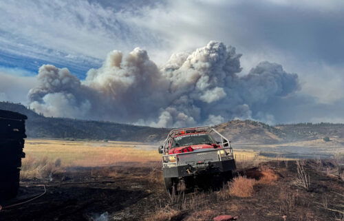
JOHN DAY, Ore. (AP — National Guard soldiers newly trained as firefighters have started arriving at fire camp in Eastern Oregon to help mop up a blaze that destroyed more than three dozen homes and burned through more than 115 square miles.
Fire spokeswoman Stefanie Gatchell said about 100 National Guard troops will be briefed Wednesday, then put to work putting out hotspots, mopping up, and rehabilitating the old fire line of the blaze, located mostly on the Malheur National Forest south of John Day. It was started by lightning two weeks ago.
The fire continues to cause problems for fire crews (see update at end of this story)
About half of the Guard troops are from Central Oregon.
Their arrival means other fire crews — in short supply around the West — can get some rest and be reassigned to other fires.
The nearly 75,000-acre wildfire started two weeks ago from lightning and was 42 percent contained Wednesday, with full containment expected Sept. 30.
A second group of about 250 Air and Army National Guard troops will finish training Sunday, Oregon Military Department spokesman Nick Choy said.
Elsewhere, firefighters have set dates they expect to contain all 120 of Oregon’s large wildfires, and unseasonable rain is forecast for Friday night through the weekend for western Oregon from Portland to Ashland, with a little bit making its way across eastern Oregon.
The Department of Environmental Quality reports air quality was good Wednesday from Portland to Roseburg, and moderate in Grants Pass, Klamath Falls, Bend, Hood River and La Grande. It was unhealthy in Enterprise and Baker City.
On the northwestern border of Crater Lake National Park, firefighters expect to have a wildfire fully contained by the end of September. Fires east of Gold Beach and east of Canyonville are both set to be fully contained Sunday.
National Weather Service forecaster Jay Stockton says an unusually strong low pressure zone developing off the coast and will send rain across western Oregon starting Friday night. Amounts will range from a couple inches in the Coast Range to less than an inch in inland valleys. There will be less than a quarter inch east of the Cascades.
—
Wednesday night’s Canyon Creek Complex update:
Fire Information: (541) 820-3643 or (541) 820-3633 Email Address: canyoncreekcomplex@gmail.com Facebook: www.facebook.com/canyoncreekfireoregon and/or www.facebook.com/malheurnationalforest Malheur NF www.fs.usda.gov/malheur/ Inciweb: http://inciweb.nwcg.gov/incident/4495/ Twitter: @CanyonCreekFire and/or @MalheurNF
JOHN DAY, OR – In anticipation of today’s conditions—high winds, low humidity, and high temperature—fire fighters focused their efforts on the northeast corner of the fire. Firefighters remained stationed in strategic locations along the northern section of the fire and in the residential areas of Upper Pine Creek and Upper Dog Creek. They spent the day, improving and connecting contingency lines and monitoring the area closely.
Late afternoon winds, along with dry conditions, caused long-range spotting north of Indian Creek. The fire moved down Pine Creek, triggering evacuations. Resources responded quickly, and additional aircraft arrived on scene. Fire activity also became very active in the Indian Creek Butte area, adding to the large smoke column that appeared in the afternoon. Another large column is anticipated tomorrow. No burnout operations were conducted today.
Upper Pine Creek, Upper Dog Creek south of Little Dog Creek and Gardiner Ranch Lane were raised to a Level 3 evacuation order after the fire made a push to the north/northeast. Lower Dog Creek, Lower Pine and Lower Indian Creek are in a level 2 evacuation, meaning be ready to leave at a moment’s notice.
Tonight, night crews will continue suppression activities in the northeast area of the fire.
Troops from the Oregon National Guard arrived today and will begin supporting the fire suppression efforts tomorrow. The Guard is stationed at Lake Creek Organizational Camp.
The 165-acre Jerry’s Draw Fire is 100 percent contained and will be in a patrol status only tomorrow. Resources were reassigned to assist with suppression activities on the northeast corner of the Canyon Creek Complex.
Varying levels of smoke lingered over the complex and the surrounding communities. Prairie City received steady smoke throughout the day, while areas south and west of the fire had less smoke. Two portable smoke monitors arrived August 24 and are now deployed; one monitor was placed in Prairie City and the other in Seneca. Real-time smoke readings are available at http://oregonsmoke.blogspot.com.
Forest Closure related to the fire is currently in effect: the Canyon Creek Complex Fire Closure and the Strawberry Mountain Wilderness. Copies of the closure order and map are available at www.fs.usda.gov/detail/malheur/home/?cid=stelprd3845529.
Please be advised of fire traffic and smoky conditions throughout the area. Forest officials ask that the public stay clear of all fire-related activities.
Additional Information
CR 62 and the 16 Road are open to through traffic. Highway 395 is open to traffic, however, firefighters, equipment and the power company are working along the side of the road and drivers should expect short delays. Drivers are urged to use caution and encouraged to drive with headlights on through these areas. Anticipate varying levels of smoke.
The Malheur National Forest is bringing in a burned area emergency response team to develop a restoration plan.
Public Safety Alert: If traveling through the area that has burned, please do not leave your vehicles and walk through ashes due to hot spots, stump holes and falling trees.
Ready, Set, Go – Given the current weather and fire conditions in Grant County, it is a good idea to be prepared for emergencies. Visit http://wildlandfirersg.org/ for further information about how to be prepared and what to pack for emergency evacuations. The American Red Cross also has important information regarding emergency preparedness. Go to http://www.redcross.org/support/emergency-preparedness for further tips and suggestions.
Additional area fire information can be found at JDIDC – BICC (John Day Interagency Dispatch Center – Burns Interagency Communication Center) sites online at http://bicc-jdidc.org/index.shtml.
Fire activity will likely have an effect on hunting this season. For more information, visit www.dfw.state.or.us/resources/hunting/
For the latest Malheur National Forest news, please visit www.fs.usda.gov/malheur or follow the Forest on Facebook at U.S. Forest Service-Malheur National Forest or on Twitter at @MalheurNF.
Reporting
To report a fire, contact the John Day Interagency Dispatch Center at (541) 575-1321 or the Burns Interagency Communication Center at (541) 573-1000.


