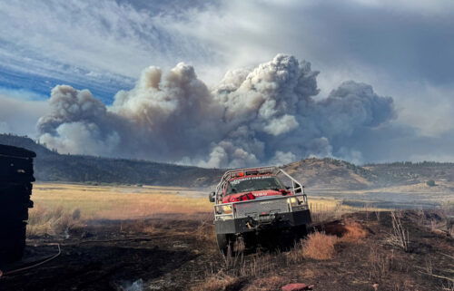
Canyon Creek crews keep fire from reaching Prairie City

Winds sent the more than 87,000-acre Canyon Creek Complex wildfire advancing north toward the town or Prairie City early Saturday, prompting evacuation of the southern half of the town, but crews protected the community and kept it from reaching it, officials said late Saturday.
As of Saturday, more than 850 firefighters had brought the 87,145-acre fire to 44 percent containment.
Here’s the Canyon Creek Complex Evening Update
Saturday, August 29, 2015 Fire Information: (541) 820-3643 or (541) 820-3633 Email Address: canyoncreekcomplex@gmail.com Facebook: www.facebook.com/canyoncreekfireoregon and/or www.facebook.com/malheurnationalforest Malheur NF www.fs.usda.gov/malheur/ Inciweb: http://inciweb.nwcg.gov/incident/4495/ Twitter: @CanyonCreekFire and/or @MalheurNF
JOHN DAY, OR – Early this morning the fire became very active due to high winds and low humidity. The fire burned down through Shaw Gulch on the fire’s northeast flank, prompting the evacuations south of the John Day River in Prairie City.
Firefighters responded quickly with engines and bulldozers making a solid stand and kept the fire about 1 miles from Prairie City. Firefighters made steady progress on the fire throughout the rest of the day, and by 4 p.m., most evacuation levels decreased.
Fire crews used a combination of dozer line, hand crews and burnout operations to keep the fire from crossing the 60 road. Weather conditions limited the availability of air support, but ground crews and heavy equipment stopped the north and east progression of the fire. Firefighters noted trees torching along the dozer line, but the line is currently holding.
The western flank of the fire continues to be stable. Late in the afternoon, a column stood up in the High Lakes area. Crews on the southeast flank of the fire called for air support but were unable to get it due to winds. Due to extremely windy conditions today, the fire crossed the line near the top of Lake Creek Basin to the east. Once the winds subside, firefighters will go in after it and attempt to get a line around it.
Night shift crews will continue the day’s activities by providing structure protection, securing firelines and monitoring fire activity along the northeast side of the fire. Crews will work to reinforce and complete line in areas along the 60 road.
Oregon National Guard troops supported suppression efforts, conducted mop up operations on the fires southeast flank and worked to repair of firelines on the southwest flank. Tomorrow winds are expected to come out of the southwest with ridge top gusts 15-20 mph, and a good chance of rain. This weather could allow fire crews to make significant progress.
Varying levels of smoke continued to linger over the complex and the surrounding communities throughout the day and it is also expected for tomorrow. Two portable smoke monitors are currently deployed; one monitor is placed in Prairie City and the other in Seneca. Real-time smoke readings are available at http://oregonsmoke.blogspot.com.
Forest Closure related to the fire is currently in effect: the Canyon Creek Complex Fire Closure and the Strawberry Mountain Wilderness. Copies of the closure order and map are available at www.fs.usda.gov/detail/malheur/home/?cid=stelprd3845529.
Please be advised of fire traffic and smoky conditions throughout the area. Forest officials ask that the public stay clear of all fire-related activities.
Additional Information CR 62 and the 16 Road are open to through traffic. Highway 395 is open to traffic, however, firefighters, equipment and the power company are working along the side of the road and drivers should expect short delays. Drivers are urged to use caution and encouraged to drive with headlights on through these areas. Do not stop and go into burned areas for safety reasons. The Malheur National Forest is bringing in a burned area emergency response team (BAER) to develop a restoration plan.
Public Safety Alert: If traveling through the area that has burned, please do not leave your vehicles and walk through ashes due to hot spots, stump holes and falling trees.
Ready, Set, Go – Given the current weather and fire conditions in Grant County, it is a good idea to be prepared for emergencies. Visit http://wildlandfirersg.org/ for further information about how to be prepared and what to pack for emergency evacuations. The American Red Cross also has important information regarding emergency preparedness. Go to http://www.redcross.org/support/emergency-preparedness for further tips and suggestions.
Additional area fire information can be found at JDIDC – BICC (John Day Interagency Dispatch Center – Burns Interagency Communication Center) sites online at http://bicc-jdidc.org/index.shtml.
Fire activity will likely have an effect on hunting this season. For more information, visit
www.dfw.state.or.us/resources/hunting/ For the latest Malheur National Forest news, please visit www.fs.usda.gov/malheur or follow the Forest on Facebook at U.S. Forest Service-Malheur National Forest or on Twitter at @MalheurNF.
Reporting To report a fire, contact the John Day Interagency Dispatch Center at (541) 575-1321 or the Burns Interagency Communication Center at (541) 573-1000.
Evening evacuation update:
Fire Information: (541) 820-3643 or (541) 820-3633
County road 62 from Prairie City south to the 16 road is open
Level 3 Evacuations: Canyon Creek Complex All of Strawberry Road Upper Pine Creek from Berry Ranch Lane and Dean Creek/Baldy Mt. Upper Indian Creek Road from the Y south (including both the 55 and the 71) Upper Dog Creek, south of Little Dog Creek The area west of County Road 62, south of the forest boundary (MP 12) and north of the 16 to the junction of FR 15/16 is in a level 3 evacuation. CR 62 and the 16 are open for through travel, at this time. Forest Closures remain in effect. Current Forest Orders are available at: http://www.fs.usda.gov/detail/malheur/home/?cid=stelprd3845529.
Level 2: Canyon Creek Complex Area South and West of the 62 Road from Prairie City to the Forest Boundary All of Prairie City back to Level 2 Lower Pine Lower Dog Lower Indian Creek Gardner Ranch Lane has dropped to a level 2 From J – L south to the end of County Road 65.
Evacuees: The Red Cross Relief Center is at the Mount Vernon Community Hall.
Road Closures: County Road 60 (Strawberry Road) is closed except for fire traffic and homeowners. Homeowners on the lower Little Canyon Mountain Trail area can also access their homes. The 15 road remains closed.


