Wheeler County fire grows to 310 acres; lightning map technology assists C.O. fight
REDMOND, Ore. (KTVZ) -- Wednesday night's lightning storm sparked dozens of fires across Central Oregon that have all been caught fast and small so far -- and one to the east, in Wheeler County, that has topped 300 acres.
Central Oregon firefighters had responded to 31 lightning-sparked fires by Thursday evening, ranging from a single tree to nearly a half-acre in size.
But quick action by fire crews and others meant all were caught during an initial attack. And the stronger winds Thursday did not push any of the fires outside of their lines, officials said.
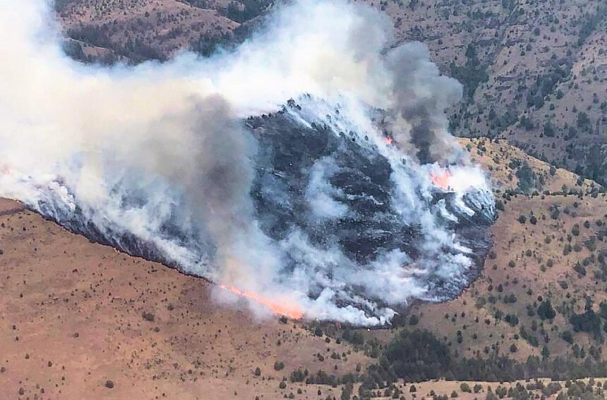
The Buckhorn Creek Fire broke out Wednesday in steep, rugged BLM land and had burned an estimated 310 acres by Thursday evening. The 80 firefighters assigned to the blaze were brought in by helicopter, due to the difficult access.
Single-engine air tankers were used Wednesday evening to slow the fire's spread, joined Thursday by a bulldozer, helicopters and more SEATs, helping crews get the fire 50% lined by the end of the day.
State and federal firefighting officials are concerned that more blazes are still smoldering, undetected.
Fighting wildfires can be a marathon, so the Oregon Department of Forestry is utilizing technology to get ahead and attempt to outsmart the flames.
Lightning can put on a dramatic light snow, but they also come with dangerous and lasting implications on communities, forests and rangeland.
Wednesday night brought 16 wildfires, with more found Thursday, keeping crews busy across the region in full force to limit the spread.
ODF has teamed up with multiple agencies to use real-time lightning detection maps in order to pinpoint where fires begin, and where they may arise.
They also commission special recon flights to be the "eye in the sky" for any possible outbreaks.
"We have lightning tracker technology, so we know roughly where the strikes hit," ODF's Jamie Knight said Thursday. "I take that information and overlay on a map, so I can actually fly over the areas with the heaviest concentrations, or areas of particular concern."
Single-engine passenger planes can be seen flying over Oregon's forests to scope out any signs of smoke or heat. The flights can last up to four hours, until a refuel is needed.
Knight and her incident management team say they do their best to maintain a bird's-eye view, in case crews are needed to be sent out immediately.
Multi-mission aircraft, equipped with electro-optical cameras and infrared scanners, are also sent out at night.
ODF also maintains a close relationship with the Central Oregon Interagency Dispatch Center in Redmond. Their mission is to provide support and coordination for all participating government agencies during emergencies like wildfires.
Christie Shaw, spokeswoman for ODF's Central Oregon District, says this summer so far is on par for wildfire season, but her team always anticipates the worst. Their primary concern is a "big wind" event, expected to be just on the horizon.
For now, ODF urges the community to work together and point out any signs of flames or smoke
