Remains, cockpit voice recorder recovered at Warm Springs jet crash site

(Update: NTSB says cockpit voice recorder found)
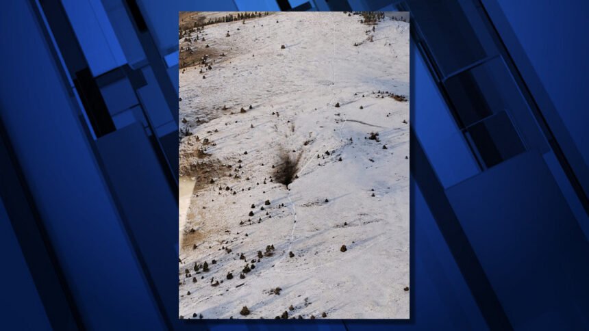
WARM SPRINGS, Ore. (KTVZ) – The remains of at least two people and the cockpit voice recorder have been recovered from the scene of a twin-engine business jet crash Saturday afternoon in the Mutton Mountains on the Warm Springs Indian Reservation, authorities said Monday.
The recorder will be shipped to the National Transportation Safety Administration recorders lab in Washington, D.C., said Christopher O'Neil, the NTSB's chief of media relations.
Wreckage recovery continues, O'Neil said, and it will be transported to a secure location for further information.
Federal Aviation Administration spokeswoman Marcia Adams said local authorities reported reaching the wreckage of the Cessna C560 jet shortly after noon Sunday near the community of Pine Grove, and that preliminary reports indicate the plane, capable of carrying 11 passengers, had two people aboard.
Warm Springs police Lt. Ron Gregory said Monday that Saturday's initial search effort stalled due to downed trees over major access points. The effort resumed Sunday morning, and crews spent about eight hours locating the site and searching the wreckage.
The release of names is pending, Gregory said, confirming identification and notifying their families.
The pilot had filed an instrument flight rules flight plan from Troutdale Airport, east of Portland, to Boise, O'Neil said Sunday.
O'Neil told NewsChannel 21 investigators are still awaiting complete weather reports, but Troutdale was under visual flight rules at the time of his departure, with 10 miles visibility and a 12,000-foot ceiling.
"There did not appear to be any significant weather along the accident route of flight," he added.
FAA air traffic controllers lost communication with the plane around 1:30 p.m. Saturday near Pine Grove, which is located just north of the reservation boundaries, FAA spokeswoman Arlene Salac said.
The FAA issued an alert notice shortly before 2 p.m. to public safety agencies, pilots and airports, alerting them of the missing aircraft, as search and rescue efforts got underway, Salac said.
Warm Springs Police Chief Bill Elliott said the Warm Springs Dispatch Center received a report around 2:30 p.m. from Seattle Air Traffic Control of the possible plane crash in the area of the Mutton Mountains, located in the northeast corner of the reservation.
The crash site was confirmed by a U.S. Air Force military flyover, as well as an Oregon State Police aircraft, Elliott said.
Warm Springs police responded, with the assistance of Warm Springs Fire and Safety, the Wasco County Sheriff’s Office and OSP. Wasco County SAR also was en route to assist, Elliott said Saturday evening.
The plane crash site was near the S-390 road, accessible from the S-300/Highway 3 from Schoolie Flat and Simnasho.
“Road conditions make access difficult, due to snow and mud,” Elliott said in an initial news release, adding that “officers are utilizing ATVs to reach the crash site.”
Gregory said, "We had a real difficult time getting there (Saturday) night. "We had a lot of downed trees. The (darkness) played a factor. Snow wasn't bad, but we had a lot of mud."
The NTSB spokesman said Sunday a preliminary report is usually released 10 to 15 days after a crash.
