C.O. wildfires: Frog Fire at 3,700 acres, plume visible; air quality advisory issued
(Update: More Frog Fire area closures by USFS)
Green Ridge Fire grew to nearly 2,000 acres by Thursday
BEND, Ore. (KTVZ) -- Firefighters working in hot, windy conditions saw major growth Wednesday on several wildfires across Central Oregon, and that growth continued Thursday, despite a bit of a cooldown, putting up tall smoke columns and prompting an air quality advisory for smoke.
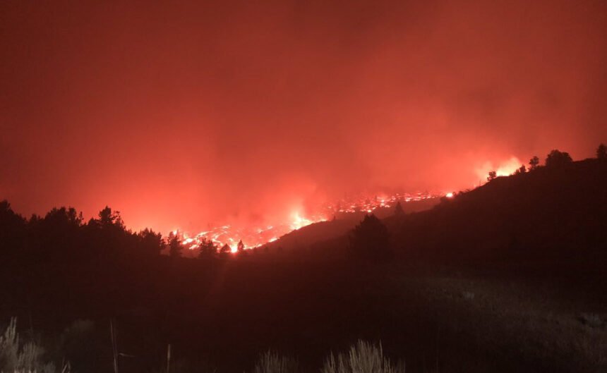
The Green Ridge fire, about 12 miles northwest of Sisters, Oregon pushed across containment lines Wednesday on the eastern edge of the fire. In one spot, the fire crossed the FS 11 Road, though firefighters quickly caught that edge with a bulldozer line.
The fire continued to back down the west side of Green Ridge, and rolling material on the northwest edge of the fire caused a small area of slop-over overnight. The fire has been mapped at 1,937 acres. A virtual public meeting is planned for Friday, and more details will be provided in a future update.
Firefighters will continue to use dozers to create containment lines on the eastern 2/3 of the Green Ridge fire line, while crews hold and improve the line through the heat of the day.
Where the fire continues to back down the steep slopes of Green Ridge, firefighters will dig hand line to stop the fire’s progress. The heavy and medium helicopters will continue to support the ground effort with bucket drops, and heavy air tankers will be available if the fire is pushed outside of containment lines again today. Information for the Green Ridge Fire can be found at: https://inciweb.nwcg.gov/incident/7012/. A video of this morning’s briefing on the Green Ridge Fire can be found at: https://www.facebook.com/NorthwestTeam10/videos/1199501773745681/
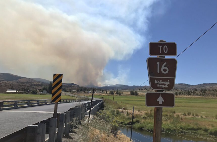
The Frog Fire in the Maury Mountains on the Ochoco National Forest, about seven miles southeast of Prineville Reservoir, had significant growth Wednesday and as of Thursday morning was at 3,700 acres, with no containment.
The towering smoke column from the Frog Fire was visible from Prineville Bend and many parts of the High Desert on Thursday. Fire officials placed an information board at the junction of Forest Road 16 and Highway 380 for information on that and other nearby fires.
Firefighters worked throughout the night on structure protection in the area. Crews will work Thursday to establish an anchor point in the northwest corner of fire to help with containment.
An area closure was established Thursday for the safety of the public and firefighters working in the area.
Ochoco National Forest Implements Temporary Area Closure for Frog Fire
Prineville, Ore. – Effective immediately, Ochoco National Forest officials have put in place an area closure for the Frog Fire burning in the Maury Mountains on the Ochoco National Forest. The Frog Fire, which started August 16 and is now estimated at 3,700 acres, is burning in the steep and rugged terrain of the Maury Mountains in heavy timber and now onto adjacent private rangelands and land managed by the Prineville District Bureau of Land Management.
The following area closure is in place
All lands managed by the US Forest Service west of NFSR (National Forest System Road) 17 in the Maury Mountains. Including Forest Service managed lands within T. 17 S, R. 18 E., sections 20-29 and 33-36; T. 17 S., R. 17 E., sections 19-36; T. 18 S., R. 18 E., sections 1-4, 9-12, 14, and 15; T. 18 S., R. 19 E., sections 1-12, 14-18, 22, and 23.
The following road closures are in place:
- All National Forest System Roads found within the area closure are closed.
- NFSR 17 will remain open for public use.
For more information on the Frog Fire, visit: https://inciweb.nwcg.gov/incident/7036/
Meanwhile Crook County officials said while ranch owners had been advised about the possible need for evacuation, there were no active fire evacuation notices on Thursday, though there were road closures:
Road Closures on the South End of the fire:
Roberts Road at Bear Creek
Klootchman Creek Road at Bear Creek
Salt Creek Road at Roberts Road
Road Closures on the North End of the fire:
Forest Service road 16 is closed at the Forest Service road 1610 intersection
A Type 2 Incident Management Team (D. Johnson) will take command of the fire at 6 p.m. Thursday.
The Lily Fire on Deschutes National Forest is 37 acres and 25 percent contained. The fire is holding on its eastern and western flanks. The fire burned out of the 1996 Charlton fire scar area in the north Wednesday.
The fire continues to burn in heavy timber. Firefighters are being assisted by a helicopter dipping out of Lily Lake.
An area closure has been put in place for this fire: https://www.fs.usda.gov/alerts/deschutes/alerts-notices. Hikers along the Pacific Crest Trail can detour around the closure near Charlton Lake and FS Road 4290 to the south and the Irish and Taylor lakes area to the north.
The Laurel Fire is burning on private land and Prineville District Bureau of Land Management land about seven miles northwest of Kimberly. Wheeler County Fire and Rescue, along with firefighters from the BLM and US Forest Service, are working on the approximately 1,000-acre fire along with single-engine air tankers (SEAT planes).
The Hog Ridge Fire 18 miles northwest of Dayville and north of Highway 26 near milepost 90 was estimated at 350 acres and 10% contained. Air tankers assisted crews and a dozer to construct line on Wednesday, and by the end of the day, fire behavior had moderated. Firefighters will continue holding and improving containment lines today.
For up-to-date information on Central Oregon fires, visit www.centraloregonfire.org or www.twitter.com/CentralORFire
Air quality advisory for Jefferson County, Warm Springs and Lakeview
Date: Aug. 20, 2020
PORTLAND, Ore. -- The Oregon Department of Environmental Quality issued an air quality advisory for the Jefferson County, Warm Springs and Lakeview areas due to smoke from nearby wildfires.
DEQ and partner agencies will continue to monitor smoke in these areas.
Smoke levels can change rapidly depending on weather. Check current conditions on DEQ’s Air Quality Index or by downloading the free OregonAIR app on your smartphone.
Smoke can irritate people’s eyes and lungs and worsen some medical conditions. Young children, adults over 65, pregnant women, and people with heart disease, asthma or other respiratory conditions are most at risk.
- Protect your health when smoke levels are high:
- Stay inside if possible. Keep windows and doors closed.
- Avoid strenuous outdoor activity.
- Be aware of smoke in your area and avoid places with the highest levels.
- Use high efficiency particulate air (HEPA) filters. These can be portable filters or can be installed in indoor heating, ventilation, cooling and air purification systems.
- If you have heart or lung disease or asthma, follow your healthcare provider’s advice.
Cloth, dust and surgical masks don’t protect from the harmful particles in smoke. N95 masks that are tested to ensure proper fit and that are worn correctly may provide protection. Otherwise, they might just provide a false sense of security. They are not recommended for strenuous activities and are in limited supply due to COVID-19. Additional information on wildfire smoke and COVID-19 can be found on the Center for Disease Control webpage.
DEQ’s color-coded Air Quality Index provides current air quality conditions and ranks air quality as follows: Green is good. Yellow is moderate. Orange is unhealthy for sensitive groups such as children, seniors, pregnant women and those with respiratory conditions. Red is unhealthy for everyone. Purple is very unhealthy for all groups. Maroon is hazardous.
Northwest Interagency Incident Management Team 10
Green Ridge Fire Update
August 20, 2020 – 9:45 am
Incident Commander Alan Lawson
Agency Jurisdiction: Oregon Department of Forestry/USFS-Deschutes National Forest
Email: 2020.GreenRidge@firenet.gov
Twitter: @CentralORfire
Green Ridge Fire Information: https://inciweb.nwcg.gov/incident/7012/
Central Oregon Fire Information: www.centraloregonfire.org
Fire Information Number: (360) 319-6582
| Date Started: August 16, 2020 | Acres: 1,937 |
| Cause: Lightning | Containment: 0% containment |
Jefferson County, Oregon – The Green Ridge fire started on August 16 approximately 12 miles northwest of Sisters, Oregon. High daytime temperatures and afternoon winds yesterday pushed the fire across containment lines on the eastern edge of the fire. In one spot, the fire crossed the FS 11 Road, and firefighters quickly caught that edge with a dozer line. The fire continued to back down the west side of Green Ridge and rolling material on the northwest edge of the fire caused a small area of slop-over overnight. The fire is currently mapped at 1,937 acres.
Today, firefighters will continue to use dozers to create containment lines on the eastern 2/3 of the fireline, while crews hold and improve the line through the heat of the day. Where the fire continues to back down the steep slopes of Green Ridge, firefighters will dig handline to stop the fire’s progress. The heavy and medium helicopters will continue to support the ground effort with bucket drops, and heavy airtankers will be available if the fire is pushed outside of containment lines again today.
A cooling trend today and tomorrow with lower temperatures and higher relative humidity should assist suppression operations; however, firefighters will still have to address typical Central Oregon afternoon winds. Fuel conditions remain extremely dry and contribute to fire spread. Crews will continue to grid outside the fireline to catch any spot fires that may occur.
The fire is staffed with almost 300 personnel including two interagency hotshot crews, two Type 2 initial attack crews, five 20-person handcrews, five Type 4 Engines, three Type 6 Engines, 11 dozers, two feller bunchers, eight water tenders, two skidgeons, three masticators and approximately 60 overhead positions.
Priorities continue to be public and firefighter safety, stopping fire movement to the 1120 road on the western side of the fire, and protecting private property, private timberlands and any critical infrastructure within and adjacent to the fire perimeter.
The Deschutes and Jefferson County Sheriffs’ offices issued a Level 2 (Get Set; prepare to leave at a moment’s notice) Evacuation notice for the following areas: residences north of Indian Ford Road; east of Green Ridge Rd 11 and west of Fly Lake Road (USFS 2055), and a Level 1 (Get Set) Pre-Evacuation notice for the following areas: residences along the south side of Indian Ford Road from Hwy 20 to Stevens Canyon Road; residences east of Fly Lake Rd (FS 2055) to Stevens Canyon Rd (including all residences along Stevens Canyon Rd); and private residences and campgrounds west of USFS 14 within the Metolius Basin in the Camp Sherman area. The departments will continue to work with fire managers to ensure public safety and prevent conflicts between citizens and fire operations.
The Deschutes National Forest also issued a fire closure order yesterday to minimize public entry into the fire area as well as reduce the amount of traffic on roads with increased fire vehicles. The closure extends from the east side of the FS 14 Road on the western edge, to the FS 1154 Road to the north, east of the FS 1129 Road on the eastern edge of the fire and the FS 1126 Road on the south. A complete description of the closure and a map can be found under the Announcement tab on the Green Ridge Fire page in Inciweb at: https://inciweb.nwcg.gov/incident/7012/
For the safety of the public and wildland fire personnel, all fire personnel are expected to follow recommendations from the Centers for Disease Control and Prevention (CDC) for preventing the spread of COVID-19. This includes limiting public access to the Incident Command Post (ICP) at Sisters Middle School and establishing alternate methods of public communication such as virtual public meetings and conference calls with cooperators. While COVID-19 circumstances are rapidly evolving, and federal agency guidance continues to adapt with the situation, NW Team 10 is prepared for wildland fire activity during this time.
News release from the Oregon Dept. of Forestry:
SALEM, Ore. - ODF has deployed Incident Management Team 2 led by Chris Cline to manage two fires burning in ODF’s Central Oregon District. The Laurel Fire is 5 miles south of Spray. It’s cause is unknown at this time. The lightning-caused Steet Mountain Fire is 9 miles north of Monument. Both were reported yesterday, Aug. 19.
The Steet Mountain Fire was estimated at 450 acres in timber on ODF-protected land and is reported at 77% contained. The Team will inbrief at 2 p.m. this afternoon. Other ODF fires in the District will likely be added to create a Complex under Team 1 overall management.
The Laurel Fire is burning on Bureau of Land Management land but management of the fire will be coordinated by ODF Team 1 under a cooperative agreement. This morning the Laurel Fire was reported at approximately 1,000 acres actively burning in grass with 0% containment.
ODF IMT 1 has demobilized from the Mosier Creek Fire, which is well along in mop up. That fire is again being managed by ODF’s The Dalles Unit in the Central Oregon District.
