More progress: Level 1 evacuation alerts lifted near Green Ridge, P-515 fires
Deschutes National Forest area near wildfire still closed
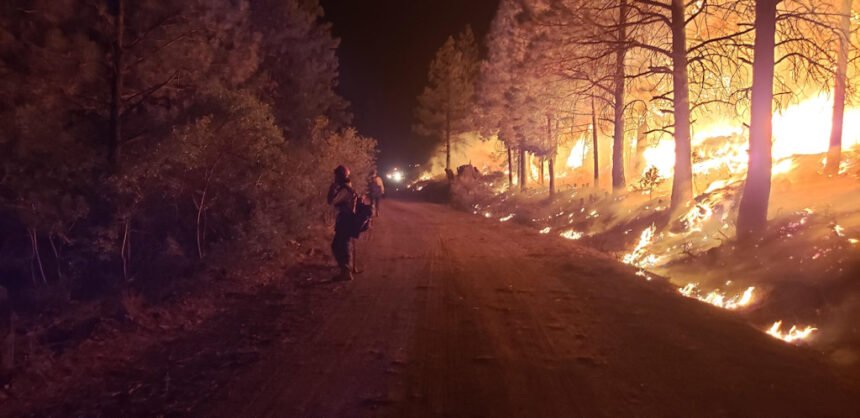
CAMP SHERMAN, Ore. (KTVZ) -- Firefighters continue to make good progress on containing the more than 4,300-acre Green Ridge Fire northeast of Camp Sherman, so officials Thursday lifted Level 1 pre-evacuation notices in the area.
A similar move occurred for an area near the P-515 Fire on the Warm Springs Indian Reservation, while crews on the Frog Fire in the Maury Mountains east of Prineville have brought it to 65% containment.
Here's a news release from the Deschutes and Jefferson County sheriff's offices, followed by Thursday's updates on the Green Ridge and other area wildfires:
Firefighters have continued to make good progress on the Green Ridge Fire. At this time, all Level 1 (Be Ready) Pre-Evacuation notices have been lifted.
There are still area closures in place issued by the Deschutes National Forest. Please use caution in the area around he Green Ridge Fire as fire personnel and equipment will continue to be working in the area.
For up to date information, follow:
- Deschutes County Sheriff’s Office on Twitter and Facebook
- Jefferson County Sheriff’s Office on Facebook
Current maps including evacuation areas can be found at: www.deschutes.org/emergency
For fire information, you can visit the Central Oregon Fire Information site at: www.centraloregonfire.org
Green Ridge Fire update:
Size as of IR flight: 4,348
Containment: 30 %
Start Date/Time: August 16, 2020
5:05 p.m.
Location: Camp Sherman, OR
Cause: Lightning
Personnel: 768
Assigned Resources:
Hand Crews: 27
Engines: 31
Dozers: 5
Water Tenders: 18
Other Heavy
Equipment: 7
Assigned Aircraft: 4
Structure Task Forces: 0
Injuries: 0
Structures
Threatened:
0
Structures
Damaged:
0
Structures
Destroyed:
0
Camp Sherman, Ore. – The Green Ridge Fire stands at 4,348 acres with no growth in the last 24 hours. The perimeter of the fire is now completely lined with 30 percent containment. Evacuation level notifications will be lifted at 11:00 a.m. today.
Success was found on the north side of the fire yesterday in a challenging area dubbed “the honeycomb” due to the number of small fires spotting over containment lines. Hard work and calmer conditions helped keep the fire in place for the first time in several days. That portion of the fire is now either lined with hose ready for mop-up or existing road systems. Fire crews will work the next several days to, as Operations Section Chief Eric Perkins puts it, “thicken the rind” of the perimeter through the mop-up process.
The east side of the fire, known as the head of the fire, has been another tough area due to the prevalent afternoon winds out of the west. With diminished wind activity Wednesday, fire crews were able to strengthen lines and begin mopping up into the perimeter, further lessening the chance of the fire spotting over the line.
The Deschutes National Forest Area Closure remains in place. FS Road 14 and associated campgrounds remain open. For information about evacuation notices and Forest Area Closures go to: https://inciweb.nwcg.gov/incident/7012/.
The Green Ridge Fire has had an individual test positive for COVID-19. The fire team’s response has been in accordance with the protocols developed by the Oregon Health Authority and in partnership with Deschutes County.
Protecting the health and safety of firefighting personnel and those in the local community is this team’s highest priority. ODF Team 3 remains committed to the safety of the public and wildland fire personnel. All fire personnel are expected to follow recommendations from the Centers for Disease Control for preventing the spread of COVID-19.
Warm Springs Fire update:
Quick Facts
Incident Summaries
P-515 / Lionshead
Approximate
Size in Acres: 4,609 ac. / 4,367 ac.
Fire
Containment 65% / 15%
Incident
Commander Eric Knerr
Resources on
the fire:
Crews: 22
Helicopters: 7
Engines: 21
Water Tenders: 9
Dozers: 8
Total
Personnel: 772
Jurisdiction:
Confederated Tribes
of Warm Springs
Oregon Smoke Blog
http://oregonsmoke.blogspot.com/
Inciweb
https://inciweb.nwcg.gov/incident/7050/
https://inciweb.nwcg.gov/incident/7049/
Warm Springs, Oregon - This update is for the P-515 Fire and Lionshead Fire burning on the Warm Springs Reservation. Both fires are being managed for full suppression.
Because of the progress made on the P-515 Fire, the Level 1 Evacuation (Get Ready) on Trout Lake Road west of US-26 has been lifted.
Current Situation: The P-515 Fire is 4,609 acres and 65% contained. Operations to secure the containment line along the perimeter continued through last night.
The Lionshead Fire is now 4,367 acres and 15% contained. Yesterday heavy equipment and hand crews worked to secure the north perimeter of the fire along the P-440 Rd. Increased fire activity on the southern flank led to several spot fires over primary containment lines. Firefighters were able to subdue one of the spots using aviation and ground resources.
P-515 Fire: Today, Crews will continue mop-up operations.
Lionshead Fire: Work on securing the J-200 road will continue, and crews will seek opportunities to secure the southern flank. Work will also continue to suppress and secure spot fires. Lookouts will closely monitor fire activity for any additional spotting south of the J-200 Rd. as the fire moves up the canyon. On the north flank crews continue preparing the P-440 Rd. using heavy equipment and hand crews.
Weather and Fire Behavior: Expect an inversion in the lowlands and valleys until late morning, and smoke local to and downwind of active fire activity. Ridgetop winds may become variable throughout the day, and gusts are forecast up to 18 mph. There is a potential again today for very active behavior on steep slopes.
Closures: Trout Lake Road at pavement end; Road B140 at Potter’s Pond; Road B210 and Road P-500. All trails south of Trout Lake, west of M-120 Metolious Bench, east of Mt. Jefferson, and north of J-195 will be closed to the public. Tenino Road (P-200) is closed to the public, with only fire personnel and residents are allowed.
Evacuations: The Level 1 Evacuation (Get Ready) on Trout Lake Road west of US-26 has been lifted.
COVID-19: Precautionary measures have been implemented to prevent the spread of COVID-19. These measures include daily temperature screenings, mandatory use of face coverings, social distancing, and implementing more virtual work. Public and firefighter safety are a top priority.
Prevention Message: While at home, do a yard project to improve your defensible space.
Frog Fire Update
Northwest Incident Management Team 8, Incident Commander, Doug Johnson
August 27, 2020 - 9:00 AM
The safety of the public and all wildland fire responders is always the number one priority for all wildland fire agencies. To keep firefighters and communities healthy and safe, all firefighters are asked to follow recommendations from the Centers for Disease Control and Prevention to reduce the spread of illness. This also includes limited entry into the incident command post and spike camp. Please see the websites below or contact the Frog Fire information center at 541-670-0812 for further fire information.
General Updates: Minimal fire behavior is expected with creeping and smoldering. Today, firefighters will continue mopping up across the fire and work on repairing areas impacted by fire suppression including dozer lines. Part of the repair work will be continuing cold trailing, which is where crews walk a grid pattern over an area looking for hot spots.
Favorable weather conditions continued yesterday, allowing firefighters achieve 50 to 200 feet of cold ground inwards from the perimeter in many areas. An extended network of hose lays on the northwest side of the fire is assisting their mop up progress.
Thunderstorms moved through the region south and east of the fire.
Acreage: 4,020
Containment: 65%
Fire Information: 541-670-0812 (8:00 am to 9:00 PM)
E-mail: FrogWildFire2020@gmail.com
Information Websites:
Twitter:@CentralORFire
Blog Site: http://www.centraloregonfire.org
Inciweb: http://inciweb.nwcg.gov/incident/7036/
Smoke: oregonsmoke.blogspot.com
Weather: Today’s weather will be sunny and drier. Temperatures will reach a high of 80 degrees, minimum Rh 14-18%, and winds 3-5mph from the south/southwest.
Air Quality: The air quality can change daily; up-to-date information for Oregon is available at oregonsmoke.blogspot.com.
Resources-480: 3-type 2 initial attack crews, 10-type 2 crews, 1-light helicopter, 16-engines, 3-skidgines, 2-dozers, 14-water tenders, and miscellaneous overhead
Evacuations: None
Closures: Several road closures and an area closure have been implemented near the Frog Fire.
The Crook County Sheriff’s Office has closed the following roads:
On the south end:
· Roberts Road at Bear Creek
· Klootchman Creek Road at Bear Creek
· Salt Creek at Roberts Road
On the north end:
· Forest Service Road 16 at the junction of Forest Service Road 1610
A temporary area closure has been implemented by the Ochoco National Forest. For a full description and map of the area closure, please see the above Inciweb link.
Temporary Flight Restrictions: For the safety of firefighters and aircraft fighting the Frog Fire, a temporary flight restriction has been placed over the fire area. Please consult the Notice to Airmen for specifics.
