Tuesday updates on wildfires, highway closures, evacuation notices
(Update: I-5 closure expands, Oregon Emergency Management info, three fires declared conflagrations)
DETROIT, Ore. (KTVZ) -- Several wind-fanned new and existing wildfires grew rapidly Monday night and Tuesday, prompting widespread evacuations and highway closures. Here's a roundup of the latest information.
ODOT Updates: 11:45 a.m.
U.S. 20 Santiam Highway is closed between Sweet Home and Santiam Junction, milepost 33 to 72, due to fire conditions. Avoid the area and watch for crews. OR 126 McKenzie Highway and OR 22 Santiam Highway remain closed by fire. OR 58 Willamette Highway is open for travel between the Willamette Valley and Central Oregon. Travel with extreme caution and be ready for conditions to change quickly. UPDATE
ODOT: Valley, No. Coast: OR 126 McKenzie Highway is closed by fire between Springfield and Belknap Springs, mileposts 10 to 55. In Springfield, only local traffic is allowed past 69th Street. Avoid the area and leave the road open for responders and evacuation. Check TripCheck.com or call 5-1-1 for alternate route information. Many roads are closed by fire, downed power lines and trees. UPDATE
ODOT: SW Oregon (5:22 p.m. update)
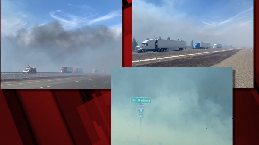
Updated/clarified I-5 closures in southern Oregon:
Closed - Interstate 5 Exit 1 northbound near the border to exit 24 Phoenix.
Southbound closure Exit 35 north of Central Point to Exit 14 south Ashland.
Oregon 99 closed between Phoenix and Talent.
Still no estimated time of opening. UPDATE
(1:30 p.m. update):
Drivers urged to exit interstate and seek local services in the Medford/Central Point area until fire conditions improve and the interstate reopens. We have no estimated time for reopening.
Expect delays. Avoid the area.
RE: I-5 closure near Ashland:
ODOT/OSP needs the drivers/operators of abandoned semi trucks/vehicles left on I-5 travel lanes to call dispatch to let them know your contact information for reopening the interstate.
Operators should call the numbers below to give contact information for dispatch to call back when the re-opening is close. Otherwise tows will be called, which will aggravate the closure.
ODOT Dispatch: 541-858-3103
OSP Dispatch: 541-664-4600 UPDATE
Deschutes National Forest release:
Oregon Department of Transportation Closes Highway 242 Due to Holiday Farm Fire
Sisters – Officials with the Oregon Department of Transportation in conjunction with the Deschutes and Willamette National Forests have closed Highway 242, which runs between Sisters and Highway 126, due to the nearby Holiday Farm Fire. Visitors currently in the area will need to proceed east on Highway 242 to Sisters.
Due to the evolving wildfire situation across the Central Cascades, visitors should check www.tripcheck.com for the safest, open route to their destinations. For local wildfire information please visit centraloregonfire.org or @CentralORFire on Twitter. For information on specific wildfire incidents visit https://inciweb.nwcg.gov/ and monitor local news sources.
Marion County Declares Emergency Due to wildfires
Marion Co. Sheriff's Office - 09/08/20 12:26 PM
Salem, OR – On Tuesday, September 8, 2020, the Marion County Board of Commissioners declared a State of Emergency for Marion County due to rapidly spreading wildfires in the county. Fires are expected to continue and have required evacuations.
The emergency declaration allows the county to seek resources from the state government and implements the county’s Emergency Operations Plan. It provides for emergency purchasing procedures and more flexibility for personnel utilization.
The county will take all necessary steps to coordinate response and recovery from this emergency.
Commissioner Colm Willis, chair, said, “Our sheriff’s deputies and police and fire agencies were heroic and aided hundreds of people last night in the midst of fire. We will continue to work around the clock to protect our communities. My thoughts and prayers are with everyone who has lost homes or loved ones in this horrible fire.”
Current evacuations include:
Level 3: “Go”
Lyons
Mehama
Detroit
Idanha
Hwy. 214 north of Silver Falls State Park to Scotts Mills
Level 2 evacuations: “Be Set”
Stayton
Sublimity
Aumsville
Silverton
Hwy. 213 west Mt. Angel Silverton to Drakes Crossing
An evacuation staging area has been established at the Oregon State Fairgrounds. Additional information is available at (503) 391-7294.
Late Tuesday AM Marion County Sheriff's Office evacuation update:
******UPDATE*******
Current Level 3 evacuations: This is a Go order
Lyons,
Mehama,
Detroit,
Idanah,
214 North of Silverfalls State Park to Scotts Mills
Current Level 2 evacuations: This is a get ready to Go order
Stayton,
Sublimity,
Aumsville,
213 West Mt Angel Silverton to Drakes Crossing.
Hwy 22 continues to be closed from the city of Stayton through the Santiam Canyon. If you have to evacuate, you will be allowed to get out of the canyon, but no one will be able to return.
Red Cross is set up at the Salem State Fairgrounds located at 2330 17th ST NE Salem, OR 97301
They are accepting animals and livestock.
• (If you have livestock , please enter on the south side of the fairgrounds)
Deschutes County Fairgrounds 3800 SE, SE Airport Way Redmond, Or 97756
McKenzie Fire evacuation information:
(More information at Lane County Sheriff's Office Facebook page)
Level 3 GO NOW Evacuation notice has been issued for everyone from Walterville Elementary east to the McKenzie Ranger Station, including all roads to the north and south of the highway.
The updated evacuation point is Thurston High School for those in Blue River and west of Blue River. Those east of Blue River should travel east to the Deschutes County Fairgrounds in Redmond (3800 SE Airport Way).
Level 3 means leave immediately! Do NOT take time to gather things. GO NOW! DO NOT delay leaving your property to gather any belongings or make efforts to protect your home. If you choose to ignore this notice, public safety personnel may not be available to assist you further.
LEVEL 2 BE SET EVACUATION NOTICE for residents from the McKenzie Ranger Station to the junction of Highway 126 and Highway 20 (Santiam Junction).
LEVEL 2 BE SET EVACUATION NOTICE has been issued for all residents from Walterville Elementary west to Thurston Road, including Deerhorn Road and all adjoining roads.
Level 2 (Be Ready) indicates there is significant danger to your area and residents should either voluntarily relocate to a shelter or with family/friends outside of the affected area. Be ready to evacuate at a moment's notice.
Willamette National Forest news release, Tuesday AM:
Multiple fires exhibiting rapid growth across the Forest
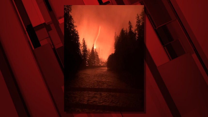
SPRINGFIELD, Ore. Sept. 8 -- Extreme fire activity, fueled by a rare fire weather event with low humidity and strong east winds, occurred on several fires located on the Willamette National Forest last night, closing state Highway 22 and prompting evacuations.
"As it becomes safe to do so, firefighters will begin to assess the fires and their impacts in alignment with sound risk management practices. Public and firefighter safety are the highest priority.
Multiple new fires started on forest, BLM and private lands along and in the vicinity of Highway 22 Thursday evening prompting a lengthy closure of the highway and Level 3 - Go evacuations extending from Lyons to Idanha. The cause of the fires is under investigation.
Fire spread was observed along all sides of the Beachie Creek Fire perimeter last night, with the greatest advance to the southwest. Firefighters will assess the fire’s movement today and engage it where they safely can. The Incident Command Post for Northwest Incident Management Team 13 is being re-established in Stayton.
Strong east winds pushed Lionshead Fire onto forest lands, prompting additional Level 3 - Go evacuations for the Breitenbush area and other locations in and around the Mount Jefferson Wilderness.
At approximately 8:30 p.m. last night, a new fire was reported on Forest lands at milepost 47 on Oregon Route 126, also known as McKenzie River Highway. The fire caused a closure of Oregon Route 126 and Level 3 - Go evacuations in the McKenzie River Corridor extending from Leaburg to the McKenzie River Ranger Station. Multiple resources including engines and rural fire departments continue response today under a full suppression strategy. The cause of this fire is also under investigation. Additional fires have been reported in the area.
Moderate to heavy smoke impacts from the fires are expected to continue along the western slopes of the Cascades and into the Willamette Valley. Stay informed on air quality ratings and more by visiting the Oregon Smoke Blog at http://oregonsmoke.blogspot.com/. Learn how to stay safe from wildfire smoke at https://www.cdc.gov/air/wildfire-smoke/default.htm.
A Red Flag Warning for the persistence of critical fire weather on the heels of this historic September event with low humidity and east winds of 15 to 30 mph and gusts up to 50 mph remains in effect until 8pm Wednesday. Conditions during this time will remain favorable for continued rapid fire spread.
All recreation offerings across the Willamette National Forest are currently closed, including campgrounds, day use areas, trails, boat ramps and more. Forest Service roads are closed to the public across the Willamette National Forest unless you are vacating the forest.
Forest visitors and nearby residents are encouraged to check with local emergency officials for the latest information on evacuations.
- Marion County https://www.facebook.com/MCSOInTheKnow
- Lane County https://www.facebook.com/LaneCountyGovernment
For the latest road and weather condition updates visit https://www.tripcheck.com/.
Additional fire information is available on Inciweb:
- Beachie Creek Fire https://inciweb.nwcg.gov/incident/7001/
- Lionshead Fire https://inciweb.nwcg.gov/incident/7049/
Please call 911 to report any signs of new fires.
Please observe public use restrictions and help us limit potential new starts during this time. A list of personal use restrictions, as well as closure orders area available at https://www.fs.usda.gov/main/willamette/fire. You can also follow us on Facebook and Twitter @WillametteNF.
Red Cross Cascades Region Facebook posting:
Oregon Wildfire Resources -
UPDATE 9/8 @ 11am - We are grateful that people want to help due to the Oregon wildfires. For the safety of everyone, we are unable to accept material donations of any kind right now. Financial donations at redcross.org are the quickest and best way to get help to those who need it most. Your financial donation to the Red Cross helps provide shelter, meals, relief supplies, emotional support, recovery planning and
other assistance during wildfires.
UPDATE 9/8 @ 8:45am - Our Red Cross volunteers are supporting those impacted by wildfires across Oregon this morning. We know there are many who are arriving at temporary evacuation points and need assistance. We will be available for as long as the need remains.
UPDATE 9/8 @ 7:45am - Red Cross volunteers are available at the following temporary evacuation points for those impacted by wildfires:
Thurston High School
333 58th St. Springfield
Deschutes Co. Fairgrounds
3800 SW Airport Way, Redmond
Oregon State Fairgrounds
2330 17th St NE, Salem
Glide Middle School
18990 N Umpqua Hwy, Glide
Kla-Mo-Ya Casino
34333 US-97, Chiloquin
Colton High School
30205 S Wall St, Colton
Simply show up to any temporary evacuation site for information on Red Cross services. Updates will be shared as they happen.
Statewide update: September 8, 2020
Oregon Office of Emergency Management - 09/08/20 12:42 PM
The Oregon Office of Emergency Management is assisting through the State Emergency Coordination Centermultiple counties encountering limited firefighting resources, challenging transportation access, as well as power outages and cellular service interruption.
Local evacuation information may be unclear due to power outages and a quickly changing situation. Stay tuned to trusted social media sources – county emergency management offices, Red Cross Cascades, state agencies such as the State Fire Marshal, Oregon Department Forestry, Oregon Department of Agriculture, etc. If Internet resources are not possible, contact your county sheriff’s department. If possible, check in on family, friends and neighbors to ensure their safety.
Know evaluation level actions and heed them!
- Level 1 – BE READY – Monitor emergency services websites and local media outlets for information. This is the time for preparation and precautionary movement of persons with special needs and, in some cases, pets and livestock.
- Level 2 – BE SET – Be ready to leave at a moment’s notice. There is significant danger to your area. Be prepared to voluntarily relocate to a Temporary Evacuation Point (TEPO as set up by the Red Cross, or move to family/friends outside of the affected area.
- Level 3 – GO – Leave immediately! Danger to your area is current or imminent. Do not delay leaving to gather any belongings or make efforts to protect your home.
Several roads are closed in affected fire areas and due to wind storm damage. Check TripCheck for the latest information. Additional statewide wildfire information can be found on the State of Oregon Wildfire Dashboard.
“Life safety is our number one priority,” said OEM Director Andrew Phelps. “Several jurisdictions have already declared a state of emergency. We are working closely with counties and tribes to assist in any and all ways that we can.”
Public Safety Power Shutoffs
PGE implemented a public safety power shutoff (PSPS) due to hot, dry, and windy conditions for about 5,000 customers located in high fire-risk areas near Mt. Hood. This is a proactive safety outage to help protect people, property and the environment in the face of extreme fire danger conditions and high winds forecast in the area. This is expected to last 24-48 hours.
For additional information about public safety power shutoffs, including a map of the affected area, go to PortlandGeneral.com/wildfire or call 503-228-6322 or 800-542-8818. Real-time information about unplanned outages can be found at PortlandGeneral.com/Outage.
Smoke
Smoke levels are currently fluctuating between unhealthy for sensitive groups and hazardous in areas closest to fires. Detroit, Florence, Eugene and Chiloquin – are having severe smoke impacts, as are other areas.
Smoke can irritate the eyes and lungs and worsen some medical conditions. Young children, adults over 65, pregnant women and people with heart disease, asthma or other respiratory conditions are most at risk.
- Stay inside if possible. Keep windows and doors closed.
- Be aware of smoke in your area and avoid places with the highest levels.
- If smoke levels are hazardous, consider leaving the area.
- Use high efficiency particulate air (HEPA) filters. These can be portable filters or can be installed in indoor heating, ventilation, cooling and air purification systems.
- If you have heart or lung disease or asthma, follow your healthcare provider’s advice.
Additional information on wildfire smoke can be found on the Oregon Smoke Blog.
State Park Closures
State parks that are closed until further notice include Silver Falls, Detroit Lake, North Santiam and Collier (north of Klamath Falls). No entry for any purpose is permitted.
COVID-19
Amid wildfire, smoke and erratic weather, the COVID-19 pandemic is still rampant. Face coverings are required in all parts of the state and Oregonians are reminded to maintain social distancing, and wash hands frequently.
Statewide update: September 8, 2020
Oregon Office of Emergency Management - 09/08/20 12:42 PM
The Oregon Office of Emergency Management is assisting through the State Emergency Coordination Center multiple counties encountering limited firefighting resources, challenging transportation access, as well as power outages and cellular service interruption.
Local evacuation information may be unclear due to power outages and a quickly changing situation. Stay tuned to trusted social media sources – county emergency management offices, Red Cross Cascades, state agencies such as the State Fire Marshal, Oregon Department Forestry, Oregon Department of Agriculture, etc. If Internet resources are not possible, contact your county sheriff’s department. If possible, check in on family, friends and neighbors to ensure their safety.
Know evaluation level actions and heed them!
- Level 1 – BE READY – Monitor emergency services websites and local media outlets for information. This is the time for preparation and precautionary movement of persons with special needs and, in some cases, pets and livestock.
- Level 2 – BE SET – Be ready to leave at a moment’s notice. There is significant danger to your area. Be prepared to voluntarily relocate to a Temporary Evacuation Point (TEPO as set up by the Red Cross, or move to family/friends outside of the affected area.
- Level 3 – GO – Leave immediately! Danger to your area is current or imminent. Do not delay leaving to gather any belongings or make efforts to protect your home.
Several roads are closed in affected fire areas and due to wind storm damage. Check TripCheck for the latest information. Additional statewide wildfire information can be found on the State of Oregon Wildfire Dashboard.
“Life safety is our number one priority,” said OEM Director Andrew Phelps. “Several jurisdictions have already declared a state of emergency. We are working closely with counties and tribes to assist in any and all ways that we can.”
Public Safety Power Shutoffs
PGE implemented a public safety power shutoff (PSPS) due to hot, dry, and windy conditions for about 5,000 customers located in high fire-risk areas near Mt. Hood. This is a proactive safety outage to help protect people, property and the environment in the face of extreme fire danger conditions and high winds forecast in the area. This is expected to last 24-48 hours.
For additional information about public safety power shutoffs, including a map of the affected area, go to PortlandGeneral.com/wildfire or call 503-228-6322 or 800-542-8818. Real-time information about unplanned outages can be found at PortlandGeneral.com/Outage.
Smoke
Smoke levels are currently fluctuating between unhealthy for sensitive groups and hazardous in areas closest to fires. Detroit, Florence, Eugene and Chiloquin – are having severe smoke impacts, as are other areas.
Smoke can irritate the eyes and lungs and worsen some medical conditions. Young children, adults over 65, pregnant women and people with heart disease, asthma or other respiratory conditions are most at risk.
- Stay inside if possible. Keep windows and doors closed.
- Be aware of smoke in your area and avoid places with the highest levels.
- If smoke levels are hazardous, consider leaving the area.
- Use high efficiency particulate air (HEPA) filters. These can be portable filters or can be installed in indoor heating, ventilation, cooling and air purification systems.
- If you have heart or lung disease or asthma, follow your healthcare provider’s advice.
Additional information on wildfire smoke can be found on the Oregon Smoke Blog.
State Park Closures
State parks that are closed until further notice include Silver Falls, Detroit Lake, North Santiam and Collier (north of Klamath Falls). No entry for any purpose is permitted.
COVID-19
Amid wildfire, smoke and erratic weather, the COVID-19 pandemic is still rampant. Face coverings are required in all parts of the state and Oregonians are reminded to maintain social distancing, and wash hands frequently.
This update contains information from other state agency reports.
State Fire Marshal Mobilizes Oregon Fire Service Resources to the Holiday Farm Fire and the Beachie Creek and Lionshead Fires
Oregon State Fire Marshal - 09/08/20 1:18 PM
Gov. Kate Brown has declared the Beachie Creek and Lionshead Fires in Marion County and the Holiday Farm Fire in Lane County as Conflagrations.
The Beachie Creek and Lionshead Fires were active overnight in the Santiam canyon. The Holiday Farm Fire is active near McKenzie Bridge.
The invocation of the Conflagration Act by Gov. Brown cleared the way for the State Fire Marshal to mobilize firefighters and equipment to assist local resources battling the fires.
The Office of State Marshal’s Green Incident Management Team has been mobilized to the Beachie Creek Fire and Lionshead fires and the OSFM’s Red Incident Management Team has been mobilized to the Holiday Farm Fire.
As of 8 a.m. this morning, four task forces from Marion, Benton, Linn, and Clatsop counties are deployed with the Green Team to support the Santiam Canyon communities being impacted by the Beachie Creek and Lionshead fires.
Two task forces from Polk and Yamhill counties are deployed with the Red Team.
Currently, evacuations have been ordered near both fires by local law enforcement.
In addition to its deployment of two IMTs, the OSFM has sent resources to Klamath County to support local firefighting resources who are responding to a fire near Collier State Park.
The predicted wind event has impacted much of the state. Multiple requests for structural firefighting resources have been made through the Oregon Fire Mutual Aid System.
All Oregonians should monitor communications coming from their local emergency response systems and communications from local law enforcement agencies, who are responsible for ordering evacuations.
The OSFM is asking residents to keep their fellow Oregonians and firefighters in their thoughts.
Additional updates for the incident may be accessed at:
• Oregon State Fire Marshal Facebook: www.facebook.com/OregonStateFireMarshal/
• Oregon Department of Forestry Facebook: www.facebook.com/oregondepartmentofforestry/
• ODF statewide wildfire blog: https://odfwildfire.wpengine.com/
• Wildfire Evacuation Readiness: www.oregon.gov/osp/programs/sfm/Pages/Wildland-Urban-Interface.aspx#evacuation
