Sunday updates: Lionshead, Beachie Creek, Holiday Farm, Two Four Two fires
(Update: Sunday evening Two Four Two Fire update)
BEND, Ore. (KTVZ) -- Here are Sunday's full updates on several of the major wildfires burning in or near Central Oregon.
Lionshead Fire Update – Sunday, September 13, 2020 – 9:00 a.m.
| Start Date: 8/16/2020 | Approx. Size: est. 138,718 ac. | Resources on the Fire: | Cooperating Agencies: |
| Cause: Lightning | Containment: 5% | 51 Crews | Marion Co. Sheriff |
| Incident Commander: | Total Personnel: 1482 | 62 Engines | Linn Co. Sheriff |
| Noel Livingston Pacific Northwest Team 3 | Approx. Distance: 20 miles west of Warm Springs | 11 Dozers 46 Water Tenders 10 Helicopters | Jefferson Co. Sheriff Deschutes Co. Sheriff |
Last night’s virtual community meeting can be found at: www.facebook.com/lionsheadfire
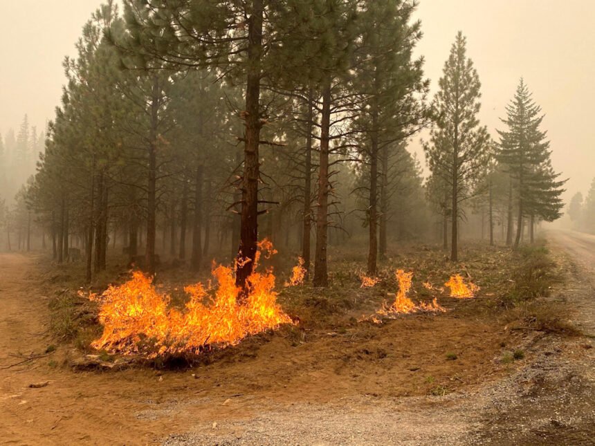
Weather and Fire Behavior: Heavy smoke will continue to cover the area, although winds aloft should begin to push smoke dispersement and begin to improve air quality throughout the week. Temperatures today will be cooler at 70-75 and humidity levels will range from 18-28 percent. Winds will be light and variable, on the fire aligning with terrain causing upslope, updrainage fire activity with group torching and spotting, becoming more active than we have seen the last couple of days. Interactive map of wildfires and forecasted smoke dispersement https://storymaps.esri.com/stories/usa-wildfires/
Current Situation: On the west side of the crest of the Cascades, engine task forces continue to secure and protect infrastructure and property, engaging in ongoing damage assessments as fire activity, smoke and other hazards allow. Progress is being made with scouting and preparing containment lines. Torching and spotting kept crews busy on Saturday on the northern side of the fire. Late in the afternoon heavy group torching aligned with the terrain and winds causing the fire on the northeastern corner to pass through containment lines. The control lines in place to the east and south on the Warm Springs Reservation continue to hold and show low fire activity. Firefighters diligently patrol and mop-up areas that may compromise the established control lines.
Today’s Activities: Firefighters on the west side of the crest of the cascades continue today with many of the same assignments as they worked on yesterday. Scouting old fire scars, road systems, trails and other natural barriers to incorporate into the containment lines. The Oregon State Fire Marshal Task Forces will continue to diligently work within the areas with property and infrastructure, stabilizing the communities and continuing the property damage assessments.
Wildfires have not burned in these areas for many decades, leaving heavy layers of fuels on the ground that firefighters must work through to secure the area, a very laborious and time-consuming process. Between the Olallie Lake area and the P-515 Fire, fire personnel will be assessing the terrain and potential natural barriers, old fire scars and road systems that can be used for containment lines.
The eastern and southern portion of the fire will continue to be patrolled and the mop-up depth will increase as needed to insure the fire stays within the existing perimeter.
Evacuations: A Level 1 Evacuation Notice has been issued for Sidwalter Flats area on the Warms Springs Reservation. Please monitor the local area sheriff’s department websites and Facebook for updates. The Oregon Office of Emergency Management has created an interactive database to help provide the most up to date information on evacuation statewide. https://www.oregon.gov/oem/emops/Pages/RAPTOR.aspx
Closures: For public and firefighter safety, roads and trails on the southwest portion of the Warm Springs Reservation near the fires are closed to the public. Forest closures are in place for Deschutes, Mt. Hood and Willamette National Forests. Deschutes NF Alerts Willamette NF Alerts Mt. Hood NF Alerts
FOR ADDITIONAL FIRE INFORMATION: Fire Information: 971-277-5075
TripCheck: https://www.tripcheck.com/
Inciweb: https://inciweb.nwcg.gov/incident/7049/
Facebook: www.facebook.com/LionsheadFire
Email: 2020.lionshead@firenet.gov
Beachie Creek Fire update:
Brian Gales, Incident Commander, NWIMT13 Les Hallman, Incident Commander, OSFM
| Start date: Aug, 16, 2020 | Location: Santiam Canyon west of Detroit, OR, Southern Clackamas County | Cause: Unknown |
| Fire size: 188,935 acres | Air Assets Assigned: 7 | Total personnel: 563 |
Beachie Creek Fire Update for Sunday, September 13, 2020
Salem, Ore. – Once the dense fog begins to dissipate, firefighters will resume work Sunday around the perimeter of the Beachie Creek Fire. Firefighters will begin mopping up and systematically accessing damage to structures inside the fire. Crews and heavy equipment will work Sunday to tie the pieces of existing control line together on the west and northwest portions of the fire. Line construction and reinforcement efforts which began Saturday south of Highway 22 will continue Sunday. Firefighters are working with landowners on the southeastern perimeter of the fire to build and secure control lines along that section of the fire.
The Beachie Creek Fire and the Riverside Fire remain about one mile apart. Despite the rumors, a merger of the two fires is not imminent. The current combination of winds, record dry forests, and a lack of natural holding features in the Table Rock Wilderness and surrounding areas mean it is still possible the fires could burn together in the coming days. Based on current weather, it is anticipated that a future merger would not result in dynamic fire behavior as seen in the last week.
Fire officials continue to work closely with the Marion County Sheriff’s Office, ODOT and the Oregon State Police to coordinate recovery efforts along the Santiam Canyon. Currently 16,776 structures are at Level 3 evacuations and another 18,528 homes in level 2 evacuations. It is imperative to protect first responders and communities in the path of the fire that everyone heeds fire and law enforcement road closures and evacuations. Anyone who enters the fire perimeter is jeopardizing firefighting and rescue operations, increasing the time it will take to return residents to their communities and putting lives at risk.
WEATHER: High pressure aloft will continue to slowly weaken Sunday and Monday. That means there could be some improvement in overall air quality Sunday afternoon, but valley inversions are likely to be persistent through the day. High temperatures Sunday will generally be in the upper 60s to low 70s, with forecast minimum relative humidity of 40-50 percent. The weather pattern is predicted to change early next week, with a good change of some rain Monday night and Tuesday.
SAFETY: Members of the public are encouraged to heed local evacuation orders issued by the county sheriff’s office and emergency notification systems. Know each Ready, Set, Go levels and make appropriate preparations. READY your belongings; SET your things at the door or prepack them in your car; GO and leave immediately.
SMOKE: Smoke will continue to be heavy across the area of the Beachie Creek Fire again on Sunday. This will lead to “unhealthy” and possibly “hazardous” conditions. Individuals with respiratory issues may find themselves affected by the intense smoke. Areas closest to fires - near Detroit, Florence, Chiloquin and Eugene - are having the worst smoke impacts. Smoke levels can change rapidly depending on weather. Check current conditions on DEQ's Air Quality Index or by downloading the free OregonAIR app on your smartphone.
CLOSURES: Willamette National Forest roads, trails, and lands around the fire area are closed. View the official order (Order 06-18-04-20-13) or go to InciWeb (link below) for a list and map of the closed roads, trails, and recreation sites.
| Public information: Facebook: facebook.com/BeachieCreek E-mail: BeachieCreek@gmail.com Phone: 541-583-0526, 8 a.m. to 8 p.m. | Inciweb https://inciweb.nwcg.gov/incident/7001/ Oregon Smoke Blog http://oregonsmoke.blogspot.com/p/air-quality-now.html |
Holiday Farm Fire Information
September 13th, 2020
Oregon Department of Forestry IMT 3
Link Smith, Incident Commander
Oregon State Fire Marshal's Red Team
Ian Yocum, Incident Commander
Holiday Farm Fire Information: (541) 357-9729 (7am—10pm)
Lane County Non-Emergency Call Center: 541-682-3977 (7am-10pm)
Linn County Non-Emergency Call Center: 541-812-2260
https://inciweb.nwcg.gov/incident/7170/
Estimated Size: 161,826 acres (no IR
flight yesterday)
Containment: 5%
Start Date/Time: 9/7/2020 8:20 p.m.
Expected
Containment Date: 10/29/2020
Location: Lane County
Cause: Unknown
Personnel: 628
Assigned Resources:
Hand Crews: 16
Engines: 45
Dozers: 6
Water Tenders: 13
Other Heavy
Equipment: 2
Assigned Aircraft: 4
Structure Task Forces: 5
Injuries: 0
Structures
Threatened: 23,556
Structures
Damaged: Assessing
Structures
Destroyed: Unknown
Evacuations: Level 1 (Ready), Level
2 (Set) and Level 3
(GO!) are in effect.
pringfield, Ore. –The hard work of wildland and structural firefighters on the Holiday Farm Fire east of Springfield is starting to pay off. Yesterday, the Lane County Sheriff’s Office lowered the evacuation level in the Mohawk Valley to 2 (BE SET). After several days with zero containment, fire managers now estimate containment at five percent. Containment reflects the fire managers’ confidence that existing control lines would prevent additional fire spread.
An infrared flight that usually takes place overnight to show changes in fire growth did not occur last night. The most current information estimates the fire perimeter at 161,826 acres.
Many residents in the Mohawk Valley and north of the Linn County line are affected by the drop in evacuation levels. Please note two important exceptions:
· West of Marcola Road south of the intersection with Hill Rd. is being downgraded from a Level 2 (BE SET) to a Level 1 (BE READY).
· East of the Mohawk River from Wendling Rd. to the Linn county line remains at Level 3 (GO NOW), including Wending Road, Paschelke Road, Hileman Road, Bunker Hill Road and Mohawk River Road and their connecting roads.
The evacuation level along Highway 126 from Thurston Road to Camp Creek Road, including Camp Creek Road, Upper Camp Creek Road and Cedar Flat Road is also being downgraded from a Level 3 (GO NOW) to a Level 2 (BE SET). All of Deerhorn Road remains in a level 3 evacuation.
Please note that dropping Level 3 (GO NOW) to Level 2 (BE SET) reflects that fire danger has subsided in that area enough to allow residents access to the area so they can make additional preparations for their homes, livestock or other animals. They should expect that if fire behavior increases these areas may return to Level 3 (GO NOW) and residents must be able to leave again at a moment’s notice.
Structural assessment continues today as crews are joined by an 80-person national urban search and rescue team (USAR). The USAR team will be working to locate unaccounted for people within the fire perimeter and start assessing structures. This will be a large-scale operation.
Crews dedicated to protecting structures yesterday made good progress along the Highway 126 corridor. They continued to improve fire protection for homes throughout the fire and executed mop up operations in the southwest portion of the fire, specifically in Goodpasture Loop and Deerhorn Road.
With more resources in place, fire crews have been able to construct direct control lines (adjacent to the fire’s edge) and indirect control lines (farther back from the fire’s edge). Firefighters completed a successful burnout operation in the southwestern corner of the fire to establish a solid control line. Additionally, crews have been mopping up, scouting locations for new control lines and removing snags to make areas safer for fire personnel and vehicles.
Structural firefighters continue to focus on protecting structures and mopping up around homes. Currently, the fire threatens 23,456 structures.
Fire managers request that the public please avoid the area. Some roads are closed in the fire area and much of the Willamette National Forest (WNF). Road hazards include falling trees and rocks and debris. For more information on closures on the WNF visit: https://www.fs.usda.gov/alerts/willamette/alerts-notices/?aid=61574
Many communities in Lane and Linn counties remain under Level 1, 2 or 3 evacuation orders.
Level 2 (BE SET) means there is significant danger to your area and residents should either voluntarily relocate to a shelter or with family/friends outside of the affected area and be ready to evacuate at a moment's notice. Emergency responders may not have time to provide you with additional notice if danger increases.
Please continue to monitor cell phones, landlines, local media and official information sources for evacuation updates. Current evacuation levels can be found at:
Lane County: www.lanecounty.org/mckenziefire
Linn County: www.linnsheriff.org/fire_live_updates_sept_2020/
Fire personnel are warmed by the community’s support but are unable to accept donations or use volunteers. The fire must use individuals with the appropriate qualifications. Those looking to volunteer or donate can connect with local organizations at:
https://www.lanecounty.org/cms/one.aspx?pageId=17035134
Two Four Two Fire
September 13, 2020 9:00 p.m.
Email contact—twofourtwofire.information@gmail.com
Public Information Line: (541) 846-8174
InciWeb—https://inciweb.nwcg.gov/incident/7159/
Facebook—https://www.facebook.com/TwoFourTwoFire/
Size: 14,584 Acres
Containment: 12%
Start Date: Sept. 7, 2020
7:00 p.m.
Expected
Containment Date: Sept. 25, 2020
Location: Northwest of Chiloquin, Oregon
Cause: Unknown
Est. Cost: $2.8 million
Personnel: 505
Resources: 9 hand crews
37 Engines
17 Dozers
12 Water Tenders
Aircraft: 4 Helicopters
Evacuations: Level 3: (Go)
Hwy 62 from mile post
100 to mile post 94
Hwy 422 North from
U.S. 97 to Hwy 62
North of Collier State
Park Logging Museum
on Glendale Drive
Level 2: (Get Set) None
Level 1: (Get Ready)
Highway 62 from milepost 94 to Sun Mountain Road
Structures
Threatened: 1,278
Structures
Damaged: 70
Structures
Destroyed: 35
Closures: Road Closures are in
place at: Modoc Point
Road from Hwy 62 to
milepost 1; Hwy 62
from milepost 94 to
100; and Hwy 422
North from Hwy 97 to
Hwy 62
Fire Summary:
We will be holding our third Facebook live virtual community
meeting on Monday. The meeting will start at 7 pm. Tune into our Facebook page for the latest updates.
All evacuation levels remain the same. Current evacuation levels
are shown above.
The fires acreage increased from yesterday’s update. Last night a
plane using an infrared camera captured a more accurate picture of the
fire and acreage size.
With high winds not picking up today as predicted, crews had another productive day on the fire. Firefighters are working on cutting down
dead and burned out trees and working around homes to cool any hot
spots. Crews are cleaning up around homes so residents can return home
safely.
Although the winds around the fire were lighter today than expected, weather forecasters predict high winds tomorrow and Tuesday.
Safety remains our top priority. This includes trying to prevent
COVID-19 infections. Personnel are following the Center for Disease Control guidelines. This means limiting personal contact within fire camp and
the community. The fire camp is closed to the public and media.
Oregon Department of Forestry IMT 2
Bill Hunt, Incident Commander
