Crews make progress on wildfire in Tillamook State Forest as bigger blazes battled across Oregon
(Update: New info on the Tillamook State Forest fire)
FOREST GROVE, Ore. (KTVZ) -- As crews fight numerous large wildfires across Oregon, they made progress on several, including a new blaze in the Tillamook State Forest.
Here's the Wednesday evening update on that fire;
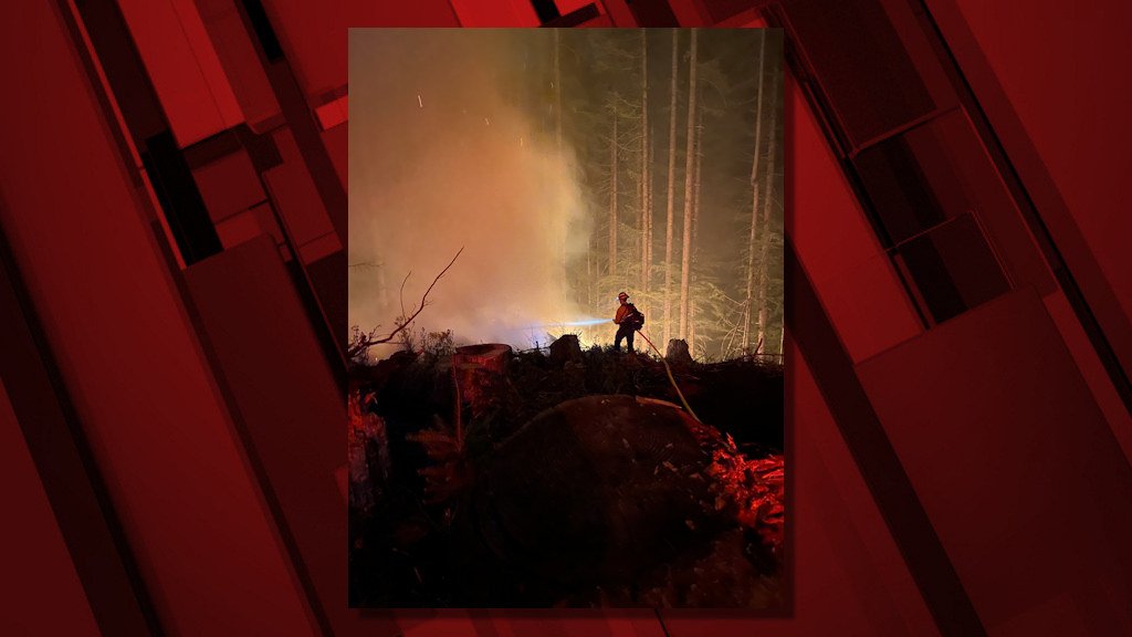
Firefighters made good progress today on the Game Hog Creek Fire burning 22 miles northwest of Forest Grove on the Tillamook State Forest. Although the fire remains uncontained because fire lines are still being built, the fire’s spread was largely stopped at about 70 acres. A helicopter kept the fire in check through the afternoon as temperatures rose. Steep portions where the fire is burning remain inaccessible to hand crews.
The night shift will continue to strengthen fire lines tonight. Smoke is expected in the area overnight but little fire growth. Tomorrow, firefighters will continue building containment lines and if all goes well start mopping up, cooling hot spots within the fire’s interior.
Firefighters from six Oregon Department of Forestry offices worked on the fire along with crews from South Fork. Hampton Lumber and Stimson Lumber Company provided water tender support.
Highways 6 and 26 to the coast remain open and unaffected by the fire, which is entirely within the state forest. Drift Creek and Idiot Creek forest roads are closed as is the Fear and Loaming mountain bike trail due to fire activity in the area. Rogers Camp trailhead is being used as a staging area for firefighters and is closed to the public. Elk Creek campground is open.
The fire was originally sparked on July 3 and contained then to six acres in a steep, inaccessible area. Rising winds Tuesday night apparently caused the fire to jump the control lines. Cause of the fire is still under investigation.
Here are updates on other blazes around the state, starting with the Bruler Fire south of Detroit Lake:
| Start date: July 12, 2021 | Location:Linn County, 7 miles south of Detroit on the Sweet Home Ranger District | Cause: Under investigation |
| Fire size: 90 acres | Air Assets Assigned: 1 | Total personnel: 47 |
Bruler Fire Update for Wednesday, July 14, 2021
Sweet Home, Ore. – Yesterday, firefighters took advantage of mild weather to make significant progress on the Bruler fire. A Type 2 helicopter continued dropping water to cool the interior while ground crews attacked the fire directly, digging handline for containment. Lines were further strengthened by two dozers, working to keep the fire within a small footprint. The fire is estimated to be 90 acres.
An additional 20 person hand crew and engines have arrived on the fire line. Northwest Incident Management Team 13, a Type 2 team, assumed command of the fire this morning. The fire is not currently threatening any communities or structures and there are no evacuation orders in place. The cause of the fire remains under investigation.
“We’re grateful for everyone who answered the call for the Bruler Fire,” said Sweet Home District Ranger and Agency Administrator Nikki Swanson. “I want to especially thank our partners and cooperators who have provided resources and support. You’re helping to keep our communities safe and to keep this fire as small as possible.”
WEATHER AND FIRE BEHAVIOR: Today, the weather will continue to be favorable including temperatures in the 70s and high relative humidity overnight. While the fire does still have potential to spread, fire behavior is expected to be moderate for the next few days allowing firefighters opportunities to make additional progress.
SMOKE: Air quality in the and around the communities of Detroit and Sweet Home continues to be listed as “good”. Light winds from the north and west are keeping smoke from the Bruler Fire and surrounding larger fires to the south and east.
CLOSURES: To provide for public and firefighter safety a large area closure is being finalized. This closure will encompass large portions of Forest Service lands south of Detroit Lake, west of Highway 22 and north of Highway 20. The closure will also include the Middle Santiam Wilderness, Daly Lake, Tule Lake and the trail network known as the Old Cascade Crest trail system. The closure will be posted to the Willamette National Forest webpage. Visitors are asked to avoid Bureau of Land Management (BLM) lands along the Quartzville Scenic Byway/Quartzville road including Yellowbottom Campground and Old Miner’s Meadow Group Site. Visit InciWeb (link below) for more information about closures in the area.
| Public information: Facebook: facebook.com/brulerfire2021 E-mail: 2021.bruler@firenet.gov Phone: 541-223-9601, 8 a.m. to 8 p.m. | InciWeb https://inciweb.nwcg.gov/incident/7663/ Oregon Smoke Blog http://oregonsmoke.blogspot.com/p/air-quality-now.html |
Bootleg Fire Wildfire
Location: 28 miles northeast of Klamath Falls, OR
Size: 212,377 acres
Containment: 5%
Personnel: 1,338
Dry and windy conditions contributed to another day of active fire behavior on the Bootleg Fire burning in Southern Oregon. Firefighters reported growth primarily to the east in the greater Gearhart Wilderness area. Air operations were severely limited due to unsafe flying conditions in heavy smoke.
“We’re making steady progress, where winds and terrain allow,” said Rob Allen, Incident Commander for PNW2 Incident Management Team. “But for the third day in a row, firefighters had to disengage at times for their safety, and weather isn’t going to change for the foreseeable future.”
On the ground, firefighters improved existing dozer and hand containment lines in the Fuego Mountain area. Crews took advantage of favorable conditions overnight to ‘burnout’ along these lines, significantly diminishing the potential for future fire growth toward the west in future weeks and leaving a solid containment line for the community of Chiloquin and Highway 97 in the area.
To the south and east, crews took advantage of yesterday’s inversion to make continued progress on improving dozer and other containment lines. Crews conducted ‘burnout’ operations overnight to strengthen those lines and increase containment. While the fire did not make expansive ‘runs’ as it did in past days, west winds continued to push fire growth toward the greater Snake and Round Butte areas under Red Flag conditions.
Community Meeting: Please join us for a virtual community meeting July 14, 2021 at 6:30 pm at www.facebook.com/BootlegFireInfo.
Evacuations: Evacuations are rapidly changing due to the nature of this wildfire. Please visit tinyurl.com/bootlegevac for an interactive map of evacuation level in Lake and Klamath Counties.
Closures: The Fremont-Winema National Forest is closed to the public in the fire area. Map and full order available at inciweb.nwcg.gov/incident/7609/.
Smoke: Heavy smoke expected July 14, 2021 with widespread impacts to communities and State Route 140 in Oregon between Chiloquin and Bly. Full report at: fires.airfire.org/outlooks/southcentraloregon.
Fire Information Public Phone: 541-482-1331
Facebook: www.facebook.com/BootlegFireInfo
Twitter: twitter.com/BootlegFireInfo
Hashtags: #BootlegFire #FireYear2021
July 14, 2021 Jack Fire Daily Update
Fire Update: Wednesday, July 14, 2021
Fire information: The Jack Fire is currently estimated at 13,907 acres and is 15% contained. Cooler temperatures and higher relative humidity the next few days will help resources hold the fire within the planned containment line. North of HWY 138, Crews will continue to hold, secure and mop-up along the 4760 Road moving east towards Dog Mountain. Firefighters will burn vegetation away from containment lines in the northeastern corner of the fire perimeter as needed to hold the fire within the planned containment area. In the Dry Creek area, crews continue mop-up around the structures.
South of HWY 138, on the western perimeter of the incident, the fire continues to move south along the 4714 road. Crews will continue to hold the fire east of the road, burning out vegetation as needed to strengthen the line. Crews are utilizing trails, roads, and hand lines to hold the fire within the planned containment lines on the southern-most edge of the fire. Today, firefighters will hold established containment lines while preparing lines to the south.
Structures: Structures have been prepped, structure protection enhanced and will be monitored by NW Team 9 and the Douglas Forest Protective Association.
Aviation: Four Type 1 aircraft and two Type 3 aircraft continue to support firefighters on the ground. Type 1 aircraft include Sikorsky and Kaman 1200 (KMax) helicopters along with a Type 3 A-Star helicopter. Air assets provide ground resources with water and retardant drops to limit the spread of the fire and to help establish and hold containment lines.
Evacuations: All Forest Service campgrounds (Apple Creek, Horseshoe Bend and Eagle Rock) are on Level 3 evacuation GO order. The Dry Creek community as well as all residences on the Illahee Road are also in Level 3 evacuation GO order. Level 2 SET evacuations were issued from mile marker 38 to 43. This includes Steamboat Inn and residences located on Brindle Bug Road, Steelhead Caddis Road, and residences and businesses located between mile post 51 and 55 on Highway 138E. Please visit the Douglas County Sheriff’s Office interactive evacuation map: www.dcso.com/evacuations
Closures: State highway 138E from Steamboat Creek to mile post 55 is closed to vehicle traffic. Steamboat Inn is also closed. Oregon Department of Transportation has set an eastside ‘soft closure’ checkpoint at Lemolo Lake junction to allow for local access into nearby recreation areas, including Lemolo Lake. Please visit https://tripcheck.com/ for updates on road closures. The Umpqua National Forest has issued UPDATED closure orders around the Jack Fire. The full closure order and map can be viewed on Forest website at www.fs.usda.gov/umpqua and on the Jack Fire Facebook page.
Weather: Cooler temperatures in the 80’s today. Winds will be light from the east northeast in morning, changing west northwest in afternoon, with gusts up to 15 miles per hour.
To see the latest on all of the wildfires in Oregon and the Northwest, visit https://inciweb.nwcg.gov/ (type 'Oregon' in the search box for the map to zoom in).
