Crews bring Darlene Fire near La Pine to 61% containment as residents return home
(Update: adding Saturday night update)
Level 3 evacuation orders dropped, community members can return home
LA PINE, Ore. (KTVZ) -- The nearly 700-acre Darlene Fire southeast of La Pine has been brought to 61% containment by the 220 firefighters working on the lines, officials said late Saturday as evacuated residents were able to return home, some to survey the damage left behind. It's expected to reach full containment Sunday.
Here's the full update from earlier in the day:
Darlene Fire Daily Update – July 17, 2021
Fire Information Phone Line: 425-324-1267 (7am - 7pm)
Email: darlenefireinfo@gmail.com
InciWeb (Incident Website): https://inciweb.nwcg.gov/incident/7665/
Facebook: https://www.facebook.com/deschutesnationalforest
Twitter: https://twitter.com/CentralORFire
Acres: 686
Number of Personnel: 202
Percent Containment: 35%
Cause: Under Investigation
Date/Time Detected: July 13, 2021, 1:30 p.m.
Origin/Location: La Pine, Oregon
La Pine, OR – Evacuations decreased in all areas surrounding the Darlene Fire yesterday afternoon and residents can now return to their homes and property. At 4:33pm on July 16th, the Deschutes County Sheriff’s Office and Klamath County Sheriff’s Office, in coordination with fire managers, adjusted evacuation levels as follows:
- All residences south of La Pine off of Darlene Way to the Deschutes/Klamath County Line including Old Ice Cave Rd have been reduced from a Level 3 (Go Now) Evacuation Notice to a Level 2 (Get Set) Evacuation notice.
- Areas south of the Deschutes/Klamath County line including most of township 23 east of Hwy 97, Sun Forest Estates, Split Rail, and Antelope Meadows, have been reduced from a Level 2 (Get Set) Evacuation Notice to a Level 1 (Be Ready) Pre-Evacuation notice.
Fire crews continued to work around the perimeter of the Darlene fire, extinguishing hot spots and strengthening containment lines; containment increased from 5% to 35% and the fire remained at 686 acres. Containment is expected to increase today, with low winds and favorable humidity levels forecasted.
The Northwest Incident Management Team 6 hosted a community meeting with agency administrators last night. Community members were able to receive answers to questions and many expressed gratitude for the firefighting efforts. Visit the Deschutes National Forest Facebook page for videos and summaries.
Evacuations: https://www.deschutes.org/sheriff/page/emergency-information
Closures and Fire Restrictions:
Bureau of Land Management/US Forest Service: All open fires are prohibited. All the units are at an Industrial Fire Precaution Level 3 (IFPL 3). Commercial and private firewood cutting is no longer permitted. These units will be moving to an IFPL 4 as of Saturday morning at 12:01 a.m. Information is available at https://www.fs.usda.gov/alerts/deschutes/alerts-notices.
Oregon Department of Forestry: Central Oregon is in regulated closure www.odfcentraloregon.com.
Walker Range: Walker Range is also in Regulated Closure www.walkerrange.org.
Earlier story:
Deschutes and Klamath County emergency managers reduced evacuation levels Friday afternoon on the nearly 700-acre Darlene Fire southeast of La Pine, meaning the folks who had to pack up and leave in a rush on Tuesday can now return home.
Areas which were at a Level 3 (GO NOW) changed to Level 2 (Get Set). That includes folks who live south of La Pine off of Darlene Way to the Deschutes/Klamath county line.
For people who live in the Sun Forest Estates, Split Rail or Antelope Meadows communities in Klamath County, the evacuation notices were reduced from a Level 2 to a Level 1 (Get Ready).
The Darlene Fire is now fully lined, officials said at a community meeting in La Pine on Friday evening. That means fire crews used roads and bulldozers to create a perimeter around the flames which cannot burn.
However, there's still much more work to be done.
“Just because it has a line around the fire does not necessarily mean it's contained,” explained Shawn Sheldon, the incident commander for Pacific Northwest Team 6.
Containment comes when crews have put out any hot spots, so the fire cannot get out of the lines they created.
Even though it's fully lined, the fire is still only 5% contained. Sheldon says he expects that number rise fast and to hit 100% by Sunday.
Even if that happens, though, he expects the flames will be around for a while.
“Some of these fires could burn for weeks,” Sheldon told NewsChannel 21. “If you're familiar with Western Oregon, we have fires that burned last year that still have heat in them after sitting over the winter."
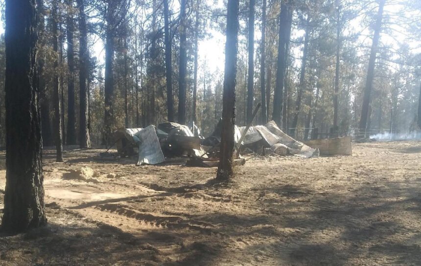
So there’s a long a long road ahead, but it’s trending in the right direction. Although some folks received good news Friday, others were not as fortunate. Deschutes and Jefferson County sheriff's deputies said the Darlene Fire destroyed two homes, along several outbuildings, RVs, and other vehicles.
EVACUATION LEVEL REDUCTIONS AROUND DARLENE FIRE (JOINT RELEASE)
Sgt. Nathan Garibay, Deschutes County Sheriff’s Office Emergency Manager
Brandon Fowler, Klamath County Sheriff’s Office Emergency Manager
The Deschutes County Sheriff’s Office and Klamath County Sheriff’s Office are adjusting evacuation levels around the Darlene Fire in coordination with fire managers.
The following areas have been reduced from a Level 3 (Go Now) Evacuation Notice to a A Level 2 (Get Set) Evacuation notice:
- All residences south of La Pine off of Darlene Way to the Deschutes/Klamath County Line including Old Ice Cave Rd.
Level 2: Means “BE SET” to evacuate. You must prepare to leave at a moment’s notice. This level indicates there is significant danger to your area, and residents should either voluntary relocate to a shelter or with family and friends outside of the affected area, or if choosing to remain, to be ready to evacuate at a moment’s notice. Residents MAY have time to gather necessary items, but doing so is at their own risk. This may be the only notice you receive. Emergency services cannot guarantee that they will be able to notify you if conditions rapidly deteriorate. Area media services will be asked to broadcast periodic updates.
The following areas have been reduced from a Level 2 (Be Set) Evacuation Notice to a Level 1 (Be Ready) Pre-Evacuation notice:
- Areas south of the Deschutes/Klamath County line including most of township 23 east of Hwy 97. This area includes Sun Forest Estates, Split Rail, and Antelope Meadows.
Level 1: Means “BE READY” for potential evacuation. Residents should be aware of the danger that exists in their area, monitor emergency services websites and local media outlets for information. This is the time for preparation and precautionary movements of persons with special needs, mobile property and (under certain circumstances) pets and livestock. If conditions worsen, emergency services personnel may contact you via an emergency notification system.
This decision was made after consultation with fire managers. We will continue to work with fire managers to ensure public safety and prevent conflicts between citizens and fire operations. Please refrain from unnecessary travel through these areas as fire equipment and personnel are moving through the area.
Several property owners sustained damage from the fire. At this time, preliminary reports indicate 2 residential buildings, several outbuildings, RVs, and other vehicles were damaged or destroyed. Property owners inside the fire area should be aware of hazards including burned trees, structures that may been destroyed by fire, and hazardous substances. Please use caution if your property was impacted by fire.
We appreciate the cooperation and understanding of residents.
Current maps including evacuation areas can be found at: https://deschutes.org/emergency
For fire information, you can visit the Central Oregon Fire Information site at: www.centraloregonfire.org
For American Red Cross assistance, please call 1-888-680-1455.
Darlene Fire Daily Update – July 16, 2021 (AM)
Fire Information Phone Line: 425-324-1267 (7am - 7pm)
Email: darlenefireinfo@gmail.com
InciWeb (Incident Website): https://inciweb.nwcg.gov/incident/7665/ Facebook: https://www.facebook.com/deschutesnationalforest
Twitter: https://twitter.com/CentralORFire
Acres: 686
Number of Personnel: 201
Percent Containment: 5%
Cause: Under Investigation
Date/Time Detected: July 13, 2021, 1:30 p.m.
Origin/Location: La Pine, Oregon
La Pine, OR - On the Darlene Fire yesterday, crews laid more hose around the perimeter of the fire and mopped up within the fire lines. They continue to secure the areas around structures as well. Fire operations today will include strengthening the containment lines and watching for any spot fires that could occur outside of the established lines.
Today’s temperatures are predicted to be in the low to mid 80s. Winds will be from the southwest switching to northwest in the afternoon again. Relative Humidity (RH) is coming back up with good recoveries at night, helping decrease fire behavior. Fuel moistures are still at record lows, especially for July, and firefighters will continue to watch for any spot fires that could ignite and spread rapidly.
Tonight, there will be a community meeting at the La Pine Park and Recreation District, 16405 1st St., at 6:00 p.m. The meeting will be streamed live on the Deschutes National Forest’s Facebook page https://www.facebook.com/deschutesnationalforest.
Evacuations: https://www.deschutes.org/sheriff/page/emergency-information
Level 3: Go Now Residences on Darlene Way south of La Pine to the Deschutes/Klamath County line, and along Old Ice Cave Road.
Level 2: Be Set Areas south of the Deschutes/Klamath County line including the Sun Forest Estates, Split Rail subdivision and Antelope Meadows.
Closures and Fire Restrictions:
Bureau of Land Management/US Forest Service: All open fires are prohibited. All the units are at an Industrial Fire Precaution Level 3 (IFPL 3). Commercial and private firewood cutting is no longer permitted. These units will be moving to an IFPL 4 as of Saturday morning at 12:01 a.m. Information is available at https://www.fs.usda.gov/alerts/deschutes/alerts-notices.
Oregon Department of Forestry: ODF Central Oregon is in Regulated Closure. Information is available at www.odfcentraloregon.com.
Walker Range: Walker Range is also in Regulated Closure www.walkerrange.org.
