Darlene Fire 85% contained, evacuation levels further reduced; Grandview Fire 57% contained
(Update: New containment figures)
BEND, Ore. (KTVZ) -- Here are Sunday's updates on the Grandview and Darlene fires in Central Oregon and other wildfires burning around the state.
Officials announced Sunday night that the Darlene Fire was 85% contained and the Grandview Fire 57% contained.
The Deschutes County Sheriff’s Office and Klamath County Sheriff’s Office announced Sunday evening they are adjusting evacuation levels around the Darlene Fire in coordination with fire managers.
The following areas have been reduced from a Level 2 (Get Set) Evacuation Notice to a Level 1 (Be Ready) Evacuation notice:
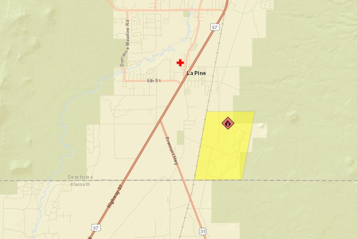
- All residences south of La Pine off of Darlene Way to the Deschutes/Klamath County Line including Old Ice Cave Rd.
All evacuation notices have been dropped in the areas previously in a Level 1 (Be Ready) Evacuation Notice:
- Areas south of the Deschutes/Klamath County line including most of township 23 east of Hwy 97. This area includes Sun Forest Estates, Split Rail, and Antelope Meadows.
This decision was made after consultation with fire managers. We will continue to work with fire managers to ensure public safety and prevent conflicts between citizens and fire operations. Please refrain from unnecessary travel through these areas as fire equipment and personnel are moving through the area.
Several property owners sustained damage from the fire. At this time, preliminary reports indicate 2 residential buildings, several outbuildings, RVs, and other vehicles were damaged or destroyed. Property owners inside the fire area, should be aware of hazards including burned trees, structures that may been destroyed by fire, and hazardous substances. Please use caution if your property was impacted by fire.
We appreciate the cooperation and understanding of residents.
Current maps including evacuation areas can be found at: https://deschutes.org/emergency
For fire information, you can visit the Central Oregon Fire Information site at: www.centraloregonfire.org
For American Red Cross assistance, please call 1-888-680-1455.
Grandview Fire Update, July 18, 9 a.m.
Sisters, OR – The Grandview fire acreage has been updated to 6,032 acres by using more accurate mapping information. Containment on the fire is now 43%.
The community meeting from last night can be viewed online in two places – Microsoft Teams – https://bit.ly/GrandviewFire2021 Facebook - https://fb.watch/6PVZefAq2c/ Temperatures over the fire will be in the lower 90’s and winds out of the NW at 5-8 mph.
Today, crews will continue mopping up deeper into the fire to 100 feet and more. Snags are a concern around the perimeter of the fire and felling crews will work to remove them to reduce risk of hazard to the other crews and the public.
For up-to-date information on the Grandview Fire, please visit: https://inciweb.nwcg.gov/incident/7651/ or Centraloregonfire.org
There are evacuation notices in place issued by the Jefferson County Sheriff’s Office https://arcg.is/D9OPi and Deschutes County Sheriff’s Office https://tinyurl.com/DeschutesCOEvacMap Please follow their guidance.
Jurisdictional agencies tied to the fire include Oregon Department of Forestry Central Oregon District and Ochoco National Forest, Crooked River National Grassland.
Darlene Fire Final Daily Update – July 18, 2021
Fire Information Phone Line: 425-324-1267 (7am - 7pm)
Email: darlenefireinfo@gmail.com
InciWeb (Incident Website): https://inciweb.nwcg.gov/incident/7665/
Facebook: https://www.facebook.com/deschutesnationalforest
Twitter: https://twitter.com/CentralORFire
Acres: 686
Number of Personnel: 220
Percent Containment: 61%
Cause: Under Investigation
Date/Time Detected: July 13, 2021, 1:30 p.m.
Origin/Location: La Pine, Oregon
La Pine, OR – Containment on the Darlene Fire increased to 61% yesterday evening as fire crews continued to secure lines around the perimeter. Today, fire activity is expected to remain low with some smoldering and minimal creeping behavior. Crews will continue to strengthen containment lines and work their way further into the interior of the fire perimeter, extinguishing any hot spots that they find.
Today’s weather is expected to be warmer and drier, with minimal impact on fire activity. Morning southerly winds will turn westerly in the afternoon but should remain light with a few gusts reaching 10-15mph. Relative humidity (RH) will decrease slightly, allowing moderate recoveries overnight.
Northwest Incident Management Team 6 will be transitioning with a local Type 4 Incident Management Team at 0600 Monday July 19/ All current fire communication including email, the phone line, and InciWeb will cease at 0600 Monday. For more information about the Darlene Fire after the team transition, call the Central Oregon Fire Information Desk phone at (541) 316-7711 from 7am to 7pm or visit www.centraloregonfire.org and follow on the Deschutes National Forest Facebook page.
Evacuations:
https://www.deschutes.org/sheriff/page/emergency-information
All residences south of La Pine off of Darlene Way to the Deschutes/Klamath County Line including Old Ice Cave Rd have been reduced from a Level 3 (Go Now) Evacuation Notice to a Level 2 (Get Set) Evacuation notice.
Areas south of the Deschutes/Klamath County line including most of township 23 east of Hwy 97, Sun Forest Estates, Split Rail, and Antelope Meadows, have been reduced from a Level 2 (Get Set) Evacuation Notice to a Level 1 (Be Ready) Pre-Evacuation notice.
Closures and Fire Restrictions:
Bureau of Land Management/US Forest Service: All open fires are prohibited. All the units are at an Industrial Fire Precaution Level 4 (IFPL 4). Commercial and private firewood cutting is no longer permitted. Information is available at https://www.fs.usda.gov/alerts/deschutes/alerts-notices.
Oregon Department of Forestry: Central Oregon is in regulated closure www.odfcentraloregon.com.
Walker Range: Walker Range is also in Regulated Closure www.walkerrange.org.
Bruler Fire Update for Sunday, July 18, 2021
Sweet Home, Ore. – The Bruler Fire south of Detroit has remained at 156 acres over the past few days since cooler temperatures, light winds and higher humidity helped firefighters by reducing fire activity. Firefighters were successful in placing hose around portions of the fire perimeter and have lined the entire fire with direct and indirect line. Containment is now listed at 10%.
Firefighters are working to bring indirect line closer to the fire perimeter to keep the fire size close to its current footprint. Keeping the fire small is a priority of the Agency Administrator and the Incident Commander.
Today, firefighters will continue to place sprinklers on the perimeter of the Bruler Fire. Sprinklers add water to the dry, dead and down trees and plants. The sprinklers will reduce the probability of fire spread, both within and outside the fire perimeter, by increasing the relative humidity in the fire area.
Heavy equipment will continue working on creating fuel breaks and saw crews will remove hazard trees along alternate and contingency lines. The preparation of these lines will help to contain the fire in the event it moves out of its current footprint.
A large closure area is necessary to ensure that firefighters can focus on managing the fire and not needing to evacuate visitors should conditions on the fire change rapidly. We appreciate the support of the public in allowing us to stay focused on firefighting and we will reduce the closure area as soon as possible. Safety issues associated with the Bruler Fire include many snags in the western side of the forest that can be dangerous to firefighters.
“Thank you to all of our firefighters for their diligence in keeping the fire footprint as small as possible,” said Agency Administrator Nikki Swanson.
WEATHER AND FIRE BEHAVIOR: Today, the weather will be similar to yesterday, with a marine layer that will burn off in the morning. Winds are forecast to be light, with gusts up to 15 mph on ridge tops. Similar temperatures, humidity and sky conditions are expected through early next week.
SMOKE: Air quality in and around the communities of Detroit and Sweet Home continues to be listed as “good.” Light winds from the west are keeping smoke from the Bruler Fire and surrounding larger fires to the east.
CLOSURES: A large closure area has been established to maintain firefighter and public safety. This closure encompasses large portions of Forest Service lands south of Detroit Lake, west of Highway 22 and north of Highway 20. The closure also includes the Middle Santiam Wilderness, Daly Lake, Tule Lake and the trail network known as the Old Cascade Crest trail system. The closure is posted to the Willamette National Forest webpage. A Bureau of Land Management (BLM) closure area is also in place for lands along the Quartzville Scenic Byway/Quartzville road including Yellowbottom Campground, Old Miner’s Meadow Group Site, and nearby dispersed camping areas. Visit InciWeb for more information about closures in the area.
| Public information: Facebook: facebook.com/brulerfire2021 E-mail: 2021.bruler@firenet.gov Phone: 541-223-9601, 8 a.m. to 8 p.m. | InciWeb https://inciweb.nwcg.gov/incident/7663/ Oregon Smoke Blog http://oregonsmoke.blogspot.com/p/air-quality-now.html |
Jack Fire July 18 2021 Daily Fire Update
Fire Update: Sunday, July 18, 2021
Fire information: The Jack Fire is currently estimated at 16,764 acres and is 35% contained. North of Hwy. 138, the focus for today’s efforts will be to reduce the chance of fire moving past containment lines by mopping up and securing lines. Along the northern flank, firefighters will continue burn operations to increase depth along fire lines. South of Hwy 138, firefighters continue burnout operations to build primary line on the west and southwest flanks. Along the southeast flank, crews will continue to utilize heavy machinery to clear and brush out roads used as control lines. Crews will also be scouting for alternative lines for possibility of creating a smaller footprint. Contingency line construction will continue with the primary focus to utilize existing roads as much as possible.
Structures: Crews continue to mop-up and patrol around structures in Dry Creek area and around Horseshoe Bend Campground.
Aviation: Air assets provide ground resources with water and retardant drops to limit the spread of the fire and to help establish and hold containment lines. Air support includes four heavy Type 1 helicopters and one light Type 3 helicopter.
Closures: Hwy. 138 remains open. Please be wary of fire traffic and follow posted speed limits to keep the many on-the-ground crews safe if you are traveling in the area. Visit https://tripcheck.com/ for more information. For your safety and the safety of others, the Umpqua National Forest closure orders remain in effect. The full closure order and map can be viewed on at www.fs.usda.gov/umpqua and on the Jack Fire Facebook page.
Evacuations: Effective Wednesday, July 14, 2021, at 5:30 pm, the following are evacuation levels issued:
- LEVEL 2 "BE SET" evacuation for all residences and businesses located between milepost 43 and 51 on Highway 138E, including the Dry Creek Community is in effect
- All residences and businesses located between milepost 38 and 43 on Highway 138E, including the Steamboat Inn and all residences located on Brindle Bug Road and Steelhead Caddis Road, are in a Level 1 "Be Ready" evacuation level
- All residences and businesses located between milepost 51 and 55 on Highway 138E are in a Level 1 "Be Ready" evacuation level.
- All residences and businesses located between milepost 55 and 60 on Highway 138E, to include the Slide Creek Village, Toketee Village and Clearwater Village, are no longer under a formal evacuation notice.
Current evacuation map can be found at www.dcso.com/evacuations The Sheriff's Office will continue to work with county commissioners, fire managers and agency partners to ensure public safety.
Weather: The weather will be similar to yesterday with a slight increase in temperatures. Temperatures will be in the mid to upper 80’s with light winds changing from east northeast in the morning to west northwest in afternoon. Gusts up to 15 mph.
Jack Fire Statistics: Acres: 16,764
Containment: 35%Personnel: 827Date of Ignition: 7/5/2021
Cause of Fire: Under Investigation
Structures Threatened: 243
Injuries: 6
Aircraft: 5 Dozers: 6 Engines 33
Other information: https://inciweb.nwcg.gov/incident/7605/
Elbow Creek Morning Update - July 18
Wallowa, OR – Oregon Department of Forestry’s Incident Management Team 3, led by Incident Commander Link Smith, in conjunction with key members from Oregon State Fire Marshal’s Blue Team, have assumed command of the Elbow Creek Fire 31 miles southeast of Walla Walla. The arrival of the fire management organization brings in additional overhead capacity and firefighting resources.
Progress was made yesterday on the northwest side of the fire with firefighting crews constructing line and stopping progression of the fire into the Elbow Creek Drainage. Dozer operations have assisted in cutting lines along the ridges on both the north and south ends of the fire. Burnout operations on the eastern portions of the fire were successfully performed last night.
Today, crews and equipment will pick up where the night shift left off and continue to connect containment lines in open areas. Additional task forces will be joining crews today.
Fire potential remains high, with warmer and drier conditions expected this afternoon. The topography of the area acts in funneling winds – accelerating rapid fire growth and erratic fire behavior.
The weather outlook for the week brings the potential of thunderstorms starting Monday afternoon through Tuesday morning. After receiving the team in-brief from local agencies, Incident Commander Link Smith noted, “This is going to be challenging, but we will give everything we have to protect the natural resources.” Oregon State Fire Marshal Chief Deputy Travis Medema echoed this commitment, adding OSFM’s presence aids in “protecting structures and further supporting the community.”
Closures: All Forest Service lands, roads, and trails within the Umatilla National Forest are closed. For more information visit the Umatilla National Forest website at www.fs.usda.gov/Internet/FSE_DOCUMENTS/fseprd931174.pdf
Additionally, the Grande Ronde River is closed.
A virtual community meeting will be held this evening on Facebook Live at 7 p.m. Evacuation orders remain in place with the most up to date map found on the Wallowa County Sheriff Facebook page.
Information: https://inciweb.nwcg.gov/incident/7672/
