Rain brings welcome relief on Bootleg Fire; Lake County lowers evacuation levels
BLY, Ore. (KTVZ) -- More than a half-inch of rain on some parts of the massive, 413,000-acre Bootleg Fire brought welcome relief for fire crews Tuesday, but the fire remains 53% contained and there's weeks more of containment and mop-up to do, officials said in Wednesday's update. Lake County, meanwhile, lowered evacuation levels on Wednesday.
Here's the full update:
Bootleg Fire Daily Update July 28
Location: 28 miles northeast of Klamath Falls, OR Size: 413,400 acres
Personnel: 1,924 Containment: 53%
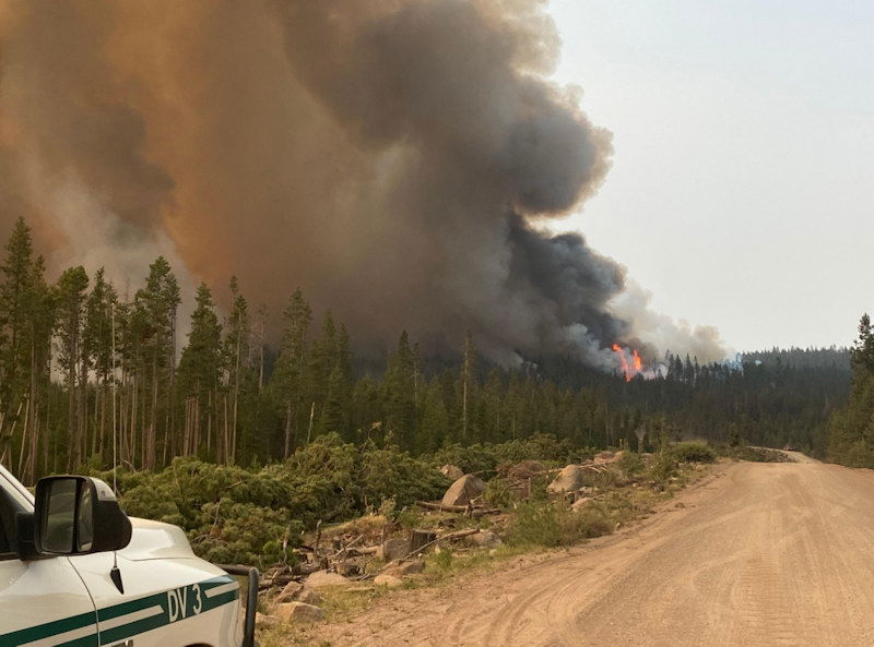
(Klamath Falls, OR) – The west side of the fire received steady, light rain that allowed more direct attack on the fire’s edge yesterday and overnight. The rain significantly moderated fire behavior. Fine fuels are most affected by the moisture, although larger diameter fuels are still critically dry. Some isolated torching occurred yesterday in heavy fuels, but spotting was much reduced.
On the east side of the fire, crews continued to mop up after the spot fire from yesterday. With the added moisture they have no concerns about that area today. The Oregon National Guard crews are working on the east flank of the fire area to secure the perimeter and put out any hot spots. Crews are completing lines on the fire perimeter near the Old Trunk road around the burned area of the 2018 Watson Creek Fire.
Along the Sycan River there is still active fire in the treed riparian area, but the wetter areas of the Sycan Marsh will likely remain unburned. The southern and western portions of the fire have shown little fire activity and remain in monitor and patrol status.
“The cooler temperatures and precipitation yesterday were a welcome change,” said Incident Meteorologist Chris Foltz. “A wetting rain fell yesterday dropping as much as 0.6 of an inch on the western area of the fire. The eastern side was a bit drier, but still received a tenth of an inch. Not all areas of the fire received rain, but overall the cooler, more humid conditions are beneficial for the firefighting crews.” The rain and cloud cover kept humidity levels above 60%. The rain tapered off overnight, although isolated thunderstorms are still possible, especially in the northwest region, over the next few days. Warmer temperatures will return and humidity will decrease starting today and over the next few days, so crews are watching for increased fire activity.
Evacuations: Evacuations are dynamic. Klamath County has dropped all evacuation notices; however, the Fremont-Winema National Forest remains closed. Lake County released an announcement of lowered evacuation levels. The most effective way to view the new designation boundaries is on the interactive map available at tinyurl.com/bootlegevac
Red Cross Evacuation Shelters: For information or assistance: 1-800-Red-Cross (www.redcrossblog.org/disaster)
Insurance Assistance: For additional information on submitting insurance claims after losing your home or property to a wildfire, please visit https://dfr.oregon.gov/insure/home/storm/Pages/wildfires.aspx or call the state’s team of consumer advocates at 888-877-4894 (toll-free).
Closures: The Fremont-Winema National Forest is closed to the public in the fire area. The full closure order and map are available at https://www.fs.usda.gov/alerts/fremont-winema/alerts-notices.
Smoke: Yesterday's rainfall helped mitigate some of the smoke. Drier conditions are forecast to return today. Overall, air quality will remain generally good to moderate. Klamath Falls and Paisley are the exceptions; Klamath Falls could see periods of USG air quality, and Paisley could see periods as high as Unhealthy today. See: fires.airfire.org/outlooks/southcentraloregon.
Fire Information Public Phone: 541-482-1331
Inciweb: inciweb.nwcg.gov/incident/7609/ Facebook: www.facebook.com/BootlegFireInfo
Twitter: twitter.com/BootlegFireInfo Hashtags: #BootlegFire #FireYear2021
Evacuation Levels for the Bootleg Fire are being lowered in Lake County
Lake County Sheriff’s Office Media Release
July 28, 2021, 1:00 p.m. (541) 947-6003
Lakeview, OR – Evacuation levels for the Bootleg Fire are being lowered again in Lake County. Thanks both to some helpful weather and firefighters’ containment efforts, the Lake County Sheriff’s Office and Emergency Management are removing all residences in Lake County outside of the fire’s perimeter from a Level 3 evacuation. Effective immediately:
Level 3 – GO NOW!
A Level 3 evacuation remains in place for all areas inside the Bootleg Fire perimeter. The Level 3 extends to areas immediately adjacent to the fire line in all directions, and also includes Yamsay Mountain, Thompson Reservoir, and the Sycan Marsh to the top of Winter Rim.
Level 2 – Be Set
A Level 2 evacuation is in place adjacent to the Level 3 evacuation area in all directions, and encompasses Highway 31 from milepost 73 south to Monument Rock.
Level 1 – Be Ready
A Level 1 evacuation is in place adjacent to the Level 2 evacuation area in all directions. The communities of Summer Lake and Paisley are in no evacuation level.
Please use the link to the interactive map below to view these current evacuation levels.
Despite lowered evacuation levels, Lake County must remain vigilant to hazards presented by the Bootleg Fire. The fire is still actively burning in many areas and firefighters and equipment are traveling and accessing the fire from Lake County roads and highways. Further, the Fremont-Winema Forest remains closed; see updated closure orders on the Fremont-Winema website under ‘Alerts and Notices’.
Fire Information. Red Flag Warnings and Fire Weather Watches are in effect in parts of Lake County over the next several days. This means current fires may become more active and new fire starts may occur.
Find the latest fire information, which is published by the Bootleg Fire Incident Management Team, via the links below.
Bootleg Interactive Evacuation Map: https://kcgis.maps.arcgis.com/apps/webappviewer/index.html?id=4bfb02b41eb7473ca95b04c3cbd1da21
Inciweb Incident Information System: https://inciweb.nwcg.gov/incident/7609/
Facebook Page: https://www.facebook.com/BootlegFireInfo
Lake County Website/Facebook Page: https://www.lakecountyor.org/index.php and https://www.facebook.com/Lake-County-Oregon-104435824529906
