Prescribed burns planned Tuesday in Metolius Basin, near Crescent Lake
(Update: Adding Crescent Lake burn)
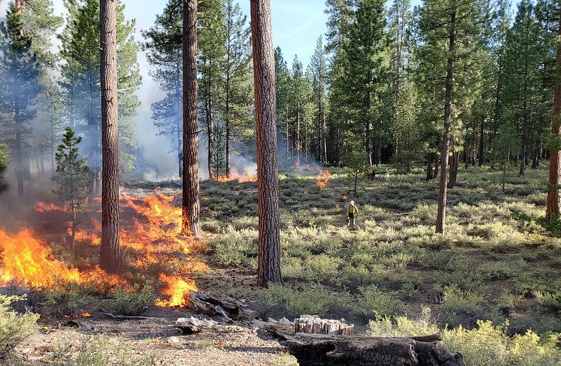
SISTERS, Ore. (KTVZ) -- On Tuesday, fuels specialists on the Sisters Ranger District plan to conduct a 120-acre prescribed burn in the Metolius Basin south of the Metolius Meadows community, if favorable conditions persist.
Ignitions are slated to begin mid-morning and continue throughout the day. Firefighters will mop up and patrol the prescribed burn area for several days.
No road closures are expected; however, drivers on Forest Service Roads 14 and 1419 may experience some smoke impacts. Fire managers will place signage where needed.
A portion of the burn borders a half-mile stretch of the Metolius-Windigo Trail. Trail users should anticipate a trail closure or reroute during ignitions on Tuesday. Smoke could impact the trail throughout the week.
The understory burn reintroduces fire into a fire-adapted ecosystem and serves as the final phase in restoration efforts that have included thinning and pile burning. This restoration effort improves forest health while reducing the risk of high-intensity wildfire in the Metolius Basin.
Sisters Ranger District fuels specialists plan to continue prescribed burning throughout October, targeting project areas in the Metolius Basin, Sisters Area Fuels Reduction area and adjacent to Highway 20. Prescribed burns will be scheduled to take advantage of fall weather and preferred fuels conditions.
Meanwhile, also on Tuesday, fuels specialists on the Crescent Ranger District plan to conduct a 31-acre prescribed burn located 3 1/2 miles southwest of Crescent Lake Junction, near the eastern portion of Crescent Lake. If favorable conditions exist and time allows, fuels specialists may conduct an additional 84-acre prescribed burn in the same area.
Fuels specialists are implementing the understory burn to reduce hazardous fuels accumulation decreasing the risk of high-intensity wildfire in the area by providing increased defensible space to protect the Crescent Lake community. Additionally, implementing prescribed fire restores the health of the fire-adapted ecosystem while helping to improve late-successional forest conditions.
Smoke may be visible from Highway 58 and Crescent Lake Junction following ignitions. Fuels specialists will monitor smoke impacts to Highway 58 and place warning signs where needed. Firefighters patrol the burn for several days following ignitions until it is declared out.
Fire management officials work with Oregon Department of Forestry smoke specialists to analyze weather conditions and anticipated smoke dispersion to determine burn dates.
When smoke is present, motorists should reduce speed and turn on headlights. All efforts will be made to limit smoke impacts to area neighborhoods and communities. The possibility exists for smoke to settle in low-lying areas due to cool nighttime temperatures. Residents in areas near burn operations are encouraged to close windows at night to avoid possible smoke impacts.
For more information on hazardous fuels reduction projects in Central Oregon, visit the interactive website at http://www.centraloregonfire.org/ or visit www.fs.usda.gov/deschutes and follow on Twitter @CentralORFire. For further questions, contact the Bend-Fort Rock Ranger District at (541) 549-7700.
