Wildfires update: Cedar Creek Fire reaches 1,200 acres; Fly Creek Fire evacuation levels lifted
(Update: Jefferson County Sheriff's Office lifts evacuation levels)
BEND, Ore. (KTVZ) -- The Cedar Creek Fire near Waldo Lake that sent smoke streaming into Central Oregon on Wednesday has more than doubled in size, to about 1,200 acres, officials said Thursday, while progress on the Fly Creek Fire allowed officials to lift evacuation levels for Three Rivers, Montgomery Shores and two campgrounds.
Here's the Willamette National Forest's Thursday morning update posted to Facebook, along with updates on other fires around the region:
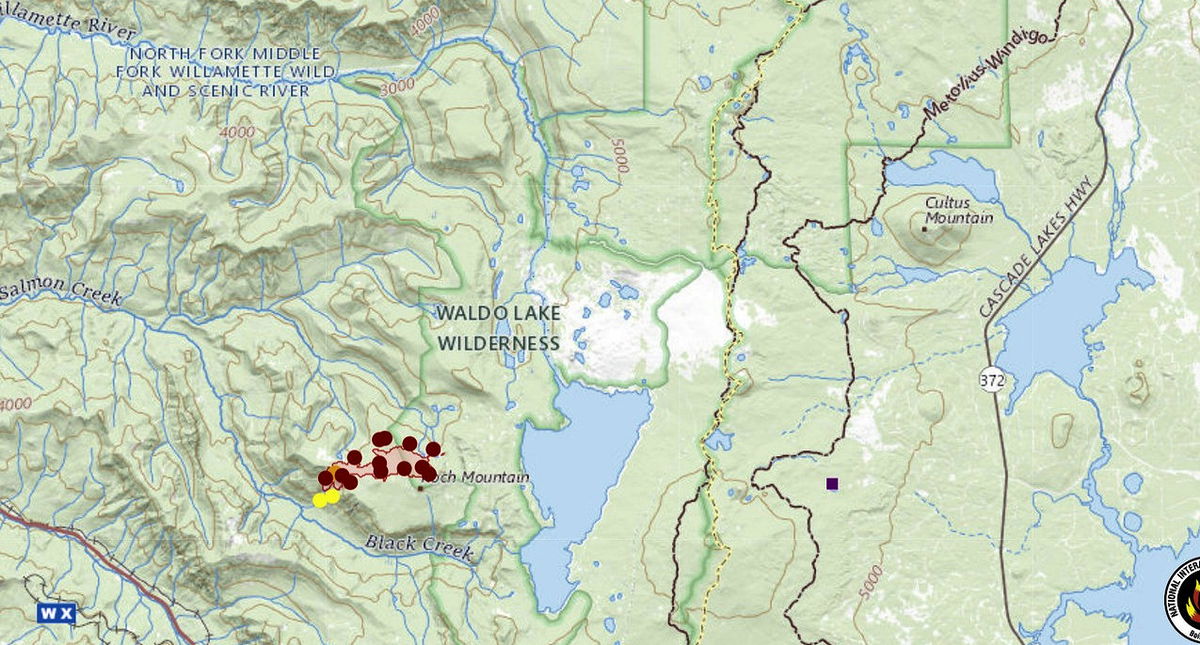
The Cedar Creek Fire, which was detected Monday about 3.5 miles west of Waldo Lake on the Willamette National Forest after a lightning storm, made a significant move north and east last night. The fire is now around 1,200 acres, burning in heavy timber. The forest is closing the entire Waldo Lake Wilderness Area as a precaution, as the fire is headed in that direction, away from the community of Oakridge.
While there is no need to panic, local engines patrolled the area last night to get campers and other recreationists out of the area and are continuing that effort this morning. In addition, the public can expect a reverse 911 call at some point.
Anyone with friends or family recreating in that area or headed that way are asked to try to contact them, and inform them of the closure and the need to leave the area. If family or friends are known to be in that area but cannot be reached, please call the Lane County Non-Emergency line at 541-682-4150 and the message will be relayed to those on patrol.
The two fires in the Three Sister Wilderness area reported last night are being staffed this morning by smokejumpers. One is 5 acres and one is 1/10th of an acre.
As long as the fire continues its move north and east, smoke will be an issue in communities to the north and east like Bend and Sisters and may make recreating unpleasant. Smoke often settles into low-lying areas and river corridors overnight. The public is advised to ensure all windows and doors are securely closed in the evening and early morning hours to limit smoke exposure. For more information and tips on keeping your family safe this summer, visit the smoke information blogs for Oregon or Washington at http://oregonsmoke.blogspot.com/ and http://wasmoke.blogspot.com/. Also check out the Smoke-Ready Toolbox for Wildfires | US EPA webpage and https://fire.airnow.gov/ for additional resources and current air quality readings in your area.
Green Butte Fire Update – August 4, 2022, 9 a.m.
Central Oregon— Firefighters responded to Incident #537, the Green Butte Fire, on the evening of Tuesday, August 2. The fire is located on the Bend-Fort Rock Ranger District on the Deschutes National Forest approximately 13 miles southeast of La Pine and approximately two miles northeast of Spring Butte. The fire is currently mapped at 22.9 acres and 0% contained.
Yesterday, firefighters stopped forward progress and completed the installation of a hose line around the fire. Due to increased complexity, a local Type 3 Incident Management Team led by Incident Commander Andrew Myhra will take command of the fire today. The incoming incident management team will in-brief at 10:30 a.m.
Resources assigned to the Green Butte Fire include the Prineville Hotshots, two hand crews, four engines, three water tenders, and one dozer. Air resources are available if needed.
For current wildland fire information, the public can visit centraloregonfire.org or follow fire information on Twitter @CentralORFire.
Central Oregon Interagency Dispatch Update – August 4, 9 AM
Central Oregon – No new fires were reported last night. Fire activity was minimal overnight on existing fires and there were no significant changes.
There were no changes on the 274-acre Fly Creek Fire overnight, it remains 80% contained. This fire is located near Balancing Rock along the Metolius arm of Lake Billy Chinook on the Deschutes National Forest. Resources will be on scene again today mopping up and working to increase containment. Air support will be available if needed. Portions of Lake Billy Chinook may be closed for public safety if air resources need to dip out of the lake.
The Level 1 evacuation notice for the Three Rivers area and the Level 3 evacuation notice for the Perry South and Monty Campgrounds were lifted Thursday afternoon, although officials said firefighters will be using the Perry South location until Friday morning and asked people to "please avoid Perry South untul then." For information on evacuations, please visit: https://www.facebook.com/JeffersonCountyORSheriff.
The firefighters have maintained 50% containment on the 1.6-acre Juniper Creek Fire. This fire is located roughly 10 air-miles south of the Fly Creek Fire and resources will be on scene again today extinguishing hot spots and strengthening control lines. Incident 535 which is located roughly 20 miles southeast of Bend and north of Hwy 20 was contained yesterday at 0.5 acres.
Weather conditions are expected to be slightly cooler today with no lightning in the forecast. Despite the slightly cooler temperatures, conditions will generally be warm and dry with low relative humidity across the area. Strong winds are predicted in some areas. Fire officials anticipate that more hold-over fires may be discovered and are prepared to respond.
As we move into the weekend, fire officials would like to remind the public to exercise caution, as the potential for fire growth remains high. Check for fire restrictions before making plans to have a campfire. For restrictions information, visit: https://www.centraloregonfire.org/. If you do decide to enjoy a campfire in an approved fire ring at a designated campground, remember to drown, stir and feel before walking away. It should be cool enough to touch with your hand. Check your trailer chains to ensure they aren’t dragging; this can cause sparks. Avoid driving over or parking on dry vegetation. Fewer human-caused wildfires means that firefighters can focus on the natural-caused wildfires that we can’t prevent.
Central Oregon may experience smoke impacts again today from a few different active fires on neighboring forests and further south in California. Smoke often settles into low-lying areas and river corridors overnight. The public is advised to ensure all windows and doors are securely closed in the evening and early morning hours to limit smoke exposure. For air quality information, visit: https://fire.airnow.gov/ or https://www.airnow.gov/. For more information on how to limit your smoke exposure, visit: https://www.centraloregonfire.org/wildfire-smoke-your-health/.
For current wildland fire information, the public can visit centraloregonfire.org or follow fire information on Twitter @CentralORfire.
Miller Road Fire Update
Thursday, August 4, 2022 9:00 a.m.
OSFM Blue Team Scott Magers, IC
Miller Road Fire Information: (503) 383-9278 (8am - 6pm)
Email: osfm.fireinformation@gmail.com
Facebook: https://www.facebook.com/OfficialMillerRoadFire
Estimated size: 10,500 acres
Containment: 0%
Start Date/Time: 8/2/22
Location: Juniper Flat, Wasco County
Casue: Under investigation
Resources: 315
Engines: 36
Dozers: 8
Water Tenders: 12
Air Assets: As Neded
9 STructure TAsk Forces
Structures threatened: 881
Structures Damaged: Under Assessment
Structures Destroyed: 1
Wasco County, OR – OSFM Task Forces and ODF crews completed their
first 24-hour work cycle. Crews worked to create fire containment lines
and were supported by air operations. Dozer lines and hand lines were
established in the southeast corner of the fire near Ditch Road and Natural
Pasture Road. Additional lines were also completed to the north near Old
Wapinitia Road.
Firefighters called in aircraft for retardant and water drops to assist with
fire suppression and containment.
Late into the afternoon, the fire spotted over the line east of Batty Road
and west of Old Wapinitia Road in a field of wheat. Crews and landowners were able to extinguish it and back burn to create some black.
With great sadness, we are reporting one primary residence was lost to
the fire. Fire crews were working to protect the structure at the time.
High winds and ember showers were present.
Four Task Forces and one dozer were assigned evening shift. There were
no new starts, and the fire did lay down. Today, firefighters will begin the
mop-up process on the heel of the fire, along west Miller Road. They will
be checking for hot spots and increasing the control line.
Cooler conditions are expected today with temperatures reaching 82-85
degrees. Westerly winds are predicted to be 5-10 mph. Minimal relative
humidity recovery overnight. The weekend forecast predicts
temperatures increasing to 100 degrees.
A media line tour is scheduled for 1 p.m. Journalists must bring all line
safety personal protective gear. The fire is not able to provide any PPE.
Please call to confirm attendance: 541-979-4096.
We are grateful for the cooperation and support of the Wasco County
community, ODF partners, BLM cooperators and the firefighters dedicated
to this incident.
An evacuation shelter has been established at the Dufur High School, 802
NE 5th Street.
Wasco County Sheriff’s Office evacuation details can be found by visiting
https://www.facebook.com/WascoCountySheriff.
